Property Record
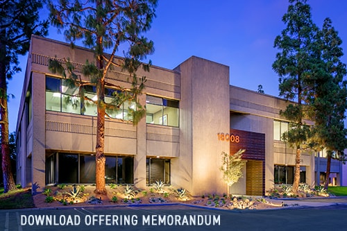
18008 Sky Park Cir, Irvine, CA 92614


Current Lease Availabilities
NEARBY LISTINGS FOR SALE OR LEASE
Property Detail
18008 Sky Park Cir
Anaheim-Santa Ana-Irvine, CA
City/Irvine
427-206-03
P BK 142 PG 29 PAR 3
Commercialnec
Orange
X
California
06059C0278J
3
2024
1.26 AC
2025
Irvine/Tustin Legacy
075516
Orange County (California)
DEMOGRAPHICS near 18008 Sky Park Cir
1 Mile
3 Mile
5 Mile
2024 Total Population
5,291
164,681
578,725
2029 Population
5,422
162,921
571,729
Pop Growth 2024-2029
+ 2.48%
(1.07%)
(1.21%)
Average Age
36
37
37
2024 Total Households
2,513
58,300
183,863
HH Growth 2024-2029
+ 2.59%
(0.95%)
(1.20%)
Median Household Inc
$110,263
$99,035
$94,571
Avg Household Size
2.00
2.70
2.90
2024 Avg HH Vehicles
2.00
2.00
2.00
Median Home Value
$827,712
$781,150
$813,456
Median Year Built
2009
1983
1976
Nearby Places
Map Layers
Map Styles
 Street
 Aerial
- Restaurants
- Banks
- Shops
- Fitness
- Groceries
PUBLIC TRANSPORTATION
COMMUTER RAIL
Tustin (Inland Empire-Orange County Line - Southern California Regional Rail Authority (Metrolink), Orange County Line - Southern California Regional Rail Authority (Metrolink))
DRIVE
WALK
Distance
Tustin (Inland Empire-Orange County Line - Southern California Regional Rail Authority (Metrolink), Orange County Line - Southern California Regional Rail Authority (Metrolink))
9 min
4.5 mi
Santa Ana (Inland Empire-Orange County Line - Southern California Regional Rail Authority (Metrolink), Orange County Line - Southern California Regional Rail Authority (Metrolink))
DRIVE
WALK
Distance
Santa Ana (Inland Empire-Orange County Line - Southern California Regional Rail Authority (Metrolink), Orange County Line - Southern California Regional Rail Authority (Metrolink))
11 min
6.7 mi
AIRPORT
John Wayne/Orange County
DRIVE
WALK
Distance
John Wayne/Orange County
4 min
1.7 mi
Long Beach (Daugherty Field)
DRIVE
WALK
Distance
Long Beach (Daugherty Field)
29 min
23.1 mi
Ontario International
DRIVE
WALK
Distance
Ontario International
53 min
41.5 mi
Freight Ports
Port of Long Beach
DRIVE
WALK
Distance
Port of Long Beach
34 min
22.6 mi
Nearby Properties
Address
Land Use
TOTAL SIZE
Lot Size
Zoning
Address
Land Use
TOTAL SIZE
Lot Size
Zoning
28.01 AC
Address
Land Use
TOTAL SIZE
Lot Size
Zoning
11.29 AC
Address
Land Use
TOTAL SIZE
Lot Size
Zoning
Address
Land Use
TOTAL SIZE
Lot Size
Zoning
15.99 AC
Address
Land Use
TOTAL SIZE
Lot Size
Zoning
12.03 AC
Address
Land Use
TOTAL SIZE
Lot Size
Zoning
5.11 AC
Address
Land Use
TOTAL SIZE
Lot Size
Zoning
21.56 AC
Address
Land Use
TOTAL SIZE
Lot Size
Zoning
63.17 AC
Address
Land Use
TOTAL SIZE
Lot Size
Zoning
40.31 AC
Address
Land Use
TOTAL SIZE
Lot Size
Zoning
21,500 SF
2 AC
CO
Address
Land Use
TOTAL SIZE
Lot Size
Zoning
102,528 SF
7.50 AC
Address
Land Use
TOTAL SIZE
Lot Size
Zoning
9.44 AC
Address
Land Use
TOTAL SIZE
Lot Size
Zoning
4.89 AC
Address
Land Use
TOTAL SIZE
Lot Size
Zoning
5.16 AC
Address
Land Use
TOTAL SIZE
Lot Size
Zoning
24,680 SF
3.63 AC
Address
Land Use
TOTAL SIZE
Lot Size
Zoning
3.06 AC
Address
Land Use
TOTAL SIZE
Lot Size
Zoning
5.29 AC
Address
Land Use
TOTAL SIZE
Lot Size
Zoning
Address
Land Use
TOTAL SIZE
Lot Size
Zoning
1.52 AC
Address
Land Use
TOTAL SIZE
Lot Size
Zoning
Address
Land Use
TOTAL SIZE
Lot Size
Zoning
9.27 AC
Address
Land Use
TOTAL SIZE
Lot Size
Zoning
9.60 AC
Address
Land Use
TOTAL SIZE
Lot Size
Zoning
4.29 AC
Address
Land Use
TOTAL SIZE
Lot Size
Zoning
Address
Land Use
TOTAL SIZE
Lot Size
Zoning
24.73 AC
Address
Land Use
TOTAL SIZE
Lot Size
Zoning
7.42 AC
Address
Land Use
TOTAL SIZE
Lot Size
Zoning
8.95 AC
Address
Land Use
TOTAL SIZE
Lot Size
Zoning
20.80 AC
Address
Land Use
TOTAL SIZE
Lot Size
Zoning
4.50 AC
Address
Land Use
TOTAL SIZE
Lot Size
Zoning
10.68 AC
The World's #1 Commercial Real Estate Marketplace
Connect with us
© 2025 CoStar Group
The information above has been obtained from sources believed reliable. While we do not doubt its accuracy we have not verified it and make no guarantee, warranty or representation about it. It is your responsibility to independently confirm its accuracy and completeness. Any projections, opinions, assumptions, or estimates used are for example only and do not represent the current or future performance of the property. The value of this transaction to you depends on tax and other factors which should be evaluated by your tax, financial, and legal advisors. You and your advisors should conduct a careful, independent investigation of the property to determine to your satisfaction the suitability of the property for your needs.