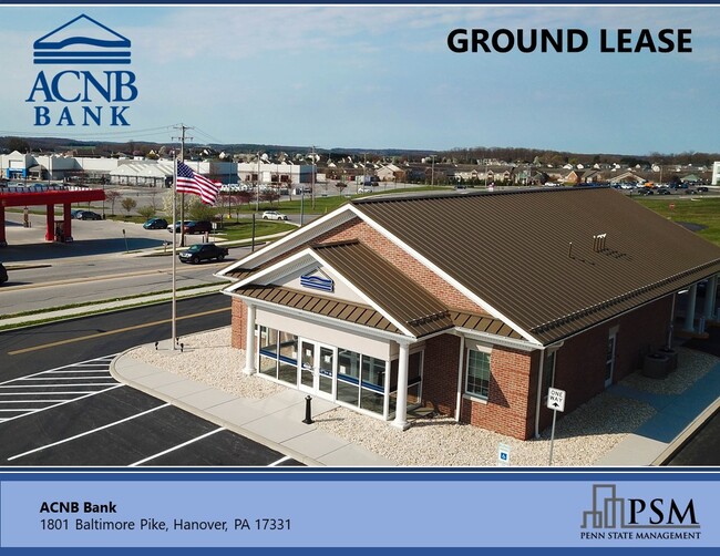
Property Record
1801 Baltimore Pike, Hanover, PA 17331


Save to a Folder
{{folder.Name}}
{{folder.ListingIds.length}} Properties
{{folder.ListingIds.length}} Property
Create a New Folder
Property Detail
1801 Baltimore Pike
52-000-BD-0044.X0-00000
York
Financialbuilding
Pennsylvania
B and X Area of moderate flood hazard, usually the area between the limits of the 100-year and 500-year floods.
1.16 AC
2026
York County
2026
Philadelphia
022403
York-Hanover, PA
2,491 SF
NEARBY LISTINGS FOR SALE OR LEASE
DEMOGRAPHICS near 1801 Baltimore Pike
1 mile
3 mile
5 mile
2025 Total Population
7,139
34,271
60,096
2030 Population
7,509
35,670
62,125
Pop Growth 2025-2030
+ 5.18%
+ 4.08%
+ 3.38%
Average Age
41
42
42
2025 Total Households
2,635
13,180
23,945
HH Growth 2025-2030
+ 5.35%
+ 4.19%
+ 3.48%
Median Household Inc
$93,073
$77,068
$76,171
Avg Household Size
2.70
2.50
2.40
2025 Avg HH Vehicles
2.00
2.00
2.00
Median Home Value
$267,496
$249,722
$253,740
Median Year Built
2000
1982
1977
Nearby Places
Map Layers
Map Styles
 Street
 Aerial
Layers
 Traffic
 Biking
Places
Listings with unknown addresses are not visible on the map
- Restaurants
- Banks
- Shops
- Fitness
- Groceries
SALE & LEASE HISTORY
LISTING DATE
SALE/LEASE

Apr 23, 2021
For Sale
Nearby Properties
Address
Land Use
TOTAL SIZE
Lot Size
Zoning
Address
Land Use
TOTAL SIZE
Lot Size
Zoning
65,738 SF
89.96 AC
RS
Address
Land Use
TOTAL SIZE
Lot Size
Zoning
19.01 AC
Address
Land Use
TOTAL SIZE
Lot Size
Zoning
59,212 SF
38.80 AC
RS
Address
Land Use
TOTAL SIZE
Lot Size
Zoning
15.58 AC
SC
Address
Land Use
TOTAL SIZE
Lot Size
Zoning
307,500 SF
23.24 AC
ID
Address
Land Use
TOTAL SIZE
Lot Size
Zoning
49,736 SF
20.73 AC
CM
Address
Land Use
TOTAL SIZE
Lot Size
Zoning
6.16 AC
CI
Address
Land Use
TOTAL SIZE
Lot Size
Zoning
Address
Land Use
TOTAL SIZE
Lot Size
Zoning
183,195 SF
22.71 AC
CI
Address
Land Use
TOTAL SIZE
Lot Size
Zoning
Address
Land Use
TOTAL SIZE
Lot Size
Zoning
369,686 SF
13.75 AC
ID
Address
Land Use
TOTAL SIZE
Lot Size
Zoning
1,704 SF
7.93 AC
SR
Address
Land Use
TOTAL SIZE
Lot Size
Zoning
9.68 AC
ID
Address
Land Use
TOTAL SIZE
Lot Size
Zoning
46,696 SF
5.79 AC
CM
Address
Land Use
TOTAL SIZE
Lot Size
Zoning
1,560 SF
255.36 AC
RS
Address
Land Use
TOTAL SIZE
Lot Size
Zoning
33,120 SF
6.95 AC
RS
Address
Land Use
TOTAL SIZE
Lot Size
Zoning
51,520 SF
4.31 AC
RS
Address
Land Use
TOTAL SIZE
Lot Size
Zoning
29,992 SF
1.86 AC
CM
Address
Land Use
TOTAL SIZE
Lot Size
Zoning
7,100 SF
3.68 AC
R8
Address
Land Use
TOTAL SIZE
Lot Size
Zoning
56,044 SF
1.29 AC
Address
Land Use
TOTAL SIZE
Lot Size
Zoning
37,454 SF
6.12 AC
RS
Address
Land Use
TOTAL SIZE
Lot Size
Zoning
120,645 SF
10.22 AC
ID
Address
Land Use
TOTAL SIZE
Lot Size
Zoning
33,786 SF
0.42 AC
RS
Address
Land Use
TOTAL SIZE
Lot Size
Zoning
3.23 AC
RS
Address
Land Use
TOTAL SIZE
Lot Size
Zoning
3.54 AC
Address
Land Use
TOTAL SIZE
Lot Size
Zoning
79,660 SF
9.45 AC
CM
Address
Land Use
TOTAL SIZE
Lot Size
Zoning
54,186 SF
2.07 AC
RS
Address
Land Use
TOTAL SIZE
Lot Size
Zoning
11,000 SF
3 AC
RS
Address
Land Use
TOTAL SIZE
Lot Size
Zoning
2.44 AC
RS
Address
Land Use
TOTAL SIZE
Lot Size
Zoning
5.22 AC
CI
The World's #1 Commercial Real Estate Marketplace
Connect with us
© 2026 CoStar Group
The information above has been obtained from sources believed reliable. While we do not doubt its accuracy we have not verified it and make no guarantee, warranty or representation about it. It is your responsibility to independently confirm its accuracy and completeness. Any projections, opinions, assumptions, or estimates used are for example only and do not represent the current or future performance of the property. The value of this transaction to you depends on tax and other factors which should be evaluated by your tax, financial, and legal advisors. You and your advisors should conduct a careful, independent investigation of the property to determine to your satisfaction the suitability of the property for your needs.