Property Record
1801 County Road 332, Jarrell, TX 76537
Save to a Folder
{{folder.Name}}
{{folder.ListingIds.length}} Properties
{{folder.ListingIds.length}} Property
Create a New Folder
Property Detail
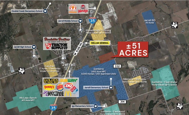
1801 County Road 332
Austin-Round Rock-San Marcos, TX
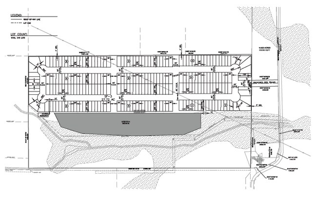
AW0054 BUNKER, I. SUR., ACRES 17.200
R011620
WILLIAMSON
Farms
Texas
A Areas with a 1% annual chance of flooding and a 26% chance of flooding over the life of a 30-year mortgage.
17.20 AC
2024
Georgetown
2025
Austin
021601
NEARBY LISTINGS FOR SALE OR LEASE
DEMOGRAPHICS near 1801 County Road 332
1 mile
3 mile
5 mile
2025 Total Population
7,593
19,543
21,170
2030 Population
8,986
23,375
25,299
Pop Growth 2025-2030
+ 18.35%
+ 19.61%
+ 19.50%
Average Age
34
36
36
2025 Total Households
2,675
6,726
7,297
HH Growth 2025-2030
+ 18.80%
+ 20.13%
+ 20.01%
Median Household Inc
$91,572
$89,691
$90,938
Avg Household Size
2.80
2.90
2.90
2025 Avg HH Vehicles
2.00
2.00
2.00
Median Home Value
$282,576
$324,794
$330,662
Median Year Built
2011
2011
2011
Nearby Places
Map Layers
Map Styles
 Street
 Aerial
Layers
 Traffic
 Biking
Places
Listings with unknown addresses are not visible on the map
- Restaurants
- Banks
- Shops
- Fitness
- Groceries
PUBLIC TRANSPORTATION
AIRPORT
Killeen Municipal
Drive
Walk
Distance
Killeen Municipal
40 min
27.6 mi
Robert Gray AAF
Drive
Walk
Distance
Robert Gray AAF
54 min
38.2 mi
Freight Ports
Port of Houston
Drive
Walk
Distance
Port of Houston
229 min
195.7 mi
SALE & LEASE HISTORY
LISTING DATE
SALE/LEASE

Oct 30, 2023
For Sale
Dec 04, 2023
For Sale
Nearby Properties
Address
Land Use
TOTAL SIZE
Lot Size
Zoning
Address
Land Use
TOTAL SIZE
Lot Size
Zoning
19.23 AC
Address
Land Use
TOTAL SIZE
Lot Size
Zoning
253,037 SF
16.36 AC
Address
Land Use
TOTAL SIZE
Lot Size
Zoning
110,565 SF
14.29 AC
Address
Land Use
TOTAL SIZE
Lot Size
Zoning
300,531 SF
15.03 AC
Address
Land Use
TOTAL SIZE
Lot Size
Zoning
57.95 AC
Address
Land Use
TOTAL SIZE
Lot Size
Zoning
1,216 SF
55.78 AC
Address
Land Use
TOTAL SIZE
Lot Size
Zoning
132,200 SF
7.92 AC
Address
Land Use
TOTAL SIZE
Lot Size
Zoning
120,837 SF
8.44 AC
Address
Land Use
TOTAL SIZE
Lot Size
Zoning
98,000 SF
74.75 AC
Address
Land Use
TOTAL SIZE
Lot Size
Zoning
29,000 SF
25 AC
Address
Land Use
TOTAL SIZE
Lot Size
Zoning
15.03 AC
Address
Land Use
TOTAL SIZE
Lot Size
Zoning
1,942 SF
17.40 AC
Address
Land Use
TOTAL SIZE
Lot Size
Zoning
20,414 SF
8.27 AC
Address
Land Use
TOTAL SIZE
Lot Size
Zoning
58,543 SF
6.74 AC
Address
Land Use
TOTAL SIZE
Lot Size
Zoning
33.99 AC
Address
Land Use
TOTAL SIZE
Lot Size
Zoning
14,297 SF
6.71 AC
Address
Land Use
TOTAL SIZE
Lot Size
Zoning
15,615 SF
2.39 AC
Address
Land Use
TOTAL SIZE
Lot Size
Zoning
68,261 SF
4.12 AC
Address
Land Use
TOTAL SIZE
Lot Size
Zoning
24.75 AC
Address
Land Use
TOTAL SIZE
Lot Size
Zoning
83,362 SF
10 AC
Address
Land Use
TOTAL SIZE
Lot Size
Zoning
43,852 SF
3 AC
Address
Land Use
TOTAL SIZE
Lot Size
Zoning
21,844 SF
3.25 AC
Address
Land Use
TOTAL SIZE
Lot Size
Zoning
30,996 SF
12.02 AC
Address
Land Use
TOTAL SIZE
Lot Size
Zoning
17.89 AC
Address
Land Use
TOTAL SIZE
Lot Size
Zoning
20,000 SF
7.90 AC
Address
Land Use
TOTAL SIZE
Lot Size
Zoning
32,220 SF
4 AC
Address
Land Use
TOTAL SIZE
Lot Size
Zoning
16.79 AC
Address
Land Use
TOTAL SIZE
Lot Size
Zoning
25,000 SF
2.99 AC
Address
Land Use
TOTAL SIZE
Lot Size
Zoning
24,668 SF
3.41 AC
Address
Land Use
TOTAL SIZE
Lot Size
Zoning
201.67 AC
The World's #1 Commercial Real Estate Marketplace
Connect with us
© 2026 CoStar Group
The information above has been obtained from sources believed reliable. While we do not doubt its accuracy we have not verified it and make no guarantee, warranty or representation about it. It is your responsibility to independently confirm its accuracy and completeness. Any projections, opinions, assumptions, or estimates used are for example only and do not represent the current or future performance of the property. The value of this transaction to you depends on tax and other factors which should be evaluated by your tax, financial, and legal advisors. You and your advisors should conduct a careful, independent investigation of the property to determine to your satisfaction the suitability of the property for your needs.