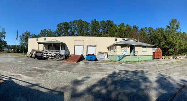
Property Record
1801 Harrietts Bluff Rd, Woodbine, GA 31569


NEARBY LISTINGS FOR SALE OR LEASE
Property Detail
1801 Harrietts Bluff Rd
093-017A
Harrietts Bluff Exit Sm Ac Com
Commercialnec
COMM (RECYCLE)/L PARCEL D I-95
X
Camden
13039C0385G
Georgia
2025
3.19 AC
2025
Brunswick/Kingsland
010202
Other Market Areas
7,360 SF
Kingsland, GA
DEMOGRAPHICS near 1801 Harrietts Bluff Rd
1 Mile
3 Mile
5 Mile
2024 Total Population
69
3,379
22,323
2029 Population
75
3,746
24,544
Pop Growth 2024-2029
+ 8.70%
+ 10.86%
+ 9.95%
Average Age
39
38
37
2024 Total Households
26
1,268
8,341
HH Growth 2024-2029
+ 7.69%
+ 11.12%
+ 10.03%
Median Household Inc
$81,250
$60,971
$61,587
Avg Household Size
2.70
2.60
2.60
2024 Avg HH Vehicles
2.00
2.00
2.00
Median Home Value
$225,000
$232,741
$196,038
Median Year Built
1993
1997
1998
Nearby Places
Map Layers
Map Styles
 Street
 Aerial
- Restaurants
- Banks
- Shops
- Fitness
- Groceries
PUBLIC TRANSPORTATION
AIRPORT
Jacksonville International
DRIVE
WALK
Distance
Jacksonville International
38 min
29.4 mi
Brunswick Golden Isles
DRIVE
WALK
Distance
Brunswick Golden Isles
43 min
34.1 mi
SALE & LEASE HISTORY
LISTING DATE
SALE/LEASE

Oct 18, 2024
For Sale
Nearby Properties
Address
Land Use
TOTAL SIZE
Lot Size
Zoning
Address
Land Use
TOTAL SIZE
Lot Size
Zoning
256,459 SF
38.54 AC
R-1
Address
Land Use
TOTAL SIZE
Lot Size
Zoning
184,547 SF
34.90 AC
R-1
Address
Land Use
TOTAL SIZE
Lot Size
Zoning
74,567 SF
49 AC
R-1
Address
Land Use
TOTAL SIZE
Lot Size
Zoning
2,833 SF
22.34 AC
PD/C2
Address
Land Use
TOTAL SIZE
Lot Size
Zoning
9,530 SF
10.71 AC
PD/R-3
Address
Land Use
TOTAL SIZE
Lot Size
Zoning
87,500 SF
8.35 AC
I-L
Address
Land Use
TOTAL SIZE
Lot Size
Zoning
25 AC
R-1
Address
Land Use
TOTAL SIZE
Lot Size
Zoning
31,491 SF
3.42 AC
R-1
Address
Land Use
TOTAL SIZE
Lot Size
Zoning
18,000 SF
3.51 AC
R-1
Address
Land Use
TOTAL SIZE
Lot Size
Zoning
18,000 SF
23.91 AC
R-1
Address
Land Use
TOTAL SIZE
Lot Size
Zoning
18,352 SF
5 AC
C-2
Address
Land Use
TOTAL SIZE
Lot Size
Zoning
52,775 SF
11.20 AC
I-G
Address
Land Use
TOTAL SIZE
Lot Size
Zoning
15,102 SF
5 AC
R-1
Address
Land Use
TOTAL SIZE
Lot Size
Zoning
8,840 SF
4.86 AC
C4
Address
Land Use
TOTAL SIZE
Lot Size
Zoning
1,044.50 AC
I-G
Address
Land Use
TOTAL SIZE
Lot Size
Zoning
27,500 SF
5.84 AC
IL
Address
Land Use
TOTAL SIZE
Lot Size
Zoning
9,715 SF
6.96 AC
C-2
Address
Land Use
TOTAL SIZE
Lot Size
Zoning
3,648 SF
19.31 AC
C4
Address
Land Use
TOTAL SIZE
Lot Size
Zoning
5,307 SF
6.90 AC
C-4
Address
Land Use
TOTAL SIZE
Lot Size
Zoning
1,943 SF
7 AC
R-3
Address
Land Use
TOTAL SIZE
Lot Size
Zoning
9,100 SF
1.31 AC
C-2
Address
Land Use
TOTAL SIZE
Lot Size
Zoning
8,988 SF
2.23 AC
C-2
Address
Land Use
TOTAL SIZE
Lot Size
Zoning
6,032 SF
9.43 AC
R-3
Address
Land Use
TOTAL SIZE
Lot Size
Zoning
2,400 SF
2.40 AC
C-G
Address
Land Use
TOTAL SIZE
Lot Size
Zoning
22,388 SF
2 AC
I-G
Address
Land Use
TOTAL SIZE
Lot Size
Zoning
4,500 SF
129.64 AC
A-F
Address
Land Use
TOTAL SIZE
Lot Size
Zoning
625 SF
5.71 AC
C-I
Address
Land Use
TOTAL SIZE
Lot Size
Zoning
2,400 SF
20.26 AC
I-G
Address
Land Use
TOTAL SIZE
Lot Size
Zoning
6,805 SF
1.03 AC
R-1
The World's #1 Commercial Real Estate Marketplace
Connect with us
© 2026 CoStar Group
The information above has been obtained from sources believed reliable. While we do not doubt its accuracy we have not verified it and make no guarantee, warranty or representation about it. It is your responsibility to independently confirm its accuracy and completeness. Any projections, opinions, assumptions, or estimates used are for example only and do not represent the current or future performance of the property. The value of this transaction to you depends on tax and other factors which should be evaluated by your tax, financial, and legal advisors. You and your advisors should conduct a careful, independent investigation of the property to determine to your satisfaction the suitability of the property for your needs.