Property Record
1801 Harwood Rd, Arlington, TX 76021


Save to a Folder
{{folder.Name}}
{{folder.ListingIds.length}} Properties
{{folder.ListingIds.length}} Property
Create a New Folder
Property Detail
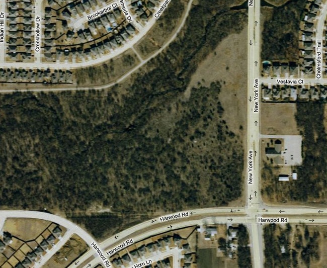
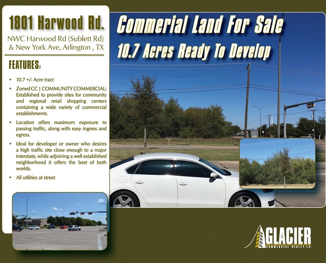
1801 Harwood Rd
Dallas-Fort Worth-Arlington, TX
BALCH, JOHN SURVEY ABSTRACT 83 TRACT 6D
05942799
TARRANT
Residentialacreage
Texas
AE The base floodplain where base flood elevations are provided. AE Zones are now used on new format FIRMs instead of A1-A30 Zones.
10.46 AC
2025
Arlington/Mansfield
2025
Dallas/Ft Worth
113630
NEARBY LISTINGS FOR SALE OR LEASE
DEMOGRAPHICS near 1801 Harwood Rd
1 mile
3 mile
5 mile
2025 Total Population
12,696
119,481
312,201
2030 Population
13,150
124,963
326,875
Pop Growth 2025-2030
+ 3.58%
+ 4.59%
+ 4.70%
Average Age
37
36
37
2025 Total Households
3,781
37,925
102,066
HH Growth 2025-2030
+ 3.76%
+ 4.78%
+ 4.81%
Median Household Inc
$95,546
$89,902
$87,783
Avg Household Size
3.20
3.10
3.00
2025 Avg HH Vehicles
2.00
2.00
2.00
Median Home Value
$283,544
$306,298
$328,651
Median Year Built
1990
1996
1994
Nearby Places
Map Layers
Map Styles
 Street
 Aerial
Layers
 Traffic
 Biking
Places
Listings with unknown addresses are not visible on the map
- Restaurants
- Banks
- Shops
- Fitness
- Groceries
PUBLIC TRANSPORTATION
AIRPORT
Dallas-Fort Worth International
Drive
Walk
Distance
Dallas-Fort Worth International
29 min
20.2 mi
Dallas Love Field
Drive
Walk
Distance
Dallas Love Field
39 min
28.8 mi
Freight Ports
Port of Shreveport
Drive
Walk
Distance
Port of Shreveport
231 min
214.5 mi
SALE & LEASE HISTORY
LISTING DATE
SALE/LEASE

Nov 06, 2017
For Sale
May 12, 2017
For Sale
Jan 23, 2017
For Sale
Nearby Properties
Address
Land Use
TOTAL SIZE
Lot Size
Zoning
Address
Land Use
TOTAL SIZE
Lot Size
Zoning
569,876 SF
47.80 AC
Address
Land Use
TOTAL SIZE
Lot Size
Zoning
399,570 SF
75.21 AC
Address
Land Use
TOTAL SIZE
Lot Size
Zoning
804,384 SF
48.38 AC
Address
Land Use
TOTAL SIZE
Lot Size
Zoning
529,992 SF
35.21 AC
Address
Land Use
TOTAL SIZE
Lot Size
Zoning
456,473 SF
32.79 AC
Address
Land Use
TOTAL SIZE
Lot Size
Zoning
1,114,563 SF
89.72 AC
Address
Land Use
TOTAL SIZE
Lot Size
Zoning
368,004 SF
13.89 AC
Address
Land Use
TOTAL SIZE
Lot Size
Zoning
453,257 SF
121.21 AC
Address
Land Use
TOTAL SIZE
Lot Size
Zoning
260,008 SF
139.37 AC
Address
Land Use
TOTAL SIZE
Lot Size
Zoning
419,875 SF
108.14 AC
Address
Land Use
TOTAL SIZE
Lot Size
Zoning
375,213 SF
17.77 AC
Address
Land Use
TOTAL SIZE
Lot Size
Zoning
298,234 SF
23.39 AC
Address
Land Use
TOTAL SIZE
Lot Size
Zoning
280,000 SF
10.85 AC
Address
Land Use
TOTAL SIZE
Lot Size
Zoning
270,214 SF
17.85 AC
Address
Land Use
TOTAL SIZE
Lot Size
Zoning
821,502 SF
45.37 AC
Address
Land Use
TOTAL SIZE
Lot Size
Zoning
352,999 SF
60.81 AC
Address
Land Use
TOTAL SIZE
Lot Size
Zoning
315,359 SF
15 AC
Address
Land Use
TOTAL SIZE
Lot Size
Zoning
229,000 SF
8.01 AC
Address
Land Use
TOTAL SIZE
Lot Size
Zoning
302,022 SF
15.37 AC
Address
Land Use
TOTAL SIZE
Lot Size
Zoning
193,680 SF
8.25 AC
Address
Land Use
TOTAL SIZE
Lot Size
Zoning
258,908 SF
22.41 AC
Address
Land Use
TOTAL SIZE
Lot Size
Zoning
252,416 SF
15.86 AC
Address
Land Use
TOTAL SIZE
Lot Size
Zoning
858,995 SF
41.93 AC
Address
Land Use
TOTAL SIZE
Lot Size
Zoning
772,625 SF
43.80 AC
Address
Land Use
TOTAL SIZE
Lot Size
Zoning
723,840 SF
39.78 AC
Address
Land Use
TOTAL SIZE
Lot Size
Zoning
264,503 SF
17.48 AC
Address
Land Use
TOTAL SIZE
Lot Size
Zoning
202,262 SF
12.59 AC
Address
Land Use
TOTAL SIZE
Lot Size
Zoning
260,816 SF
11.52 AC
Address
Land Use
TOTAL SIZE
Lot Size
Zoning
77,038 SF
11.46 AC
Address
Land Use
TOTAL SIZE
Lot Size
Zoning
557,478 SF
28.73 AC
The World's #1 Commercial Real Estate Marketplace
Connect with us
© 2026 CoStar Group
The information above has been obtained from sources believed reliable. While we do not doubt its accuracy we have not verified it and make no guarantee, warranty or representation about it. It is your responsibility to independently confirm its accuracy and completeness. Any projections, opinions, assumptions, or estimates used are for example only and do not represent the current or future performance of the property. The value of this transaction to you depends on tax and other factors which should be evaluated by your tax, financial, and legal advisors. You and your advisors should conduct a careful, independent investigation of the property to determine to your satisfaction the suitability of the property for your needs.