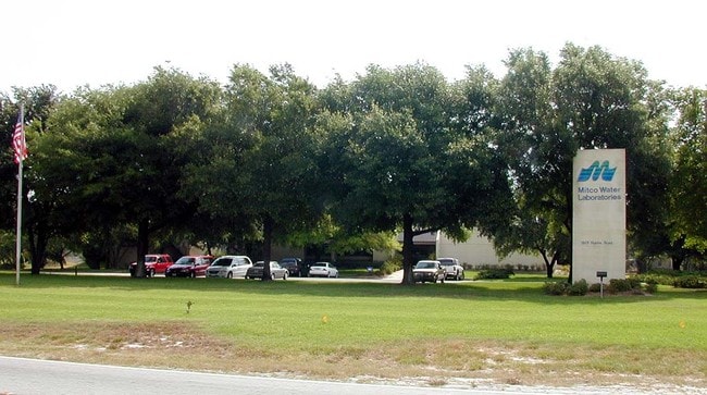
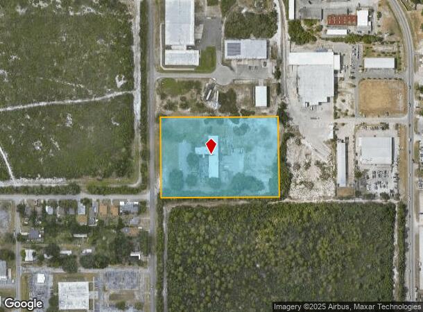
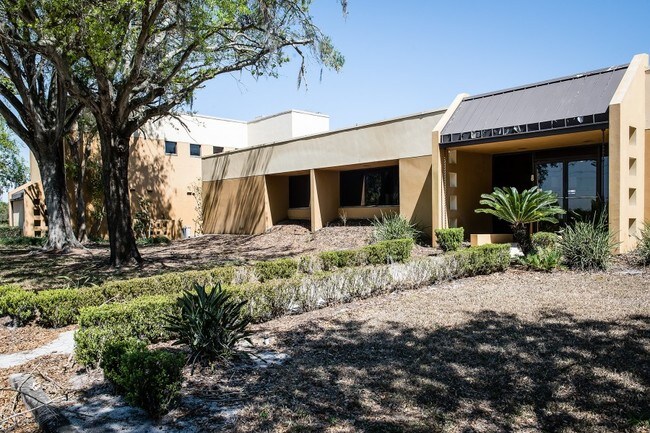
Property Record
1801 Hobbs Rd, Auburndale, FL 33823

NEARBY LISTINGS FOR SALE OR LEASE
Property Detail
1801 Hobbs Rd
25-28-14-000000-021060
Brierwood No 2
Lightindustrial
BEG NW COR NE1/4 OF SE1/4 RUN E 45 FT, S ALONG E R/W HOBBS RD 932.79 FT FOR POB CONT S 401.33 FT TO S LINE NE1/4 OF SE1/4 E 587.83 FT N 400.18 FT W 587.41 FT TO POB
X
Polk
12105C0345G
Florida
2024
5.38 AC
2025
Polk County
013300
Tampa/St Petersburg
19,875 SF
Lakeland-Winter Haven, FL
DEMOGRAPHICS near 1801 Hobbs Rd
1 Mile
3 Mile
5 Mile
2024 Total Population
4,543
45,552
105,132
2029 Population
5,451
54,788
126,654
Pop Growth 2024-2029
+ 19.99%
+ 20.28%
+ 20.47%
Average Age
39
40
40
2024 Total Households
1,699
17,540
40,542
HH Growth 2024-2029
+ 19.89%
+ 20.25%
+ 20.38%
Median Household Inc
$30,970
$50,069
$53,016
Avg Household Size
2.60
2.50
2.50
2024 Avg HH Vehicles
2.00
2.00
2.00
Median Home Value
$95,972
$176,691
$184,058
Median Year Built
1968
1978
1981
Nearby Places
Map Layers
Map Styles
 Street
 Aerial
- Restaurants
- Banks
- Shops
- Fitness
- Groceries
PUBLIC TRANSPORTATION
COMMUTER RAIL
DRIVE
WALK
Distance
12 min
5.2 mi
AIRPORT
Orlando International
DRIVE
WALK
Distance
Orlando International
67 min
47.7 mi
Freight Ports
Port of Tampa Bay
DRIVE
WALK
Distance
Port of Tampa Bay
68 min
46.2 mi
SALE & LEASE HISTORY
LISTING DATE
SALE/LEASE

Sep 23, 2016
For Sale
Mar 14, 2017
For Sale
Jun 28, 2018
For Sale
Dec 30, 2016
For Sale
Nearby Properties
Address
Land Use
TOTAL SIZE
Lot Size
Zoning
Address
Land Use
TOTAL SIZE
Lot Size
Zoning
942,646 SF
91.30 AC
R3
Address
Land Use
TOTAL SIZE
Lot Size
Zoning
250,170 SF
24.21 AC
Address
Land Use
TOTAL SIZE
Lot Size
Zoning
238,721 SF
11.66 AC
GI
Address
Land Use
TOTAL SIZE
Lot Size
Zoning
202,567 SF
189.02 AC
RE1
Address
Land Use
TOTAL SIZE
Lot Size
Zoning
215,942 SF
43.90 AC
Address
Land Use
TOTAL SIZE
Lot Size
Zoning
282,400 SF
19.59 AC
XX
Address
Land Use
TOTAL SIZE
Lot Size
Zoning
110,108 SF
10 AC
Address
Land Use
TOTAL SIZE
Lot Size
Zoning
136,724 SF
4.62 AC
GI
Address
Land Use
TOTAL SIZE
Lot Size
Zoning
200,200 SF
10.29 AC
Address
Land Use
TOTAL SIZE
Lot Size
Zoning
503,625 SF
20.61 AC
Address
Land Use
TOTAL SIZE
Lot Size
Zoning
108,360 SF
4.23 AC
GI
Address
Land Use
TOTAL SIZE
Lot Size
Zoning
148,390 SF
10.42 AC
R1
Address
Land Use
TOTAL SIZE
Lot Size
Zoning
188,553 SF
29.12 AC
Address
Land Use
TOTAL SIZE
Lot Size
Zoning
178,899 SF
10.09 AC
GI
Address
Land Use
TOTAL SIZE
Lot Size
Zoning
241,319 SF
5.67 AC
Address
Land Use
TOTAL SIZE
Lot Size
Zoning
291,428 SF
59.34 AC
Address
Land Use
TOTAL SIZE
Lot Size
Zoning
188,403 SF
27.79 AC
BT
Address
Land Use
TOTAL SIZE
Lot Size
Zoning
123,540 SF
5.89 AC
Address
Land Use
TOTAL SIZE
Lot Size
Zoning
135,885 SF
10.12 AC
Address
Land Use
TOTAL SIZE
Lot Size
Zoning
102,307 SF
1.79 AC
RP
Address
Land Use
TOTAL SIZE
Lot Size
Zoning
77,388 SF
5.37 AC
BT
Address
Land Use
TOTAL SIZE
Lot Size
Zoning
173,328 SF
37.45 AC
C3
Address
Land Use
TOTAL SIZE
Lot Size
Zoning
129,567 SF
11.72 AC
C3
Address
Land Use
TOTAL SIZE
Lot Size
Zoning
277,729 SF
423.34 AC
Address
Land Use
TOTAL SIZE
Lot Size
Zoning
135,247 SF
22.49 AC
C4
Address
Land Use
TOTAL SIZE
Lot Size
Zoning
91,962 SF
19.46 AC
R4
Address
Land Use
TOTAL SIZE
Lot Size
Zoning
76,664 SF
18.64 AC
RP
Address
Land Use
TOTAL SIZE
Lot Size
Zoning
191,975 SF
14.28 AC
HI
Address
Land Use
TOTAL SIZE
Lot Size
Zoning
174,108 SF
4.82 AC
Address
Land Use
TOTAL SIZE
Lot Size
Zoning
126,384 SF
4.67 AC
CH
The World's #1 Commercial Real Estate Marketplace
Connect with us
© 2025 CoStar Group
The information above has been obtained from sources believed reliable. While we do not doubt its accuracy we have not verified it and make no guarantee, warranty or representation about it. It is your responsibility to independently confirm its accuracy and completeness. Any projections, opinions, assumptions, or estimates used are for example only and do not represent the current or future performance of the property. The value of this transaction to you depends on tax and other factors which should be evaluated by your tax, financial, and legal advisors. You and your advisors should conduct a careful, independent investigation of the property to determine to your satisfaction the suitability of the property for your needs.