Property Record
1801 Main St E, Hartselle, AL 35640

Save to a Folder
{{folder.Name}}
{{folder.ListingIds.length}} Properties
{{folder.ListingIds.length}} Property
Create a New Folder
Property Detail
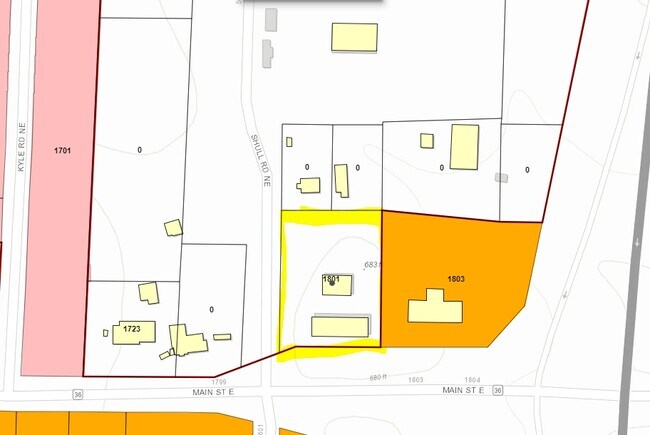
1801 Main St E
15-01-12-0-002-013.000
COM AT SW COR OF SW1/4 OF NE1/4 SEC 12, T7S, R4W, TH N 415'S, TH E 610'S TO TPOB, TH CONT E 228.5', TH SO 290'S, TH W ALG N R
Servicestation
Morgan
B and X Area of moderate flood hazard, usually the area between the limits of the 100-year and 500-year floods.
Alabama
2025
1.62 AC
2025
Alabama North Area
005305
Other Market Areas
2,400 SF
Decatur, AL
NEARBY LISTINGS FOR SALE OR LEASE
DEMOGRAPHICS near 1801 Main St E
1 mile
3 mile
5 mile
2025 Total Population
1,732
14,127
25,481
2030 Population
1,776
14,489
26,159
Pop Growth 2025-2030
+ 2.54%
+ 2.56%
+ 2.66%
Average Age
39
41
41
2025 Total Households
645
5,646
10,100
HH Growth 2025-2030
+ 2.64%
+ 2.59%
+ 2.68%
Median Household Inc
$111,619
$83,724
$89,994
Avg Household Size
2.60
2.50
2.50
2025 Avg HH Vehicles
2.00
2.00
2.00
Median Home Value
$233,474
$232,615
$247,172
Median Year Built
1991
1984
1986
Nearby Places
Map Layers
Map Styles
 Street
 Aerial
Layers
 Traffic
 Biking
Places
Listings with unknown addresses are not visible on the map
- Restaurants
- Banks
- Shops
- Fitness
- Groceries
PUBLIC TRANSPORTATION
AIRPORT
Huntsville International-Carl T Jones Field
Drive
Walk
Distance
Huntsville International-Carl T Jones Field
30 min
23.0 mi
Freight Ports
Port of Mobile
Drive
Walk
Distance
Port of Mobile
352 min
323.2 mi
Nearby Properties
Address
Land Use
TOTAL SIZE
Lot Size
Zoning
Address
Land Use
TOTAL SIZE
Lot Size
Zoning
79,148 SF
2.34 AC
Address
Land Use
TOTAL SIZE
Lot Size
Zoning
28,978 SF
6.50 AC
Address
Land Use
TOTAL SIZE
Lot Size
Zoning
155,504 SF
19 AC
Address
Land Use
TOTAL SIZE
Lot Size
Zoning
135,937 SF
27 AC
Address
Land Use
TOTAL SIZE
Lot Size
Zoning
115,286 SF
23 AC
Address
Land Use
TOTAL SIZE
Lot Size
Zoning
12,057 SF
2 AC
Address
Land Use
TOTAL SIZE
Lot Size
Zoning
12,973 SF
1.05 AC
Address
Land Use
TOTAL SIZE
Lot Size
Zoning
70,400 SF
7.60 AC
Address
Land Use
TOTAL SIZE
Lot Size
Zoning
5,074 SF
11 AC
Address
Land Use
TOTAL SIZE
Lot Size
Zoning
1,848 SF
4.80 AC
Address
Land Use
TOTAL SIZE
Lot Size
Zoning
282,610 SF
44 AC
Address
Land Use
TOTAL SIZE
Lot Size
Zoning
36,240 SF
10 AC
Address
Land Use
TOTAL SIZE
Lot Size
Zoning
16,204 SF
1.58 AC
Address
Land Use
TOTAL SIZE
Lot Size
Zoning
3,690 SF
5 AC
Address
Land Use
TOTAL SIZE
Lot Size
Zoning
73,090 SF
5.45 AC
Address
Land Use
TOTAL SIZE
Lot Size
Zoning
39,184 SF
1.80 AC
Address
Land Use
TOTAL SIZE
Lot Size
Zoning
16,650 SF
0.92 AC
Address
Land Use
TOTAL SIZE
Lot Size
Zoning
875 SF
2 AC
Address
Land Use
TOTAL SIZE
Lot Size
Zoning
18,812 SF
8 AC
Address
Land Use
TOTAL SIZE
Lot Size
Zoning
32,987 SF
1.20 AC
Address
Land Use
TOTAL SIZE
Lot Size
Zoning
1,042 SF
3.90 AC
Address
Land Use
TOTAL SIZE
Lot Size
Zoning
14,850 SF
1.48 AC
Address
Land Use
TOTAL SIZE
Lot Size
Zoning
17,640 SF
1.90 AC
Address
Land Use
TOTAL SIZE
Lot Size
Zoning
120,000 SF
19.30 AC
Address
Land Use
TOTAL SIZE
Lot Size
Zoning
7,037 SF
2.77 AC
Address
Land Use
TOTAL SIZE
Lot Size
Zoning
8,592 SF
13.70 AC
Address
Land Use
TOTAL SIZE
Lot Size
Zoning
16,000 SF
4.10 AC
Address
Land Use
TOTAL SIZE
Lot Size
Zoning
13,342 SF
4.70 AC
Address
Land Use
TOTAL SIZE
Lot Size
Zoning
1,218 SF
5.20 AC
Address
Land Use
TOTAL SIZE
Lot Size
Zoning
13,708 SF
2.90 AC
The World's #1 Commercial Real Estate Marketplace
Connect with us
© 2026 CoStar Group
The information above has been obtained from sources believed reliable. While we do not doubt its accuracy we have not verified it and make no guarantee, warranty or representation about it. It is your responsibility to independently confirm its accuracy and completeness. Any projections, opinions, assumptions, or estimates used are for example only and do not represent the current or future performance of the property. The value of this transaction to you depends on tax and other factors which should be evaluated by your tax, financial, and legal advisors. You and your advisors should conduct a careful, independent investigation of the property to determine to your satisfaction the suitability of the property for your needs.