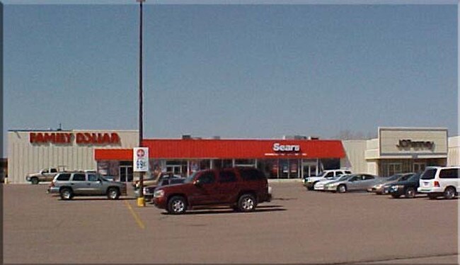
Property Record
1801 N Main St, Mitchell, SD 57301


Property Detail
1801 N Main St
15800-01600-103-60
SC-1, SC-2, SC-3, SC-4 & SC-5 EX SC-4A,SC-4-1,SC-4-2,SC-4-3 PARTLY IN NW1/4 15 & NE1/4 16 PLATTED
Commercialnec
DAVISON
32513
South Dakota
B and X Area of moderate flood hazard, usually the area between the limits of the 100-year and 500-year floods.
(null)
0
10.16 AC
2025
South Dakota Area
962700
Other Market Areas
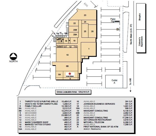
151,044 SF
Mitchell, SD
NEARBY LISTINGS FOR SALE OR LEASE
DEMOGRAPHICS near 1801 N Main St
1 mile
3 mile
5 mile
2025 Total Population
5,612
16,403
17,643
2030 Population
5,627
16,447
17,685
Pop Growth 2025-2030
+ 0.27%
+ 0.27%
+ 0.24%
Average Age
41
41
41
2025 Total Households
2,594
7,156
7,652
HH Growth 2025-2030
+ 0.35%
+ 0.27%
+ 0.24%
Median Household Inc
$42,458
$59,162
$59,999
Avg Household Size
2.00
2.20
2.20
2025 Avg HH Vehicles
2.00
2.00
2.00
Median Home Value
$168,015
$191,174
$195,337
Median Year Built
1967
1970
1971
Nearby Places
Map Layers
Map Styles
 Street
 Aerial
Transit
 Traffic
 Biking
Places
Listings with unknown addresses are not visible on the map
- Restaurants
- Banks
- Shops
- Fitness
- Groceries
SALE & LEASE HISTORY
LISTING DATE
SALE/LEASE

Sep 25, 2016
For Lease
Sep 24, 2016
For Sale
Sep 09, 2019
For Sale
May 14, 2020
For Lease
Nearby Properties
Address
Land Use
TOTAL SIZE
Lot Size
Zoning
Address
Land Use
TOTAL SIZE
Lot Size
Zoning
169,700 SF
14.02 AC
22211
Address
Land Use
TOTAL SIZE
Lot Size
Zoning
186,947 SF
24.11 AC
20111
Address
Land Use
TOTAL SIZE
Lot Size
Zoning
78,565 SF
2.46 AC
121310
Address
Land Use
TOTAL SIZE
Lot Size
Zoning
77,139 SF
24.21 AC
32213
Address
Land Use
TOTAL SIZE
Lot Size
Zoning
106,098 SF
8.56 AC
120211
Address
Land Use
TOTAL SIZE
Lot Size
Zoning
250,375 SF
19.87 AC
Address
Land Use
TOTAL SIZE
Lot Size
Zoning
84,712 SF
35.50 AC
111710
Address
Land Use
TOTAL SIZE
Lot Size
Zoning
199,734 SF
18.18 AC
22111
Address
Land Use
TOTAL SIZE
Lot Size
Zoning
256,818 SF
26.78 AC
32213
Address
Land Use
TOTAL SIZE
Lot Size
Zoning
4.11 AC
Address
Land Use
TOTAL SIZE
Lot Size
Zoning
147,940 SF
4.29 AC
Address
Land Use
TOTAL SIZE
Lot Size
Zoning
58,098 SF
3.19 AC
Address
Land Use
TOTAL SIZE
Lot Size
Zoning
59,862 SF
2.73 AC
Address
Land Use
TOTAL SIZE
Lot Size
Zoning
173,161 SF
37 AC
12711
Address
Land Use
TOTAL SIZE
Lot Size
Zoning
60,771 SF
2.61 AC
Address
Land Use
TOTAL SIZE
Lot Size
Zoning
80,578 SF
11.61 AC
20811
Address
Land Use
TOTAL SIZE
Lot Size
Zoning
189,974 SF
23.26 AC
12811
Address
Land Use
TOTAL SIZE
Lot Size
Zoning
49,600 SF
2.10 AC
Address
Land Use
TOTAL SIZE
Lot Size
Zoning
82,368 SF
3.97 AC
22412
Address
Land Use
TOTAL SIZE
Lot Size
Zoning
44,387 SF
2.08 AC
11911
Address
Land Use
TOTAL SIZE
Lot Size
Zoning
4.56 AC
Address
Land Use
TOTAL SIZE
Lot Size
Zoning
90,820 SF
8.68 AC
32812
Address
Land Use
TOTAL SIZE
Lot Size
Zoning
68,640 SF
4.70 AC
82710
Address
Land Use
TOTAL SIZE
Lot Size
Zoning
51,889 SF
1.72 AC
Address
Land Use
TOTAL SIZE
Lot Size
Zoning
45,825 SF
1.76 AC
21711
Address
Land Use
TOTAL SIZE
Lot Size
Zoning
55,482 SF
2.89 AC
21711
Address
Land Use
TOTAL SIZE
Lot Size
Zoning
75,800 SF
5.25 AC
21411
Address
Land Use
TOTAL SIZE
Lot Size
Zoning
54,617 SF
3.62 AC
21411
Address
Land Use
TOTAL SIZE
Lot Size
Zoning
77,272 SF
5.96 AC
Address
Land Use
TOTAL SIZE
Lot Size
Zoning
71,508 SF
6.31 AC
41212
The World's #1 Commercial Real Estate Marketplace
Connect with us
© 2026 CoStar Group
The information above has been obtained from sources believed reliable. While we do not doubt its accuracy we have not verified it and make no guarantee, warranty or representation about it. It is your responsibility to independently confirm its accuracy and completeness. Any projections, opinions, assumptions, or estimates used are for example only and do not represent the current or future performance of the property. The value of this transaction to you depends on tax and other factors which should be evaluated by your tax, financial, and legal advisors. You and your advisors should conduct a careful, independent investigation of the property to determine to your satisfaction the suitability of the property for your needs.