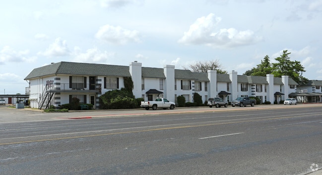
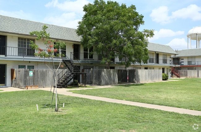
Property Record
1801 N Midland Dr, Midland, TX 79707

Save to a Folder
{{folder.Name}}
{{folder.ListingIds.length}} Properties
{{folder.ListingIds.length}} Property
Create a New Folder
Property Detail
1801 N Midland Dr
R000034-736
ACRES: 4.059 BLK:001 ALL ADDN: NOTTINGHAM SQUARE
Multifamilydwelling
Midland
MF1
Texas
2025
4.06 AC
2025
Midland & Odessa
010106
Other Market Areas
83,274 SF
Midland, TX
NEARBY LISTINGS FOR SALE OR LEASE
DEMOGRAPHICS near 1801 N Midland Dr
1 mile
3 mile
5 mile
2025 Total Population
15,992
88,083
140,669
2030 Population
17,663
96,678
155,061
Pop Growth 2025-2030
+ 10.45%
+ 9.76%
+ 10.23%
Average Age
37
36
36
2025 Total Households
6,424
33,469
51,777
HH Growth 2025-2030
+ 11.69%
+ 11.03%
+ 11.46%
Median Household Inc
$67,971
$92,542
$90,494
Avg Household Size
2.40
2.60
2.60
2025 Avg HH Vehicles
2.00
2.00
2.00
Median Home Value
$282,587
$319,721
$311,369
Median Year Built
1984
1983
1985
Nearby Places
Map Layers
Map Styles
 Street
 Aerial
Layers
 Traffic
 Biking
Places
Listings with unknown addresses are not visible on the map
- Restaurants
- Banks
- Shops
- Fitness
- Groceries
PUBLIC TRANSPORTATION
AIRPORT
Midland International Air And Space Port
Drive
Walk
Distance
Midland International Air And Space Port
16 min
9.7 mi
Freight Ports
Calhoun Port
Drive
Walk
Distance
Calhoun Port
530 min
475.4 mi
Nearby Properties
Address
Land Use
TOTAL SIZE
Lot Size
Zoning
Address
Land Use
TOTAL SIZE
Lot Size
Zoning
322,000 SF
24.88 AC
Address
Land Use
TOTAL SIZE
Lot Size
Zoning
25,575 SF
8.90 AC
Address
Land Use
TOTAL SIZE
Lot Size
Zoning
56,157 SF
18.19 AC
PDOC
Address
Land Use
TOTAL SIZE
Lot Size
Zoning
6,266 SF
17.84 AC
Address
Land Use
TOTAL SIZE
Lot Size
Zoning
2,339 SF
17.14 AC
Address
Land Use
TOTAL SIZE
Lot Size
Zoning
7,839 SF
12.92 AC
Address
Land Use
TOTAL SIZE
Lot Size
Zoning
2,453 SF
13.68 AC
Address
Land Use
TOTAL SIZE
Lot Size
Zoning
1,173 SF
14.05 AC
PDHD
Address
Land Use
TOTAL SIZE
Lot Size
Zoning
24,000 SF
11.87 AC
Address
Land Use
TOTAL SIZE
Lot Size
Zoning
2,196 SF
15.11 AC
PDHD
Address
Land Use
TOTAL SIZE
Lot Size
Zoning
7,793 SF
15.51 AC
Address
Land Use
TOTAL SIZE
Lot Size
Zoning
262,640 SF
13.71 AC
MF1
Address
Land Use
TOTAL SIZE
Lot Size
Zoning
28,750 SF
10.11 AC
Address
Land Use
TOTAL SIZE
Lot Size
Zoning
676 SF
11.40 AC
Address
Land Use
TOTAL SIZE
Lot Size
Zoning
7,200 SF
17.74 AC
MF1
Address
Land Use
TOTAL SIZE
Lot Size
Zoning
Address
Land Use
TOTAL SIZE
Lot Size
Zoning
15,000 SF
39.46 AC
PDHD
Address
Land Use
TOTAL SIZE
Lot Size
Zoning
600 SF
12.45 AC
MF1
Address
Land Use
TOTAL SIZE
Lot Size
Zoning
12,916 SF
0.71 AC
MF1
Address
Land Use
TOTAL SIZE
Lot Size
Zoning
44,784 SF
11.97 AC
MF1
Address
Land Use
TOTAL SIZE
Lot Size
Zoning
12,960 SF
15.93 AC
MF1
Address
Land Use
TOTAL SIZE
Lot Size
Zoning
2,049 SF
8.79 AC
MF1
Address
Land Use
TOTAL SIZE
Lot Size
Zoning
1,725 SF
11.98 AC
MF1
Address
Land Use
TOTAL SIZE
Lot Size
Zoning
109,881 SF
10.38 AC
MF1
Address
Land Use
TOTAL SIZE
Lot Size
Zoning
5,884 SF
22.97 AC
PDSC
Address
Land Use
TOTAL SIZE
Lot Size
Zoning
7,200 SF
10.68 AC
MF1
Address
Land Use
TOTAL SIZE
Lot Size
Zoning
209,680 SF
6.16 AC
Address
Land Use
TOTAL SIZE
Lot Size
Zoning
1,369 SF
8.69 AC
MF1
Address
Land Use
TOTAL SIZE
Lot Size
Zoning
1,678 SF
9.11 AC
MF1
Address
Land Use
TOTAL SIZE
Lot Size
Zoning
5,600 SF
10.18 AC
PDMX
The World's #1 Commercial Real Estate Marketplace
Connect with us
© 2026 CoStar Group
The information above has been obtained from sources believed reliable. While we do not doubt its accuracy we have not verified it and make no guarantee, warranty or representation about it. It is your responsibility to independently confirm its accuracy and completeness. Any projections, opinions, assumptions, or estimates used are for example only and do not represent the current or future performance of the property. The value of this transaction to you depends on tax and other factors which should be evaluated by your tax, financial, and legal advisors. You and your advisors should conduct a careful, independent investigation of the property to determine to your satisfaction the suitability of the property for your needs.