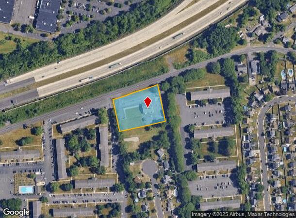
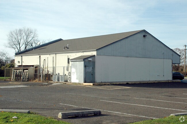
Property Record
1801 Newport Rd, Croydon, PA 19021

NEARBY LISTINGS FOR SALE OR LEASE
Property Detail
1801 Newport Rd
05-009-445-003
Zoning Plan
Storebuilding
1.44A S S APPL 276
X
Bucks
42017C0507K
Pennsylvania
2024
1.44 AC
2025
Lower Bucks County
100307
Philadelphia
3,000 SF
Philadelphia-Camden-Wilmington, PA-NJ-DE-MD
DEMOGRAPHICS near 1801 Newport Rd
1 mile
3 mile
5 mile
2024 Total Population
12,308
81,983
244,537
2029 Population
12,218
82,006
243,815
Pop Growth 2024-2029
(0.73%)
+ 0.03%
(0.30%)
Average Age
41
41
41
2024 Total Households
4,673
31,484
92,312
HH Growth 2024-2029
(0.79%)
+ 0.02%
(0.34%)
Median Household Inc
$65,275
$73,813
$79,962
Avg Household Size
2.60
2.50
2.60
2024 Avg HH Vehicles
2.00
2.00
2.00
Median Home Value
$250,730
$265,706
$264,619
Median Year Built
1966
1967
1965
Nearby Places
Map Layers
Map Styles
 Street
 Aerial
Transit
 Traffic
 Biking
Places
Listings with unknown addresses are not visible on the map
- Restaurants
- Banks
- Shops
- Fitness
- Groceries
PUBLIC TRANSPORTATION
COMMUTER RAIL
Croydon (R7 - Southeastern Pennsylvania Transportation Authority Regional Rail (SEPTA Regional Rail))
Drive
Walk
Distance
Croydon (R7 - Southeastern Pennsylvania Transportation Authority Regional Rail (SEPTA Regional Rail))
3 min
20 min
1.1 mi
Bristol (R7 - Southeastern Pennsylvania Transportation Authority Regional Rail (SEPTA Regional Rail))
Drive
Walk
Distance
Bristol (R7 - Southeastern Pennsylvania Transportation Authority Regional Rail (SEPTA Regional Rail))
8 min
3.1 mi
AIRPORT
Trenton Mercer
Drive
Walk
Distance
Trenton Mercer
27 min
15.9 mi
Philadelphia International
Drive
Walk
Distance
Philadelphia International
46 min
29.1 mi
Freight Ports
Port of Philadelphia
Drive
Walk
Distance
Port of Philadelphia
26 min
15.4 mi
Nearby Properties
Address
Land Use
TOTAL SIZE
Lot Size
Zoning
Address
Land Use
TOTAL SIZE
Lot Size
Zoning
Address
Land Use
TOTAL SIZE
Lot Size
Zoning
11 AC
TRN
Address
Land Use
TOTAL SIZE
Lot Size
Zoning
15.09 AC
I-1
Address
Land Use
TOTAL SIZE
Lot Size
Zoning
Address
Land Use
TOTAL SIZE
Lot Size
Zoning
8.60 AC
R-1
Address
Land Use
TOTAL SIZE
Lot Size
Zoning
2.46 AC
W-1
Address
Land Use
TOTAL SIZE
Lot Size
Zoning
242 AC
OS-1
Address
Land Use
TOTAL SIZE
Lot Size
Zoning
38,590 SF
1.82 AC
TRN
Address
Land Use
TOTAL SIZE
Lot Size
Zoning
Address
Land Use
TOTAL SIZE
Lot Size
Zoning
3,456 SF
4.88 AC
TRN
Address
Land Use
TOTAL SIZE
Lot Size
Zoning
11,280 SF
26.16 AC
R3
Address
Land Use
TOTAL SIZE
Lot Size
Zoning
Address
Land Use
TOTAL SIZE
Lot Size
Zoning
66.09 AC
I-2
Address
Land Use
TOTAL SIZE
Lot Size
Zoning
34,920 SF
38 AC
CD
Address
Land Use
TOTAL SIZE
Lot Size
Zoning
31,497 SF
21.50 AC
1-2
Address
Land Use
TOTAL SIZE
Lot Size
Zoning
30.79 AC
I-2
Address
Land Use
TOTAL SIZE
Lot Size
Zoning
150,000 SF
21.46 AC
R3
Address
Land Use
TOTAL SIZE
Lot Size
Zoning
8.19 AC
I-P
Address
Land Use
TOTAL SIZE
Lot Size
Zoning
4.49 AC
I-P
Address
Land Use
TOTAL SIZE
Lot Size
Zoning
1.30 AC
TC-2
Address
Land Use
TOTAL SIZE
Lot Size
Zoning
19.95 AC
CD
Address
Land Use
TOTAL SIZE
Lot Size
Zoning
8,320 SF
1.18 AC
Address
Land Use
TOTAL SIZE
Lot Size
Zoning
242,550 SF
24.32 AC
PI
Address
Land Use
TOTAL SIZE
Lot Size
Zoning
3,358 SF
1.75 AC
TRN
Address
Land Use
TOTAL SIZE
Lot Size
Zoning
3.11 AC
Address
Land Use
TOTAL SIZE
Lot Size
Zoning
0.40 AC
TRN
Address
Land Use
TOTAL SIZE
Lot Size
Zoning
10,779 SF
19.07 AC
CD
Address
Land Use
TOTAL SIZE
Lot Size
Zoning
242,550 SF
24.18 AC
PI
Address
Land Use
TOTAL SIZE
Lot Size
Zoning
125,307 SF
31.79 AC
VC
Address
Land Use
TOTAL SIZE
Lot Size
Zoning
2,800 SF
1.29 AC
R7.5
The World's #1 Commercial Real Estate Marketplace
Connect with us
© 2026 CoStar Group
The information above has been obtained from sources believed reliable. While we do not doubt its accuracy we have not verified it and make no guarantee, warranty or representation about it. It is your responsibility to independently confirm its accuracy and completeness. Any projections, opinions, assumptions, or estimates used are for example only and do not represent the current or future performance of the property. The value of this transaction to you depends on tax and other factors which should be evaluated by your tax, financial, and legal advisors. You and your advisors should conduct a careful, independent investigation of the property to determine to your satisfaction the suitability of the property for your needs.