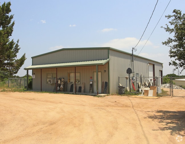
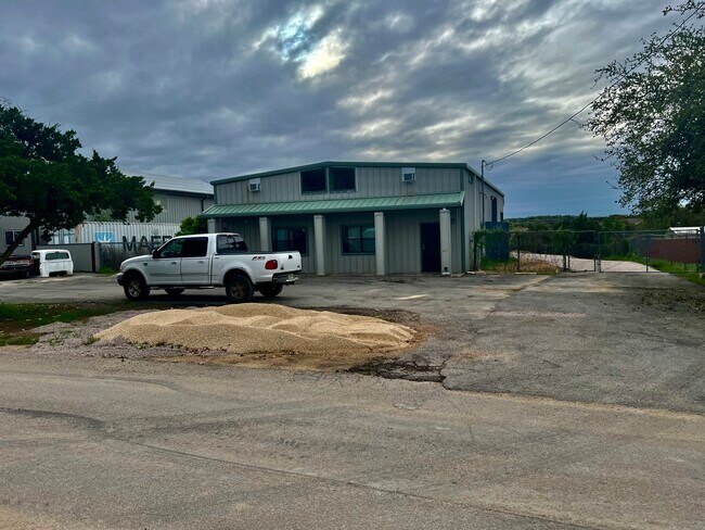
Property Record
1801 Pyramid Dr, Austin, TX 78734

Property Detail
1801 Pyramid Dr
Austin-Round Rock-San Marcos, TX
LOT 29 CARDINAL HILLS ESTATES UNIT 13
147331
Travis
Warehouse
Texas
B and X Area of moderate flood hazard, usually the area between the limits of the 100-year and 500-year floods.
29
2025
0.42 AC
2025
Southwest
031500
Austin
3,000 SF
NEARBY LISTINGS FOR SALE OR LEASE
DEMOGRAPHICS near 1801 Pyramid Dr
1 mile
3 mile
5 mile
2024 Total Population
4,749
30,764
69,178
2029 Population
5,013
32,208
72,625
Pop Growth 2024-2029
+ 5.56%
+ 4.69%
+ 4.98%
Average Age
42
43
44
2024 Total Households
1,936
11,725
26,759
HH Growth 2024-2029
+ 6.30%
+ 5.52%
+ 5.76%
Median Household Inc
$102,867
$153,734
$151,844
Avg Household Size
2.50
2.60
2.60
2024 Avg HH Vehicles
2.00
2.00
2.00
Median Home Value
$704,343
$787,928
$815,176
Median Year Built
2002
2003
2005
Nearby Places
Map Layers
Map Styles
 Street
 Aerial
Transit
 Traffic
 Biking
Places
Listings with unknown addresses are not visible on the map
- Restaurants
- Banks
- Shops
- Fitness
- Groceries
PUBLIC TRANSPORTATION
AIRPORT
Austin-Bergstrom International
Drive
Walk
Distance
Austin-Bergstrom International
48 min
29.0 mi
SALE & LEASE HISTORY
LISTING DATE
SALE/LEASE

Mar 27, 2024
For Lease
Nearby Properties
Address
Land Use
TOTAL SIZE
Lot Size
Zoning
Address
Land Use
TOTAL SIZE
Lot Size
Zoning
629,551 SF
53.66 AC
Address
Land Use
TOTAL SIZE
Lot Size
Zoning
296,448 SF
37.39 AC
Address
Land Use
TOTAL SIZE
Lot Size
Zoning
115,358 SF
21.04 AC
Address
Land Use
TOTAL SIZE
Lot Size
Zoning
182,225 SF
30.33 AC
Address
Land Use
TOTAL SIZE
Lot Size
Zoning
136,518 SF
27.59 AC
Address
Land Use
TOTAL SIZE
Lot Size
Zoning
199,974 SF
10.63 AC
Address
Land Use
TOTAL SIZE
Lot Size
Zoning
129,999 SF
9.88 AC
Address
Land Use
TOTAL SIZE
Lot Size
Zoning
34,756 SF
39.03 AC
Address
Land Use
TOTAL SIZE
Lot Size
Zoning
74.46 AC
Address
Land Use
TOTAL SIZE
Lot Size
Zoning
104,303 SF
15.45 AC
Address
Land Use
TOTAL SIZE
Lot Size
Zoning
460.44 AC
Address
Land Use
TOTAL SIZE
Lot Size
Zoning
433.77 AC
Address
Land Use
TOTAL SIZE
Lot Size
Zoning
60,907 SF
8.50 AC
Address
Land Use
TOTAL SIZE
Lot Size
Zoning
39,227 SF
7.12 AC
Address
Land Use
TOTAL SIZE
Lot Size
Zoning
123,300 SF
7.95 AC
Address
Land Use
TOTAL SIZE
Lot Size
Zoning
12,859 SF
36.56 AC
Address
Land Use
TOTAL SIZE
Lot Size
Zoning
100,000 SF
4.62 AC
Address
Land Use
TOTAL SIZE
Lot Size
Zoning
31.43 AC
Address
Land Use
TOTAL SIZE
Lot Size
Zoning
56,010 SF
4.61 AC
Address
Land Use
TOTAL SIZE
Lot Size
Zoning
1,440 SF
301.45 AC
Address
Land Use
TOTAL SIZE
Lot Size
Zoning
85,756 SF
5.56 AC
Address
Land Use
TOTAL SIZE
Lot Size
Zoning
487.49 AC
Address
Land Use
TOTAL SIZE
Lot Size
Zoning
Address
Land Use
TOTAL SIZE
Lot Size
Zoning
90,984 SF
32.06 AC
Address
Land Use
TOTAL SIZE
Lot Size
Zoning
22.42 AC
Address
Land Use
TOTAL SIZE
Lot Size
Zoning
58,640 SF
Address
Land Use
TOTAL SIZE
Lot Size
Zoning
14.79 AC
Address
Land Use
TOTAL SIZE
Lot Size
Zoning
46.83 AC
Address
Land Use
TOTAL SIZE
Lot Size
Zoning
158.53 AC
Address
Land Use
TOTAL SIZE
Lot Size
Zoning
48,524 SF
2.45 AC
The World's #1 Commercial Real Estate Marketplace
Connect with us
© 2026 CoStar Group
The information above has been obtained from sources believed reliable. While we do not doubt its accuracy we have not verified it and make no guarantee, warranty or representation about it. It is your responsibility to independently confirm its accuracy and completeness. Any projections, opinions, assumptions, or estimates used are for example only and do not represent the current or future performance of the property. The value of this transaction to you depends on tax and other factors which should be evaluated by your tax, financial, and legal advisors. You and your advisors should conduct a careful, independent investigation of the property to determine to your satisfaction the suitability of the property for your needs.