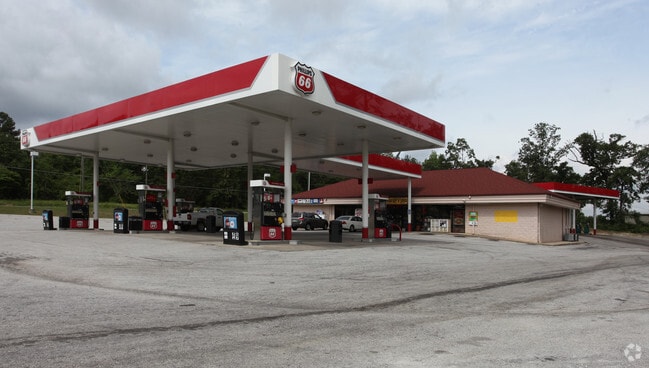
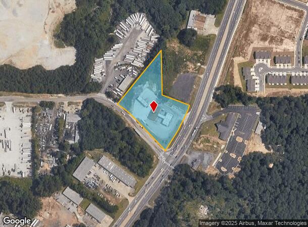
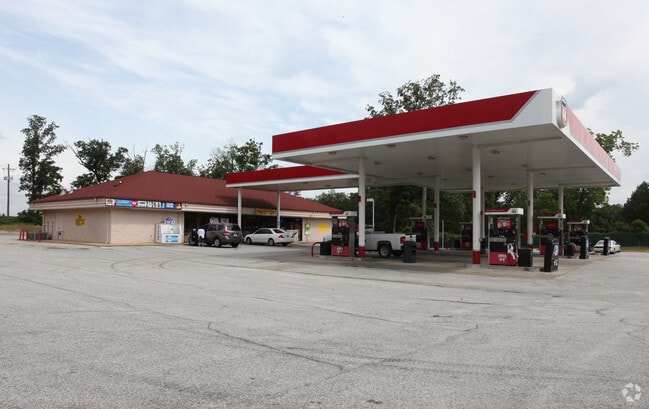
Property Record
1801 Rock Chapel Rd, Lithonia, GA 30058
NEARBY LISTINGS FOR SALE OR LEASE
Property Detail
1801 Rock Chapel Rd
16-188-01-003
354 X 336 X 107 X 484 X 370 X 183 3.27AC 12-19-88
Supermarket
DeKalb
X
Georgia
13247C0080D
3
2025
3.27 AC
2025
Stone Mtn/Clarkston
023315
Atlanta
3,872 SF
Atlanta-Sandy Springs-Roswell, GA
DEMOGRAPHICS near 1801 Rock Chapel Rd
1 Mile
3 Mile
5 Mile
2024 Total Population
1,846
39,178
126,744
2029 Population
1,836
39,331
127,575
Pop Growth 2024-2029
(0.54%)
+ 0.39%
+ 0.66%
Average Age
38
38
38
2024 Total Households
586
13,670
44,946
HH Growth 2024-2029
(0.51%)
+ 0.40%
+ 0.49%
Median Household Inc
$83,980
$63,646
$66,343
Avg Household Size
3.10
2.80
2.70
2024 Avg HH Vehicles
2.00
2.00
2.00
Median Home Value
$261,989
$207,944
$212,399
Median Year Built
2002
1995
1993
Nearby Places
Map Layers
Map Styles
 Street
 Aerial
- Restaurants
- Banks
- Shops
- Fitness
- Groceries
PUBLIC TRANSPORTATION
AIRPORT
Hartsfield - Jackson Atlanta International
DRIVE
WALK
Distance
Hartsfield - Jackson Atlanta International
37 min
25.7 mi
Freight Ports
Georgia Ports - Savannah
DRIVE
WALK
Distance
Georgia Ports - Savannah
285 min
244.9 mi
Nearby Properties
Address
Land Use
TOTAL SIZE
Lot Size
Zoning
Address
Land Use
TOTAL SIZE
Lot Size
Zoning
614,505 SF
97.30 AC
Address
Land Use
TOTAL SIZE
Lot Size
Zoning
764,622 SF
48.38 AC
M
Address
Land Use
TOTAL SIZE
Lot Size
Zoning
240,744 SF
23.93 AC
RM100
Address
Land Use
TOTAL SIZE
Lot Size
Zoning
235,521 SF
15.36 AC
RM75
Address
Land Use
TOTAL SIZE
Lot Size
Zoning
314,474 SF
24.04 AC
RM75
Address
Land Use
TOTAL SIZE
Lot Size
Zoning
405,288 SF
28.89 AC
C1
Address
Land Use
TOTAL SIZE
Lot Size
Zoning
7,384 SF
15.80 AC
M
Address
Land Use
TOTAL SIZE
Lot Size
Zoning
215,422 SF
33.84 AC
M
Address
Land Use
TOTAL SIZE
Lot Size
Zoning
227,648 SF
14.56 AC
X
Address
Land Use
TOTAL SIZE
Lot Size
Zoning
124,591 SF
13.89 AC
C2
Address
Land Use
TOTAL SIZE
Lot Size
Zoning
485,258 SF
23.61 AC
M
Address
Land Use
TOTAL SIZE
Lot Size
Zoning
18,099 SF
1,412.45 AC
M2
Address
Land Use
TOTAL SIZE
Lot Size
Zoning
207,446 SF
12.21 AC
M
Address
Land Use
TOTAL SIZE
Lot Size
Zoning
48,531 SF
10.01 AC
C1
Address
Land Use
TOTAL SIZE
Lot Size
Zoning
26,760 SF
2.50 AC
C1
Address
Land Use
TOTAL SIZE
Lot Size
Zoning
253,861 SF
19.28 AC
X
Address
Land Use
TOTAL SIZE
Lot Size
Zoning
38.94 AC
M
Address
Land Use
TOTAL SIZE
Lot Size
Zoning
142,160 SF
9.50 AC
M
Address
Land Use
TOTAL SIZE
Lot Size
Zoning
96,679 SF
8.38 AC
RM75
Address
Land Use
TOTAL SIZE
Lot Size
Zoning
27,542 SF
1.75 AC
C1
Address
Land Use
TOTAL SIZE
Lot Size
Zoning
150,000 SF
13.24 AC
M
Address
Land Use
TOTAL SIZE
Lot Size
Zoning
94,220 SF
4.60 AC
RM75
Address
Land Use
TOTAL SIZE
Lot Size
Zoning
21.53 AC
M
Address
Land Use
TOTAL SIZE
Lot Size
Zoning
19,514 SF
1.32 AC
C1
Address
Land Use
TOTAL SIZE
Lot Size
Zoning
94,296 SF
8.94 AC
Address
Land Use
TOTAL SIZE
Lot Size
Zoning
112,474 SF
9.20 AC
M
Address
Land Use
TOTAL SIZE
Lot Size
Zoning
94,581 SF
5.58 AC
M
Address
Land Use
TOTAL SIZE
Lot Size
Zoning
55,070 SF
3.75 AC
X
Address
Land Use
TOTAL SIZE
Lot Size
Zoning
98,676 SF
17.75 AC
C1
Address
Land Use
TOTAL SIZE
Lot Size
Zoning
99,876 SF
11.81 AC
M2
The World's #1 Commercial Real Estate Marketplace
Connect with us
© 2025 CoStar Group
The information above has been obtained from sources believed reliable. While we do not doubt its accuracy we have not verified it and make no guarantee, warranty or representation about it. It is your responsibility to independently confirm its accuracy and completeness. Any projections, opinions, assumptions, or estimates used are for example only and do not represent the current or future performance of the property. The value of this transaction to you depends on tax and other factors which should be evaluated by your tax, financial, and legal advisors. You and your advisors should conduct a careful, independent investigation of the property to determine to your satisfaction the suitability of the property for your needs.