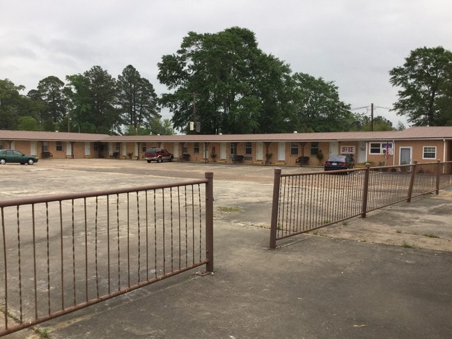
Property Record
1801 S 5Th St, Leesville, LA 71446

Save to a Folder
{{folder.Name}}
{{folder.ListingIds.length}} Properties
{{folder.ListingIds.length}} Property
Create a New Folder
Property Detail
1801 S 5Th St
011-181-3635
REDESCRIBED; T2NR9W- SEC 26, TRACT SITUATED IN THE SWNW; COMM AT THE INTERSECTION OF THE S LINE OF SWNW & THE E R/W OF HWY 171; N 11 DEG 25' 32 E, 18 5.94FT BEING THE POB; N 11 DEG 25' 32 E, 299.42 FT; S 78 DEG 02' 30 E, 159.46 FT; S 11 DEG 25' 44 W,
Storebuilding
Vernon
B and X Area of moderate flood hazard, usually the area between the limits of the 100-year and 500-year floods.
Louisiana
2025
1.80 AC
2025
Louisiana North Area
950501
Other Market Areas
NEARBY LISTINGS FOR SALE OR LEASE
-
-
View all Leesville listings for sale on LoopNet.com
DEMOGRAPHICS near 1801 S 5Th St
1 mile
3 mile
5 mile
2025 Total Population
1,483
9,299
17,371
2030 Population
1,443
9,096
16,899
Pop Growth 2025-2030
(2.70%)
(2.18%)
(2.72%)
Average Age
38
38
35
2025 Total Households
627
4,002
7,306
HH Growth 2025-2030
(2.39%)
(1.85%)
(2.79%)
Median Household Inc
$47,000
$43,867
$52,673
Avg Household Size
2.20
2.30
2.30
2025 Avg HH Vehicles
1.00
1.00
2.00
Median Home Value
$144,954
$139,470
$155,169
Median Year Built
1978
1977
1983
Nearby Places
Map Layers
Map Styles
 Street
 Aerial
Layers
 Traffic
 Biking
Places
Listings with unknown addresses are not visible on the map
- Restaurants
- Banks
- Shops
- Fitness
- Groceries
Nearby Properties
Address
Land Use
TOTAL SIZE
Lot Size
Zoning
Address
Land Use
TOTAL SIZE
Lot Size
Zoning
Address
Land Use
TOTAL SIZE
Lot Size
Zoning
Address
Land Use
TOTAL SIZE
Lot Size
Zoning
Address
Land Use
TOTAL SIZE
Lot Size
Zoning
Address
Land Use
TOTAL SIZE
Lot Size
Zoning
Address
Land Use
TOTAL SIZE
Lot Size
Zoning
Address
Land Use
TOTAL SIZE
Lot Size
Zoning
Address
Land Use
TOTAL SIZE
Lot Size
Zoning
Address
Land Use
TOTAL SIZE
Lot Size
Zoning
Address
Land Use
TOTAL SIZE
Lot Size
Zoning
Address
Land Use
TOTAL SIZE
Lot Size
Zoning
Address
Land Use
TOTAL SIZE
Lot Size
Zoning
2.70 AC
Address
Land Use
TOTAL SIZE
Lot Size
Zoning
0.22 AC
Address
Land Use
TOTAL SIZE
Lot Size
Zoning
Address
Land Use
TOTAL SIZE
Lot Size
Zoning
2.56 AC
Address
Land Use
TOTAL SIZE
Lot Size
Zoning
Address
Land Use
TOTAL SIZE
Lot Size
Zoning
1.84 AC
Address
Land Use
TOTAL SIZE
Lot Size
Zoning
Address
Land Use
TOTAL SIZE
Lot Size
Zoning
Address
Land Use
TOTAL SIZE
Lot Size
Zoning
Address
Land Use
TOTAL SIZE
Lot Size
Zoning
Address
Land Use
TOTAL SIZE
Lot Size
Zoning
The World's #1 Commercial Real Estate Marketplace
Connect with us
© 2026 CoStar Group
The information above has been obtained from sources believed reliable. While we do not doubt its accuracy we have not verified it and make no guarantee, warranty or representation about it. It is your responsibility to independently confirm its accuracy and completeness. Any projections, opinions, assumptions, or estimates used are for example only and do not represent the current or future performance of the property. The value of this transaction to you depends on tax and other factors which should be evaluated by your tax, financial, and legal advisors. You and your advisors should conduct a careful, independent investigation of the property to determine to your satisfaction the suitability of the property for your needs.