Property Record
1801 S Rollie Ave, Fort Lupton, CO 80621

Save to a Folder
{{folder.Name}}
{{folder.ListingIds.length}} Properties
{{folder.ListingIds.length}} Property
Create a New Folder
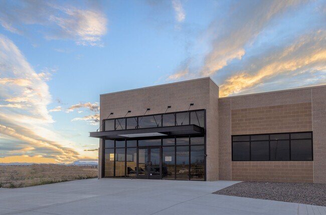
Property Detail
1801 S Rollie Ave
R6780332
PT W2E2NW4 & E2W2NW4 17-1-66 EXC BEG 1026.25E OF NW COR NW4 S567 E310 N567 W310 TO BEG EXC PT NW4 17 1 66 BEG NW COR THENCE E 1336 TO POB S 537 E 310 N 537 W 310 TO TRUE POB
Industrialgeneral
Weld
B and X Area of moderate flood hazard, usually the area between the limits of the 100-year and 500-year floods.
Colorado
2025
59.19 AC
2026
Weld County
001905
Denver
198,777 SF
Greeley, CO
NEARBY LISTINGS FOR SALE OR LEASE
DEMOGRAPHICS near 1801 S Rollie Ave
1 mile
3 mile
5 mile
2025 Total Population
398
11,496
37,680
2030 Population
451
12,896
40,882
Pop Growth 2025-2030
+ 13.32%
+ 12.18%
+ 8.50%
Average Age
41
39
38
2025 Total Households
138
3,889
12,234
HH Growth 2025-2030
+ 13.04%
+ 12.47%
+ 8.84%
Median Household Inc
$97,221
$76,162
$91,417
Avg Household Size
2.90
2.90
3.00
2025 Avg HH Vehicles
3.00
2.00
2.00
Median Home Value
$580,508
$399,383
$457,209
Median Year Built
2001
1990
1993
Nearby Places
Map Layers
Map Styles
 Street
 Aerial
Layers
 Traffic
 Biking
Places
Listings with unknown addresses are not visible on the map
- Restaurants
- Banks
- Shops
- Fitness
- Groceries
PUBLIC TRANSPORTATION
AIRPORT
Denver International
Drive
Walk
Distance
Denver International
40 min
26.8 mi
Nearby Properties
Address
Land Use
TOTAL SIZE
Lot Size
Zoning
Address
Land Use
TOTAL SIZE
Lot Size
Zoning
533,981 SF
112.40 AC
Address
Land Use
TOTAL SIZE
Lot Size
Zoning
124,238 SF
62.61 AC
Address
Land Use
TOTAL SIZE
Lot Size
Zoning
274,367 SF
65.77 AC
Address
Land Use
TOTAL SIZE
Lot Size
Zoning
217,236 SF
55.97 AC
Address
Land Use
TOTAL SIZE
Lot Size
Zoning
276,393 SF
40 AC
Address
Land Use
TOTAL SIZE
Lot Size
Zoning
70,131 SF
11.43 AC
Address
Land Use
TOTAL SIZE
Lot Size
Zoning
55,286 SF
59.13 AC
Address
Land Use
TOTAL SIZE
Lot Size
Zoning
60,400 SF
19.12 AC
Address
Land Use
TOTAL SIZE
Lot Size
Zoning
37,126 SF
33.04 AC
Address
Land Use
TOTAL SIZE
Lot Size
Zoning
103,400 SF
15.15 AC
Address
Land Use
TOTAL SIZE
Lot Size
Zoning
153,874 SF
8.92 AC
Address
Land Use
TOTAL SIZE
Lot Size
Zoning
36,200 SF
25 AC
Address
Land Use
TOTAL SIZE
Lot Size
Zoning
78,700 SF
23.10 AC
Address
Land Use
TOTAL SIZE
Lot Size
Zoning
57,450 SF
30 AC
Address
Land Use
TOTAL SIZE
Lot Size
Zoning
96,798 SF
16.14 AC
Address
Land Use
TOTAL SIZE
Lot Size
Zoning
238,735 SF
21.18 AC
Address
Land Use
TOTAL SIZE
Lot Size
Zoning
52,593 SF
15 AC
Address
Land Use
TOTAL SIZE
Lot Size
Zoning
58,165 SF
5.45 AC
Address
Land Use
TOTAL SIZE
Lot Size
Zoning
30,000 SF
5.86 AC
Address
Land Use
TOTAL SIZE
Lot Size
Zoning
30,000 SF
5.86 AC
Address
Land Use
TOTAL SIZE
Lot Size
Zoning
42,500 SF
7.73 AC
Address
Land Use
TOTAL SIZE
Lot Size
Zoning
77,552 SF
10 AC
Address
Land Use
TOTAL SIZE
Lot Size
Zoning
23,763 SF
5.86 AC
Address
Land Use
TOTAL SIZE
Lot Size
Zoning
81,122 SF
13 AC
Address
Land Use
TOTAL SIZE
Lot Size
Zoning
26,065 SF
20 AC
Address
Land Use
TOTAL SIZE
Lot Size
Zoning
9,100 SF
51.39 AC
Address
Land Use
TOTAL SIZE
Lot Size
Zoning
38,880 SF
3.90 AC
Address
Land Use
TOTAL SIZE
Lot Size
Zoning
Address
Land Use
TOTAL SIZE
Lot Size
Zoning
18,505 SF
16.92 AC
The World's #1 Commercial Real Estate Marketplace
Connect with us
© 2026 CoStar Group
The information above has been obtained from sources believed reliable. While we do not doubt its accuracy we have not verified it and make no guarantee, warranty or representation about it. It is your responsibility to independently confirm its accuracy and completeness. Any projections, opinions, assumptions, or estimates used are for example only and do not represent the current or future performance of the property. The value of this transaction to you depends on tax and other factors which should be evaluated by your tax, financial, and legal advisors. You and your advisors should conduct a careful, independent investigation of the property to determine to your satisfaction the suitability of the property for your needs.