Property Record
1801 Tamiami Trl, Punta Gorda, FL 33950

NEARBY LISTINGS FOR SALE OR LEASE
Property Detail
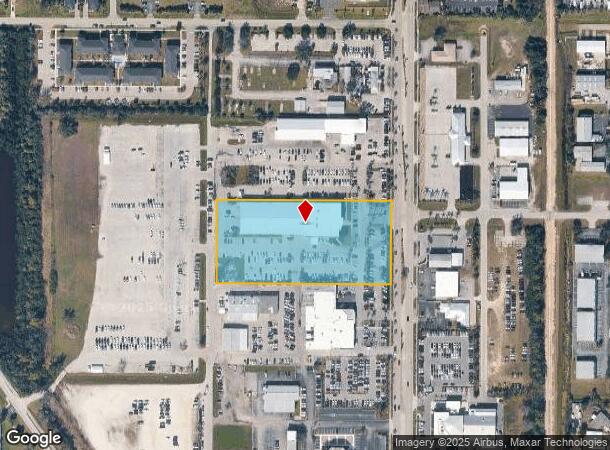
1801 Tamiami Trl
412307326006
Acreage
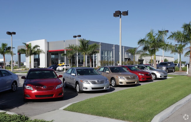
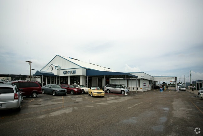
Vehiclerentalsvehiclesales
07 41 23 P-22 2A M/L FRONTING 145FT ON HWY 41 & EXT AT RIGHT ANGLES W 610FT BEING PART OF E1/2 OF NE1/4 OF SW1/4 & LYING 610FT S OF N LINE THEREOF 2182/1405 ZZZ 074123 P23 7-41-23 2A M/L P-23 FRONTING 145 FT ON HWY 41 & EXT AT RIGHTANGLES W610F
AE
Charlotte
12015C0241G
Florida
2024
4.06 AC
2025
Charlotte County
010301
Southwest Florida
48,028 SF
Punta Gorda, FL
DEMOGRAPHICS near 1801 Tamiami Trl
1 Mile
3 Mile
5 Mile
2024 Total Population
6,550
26,656
55,414
2029 Population
7,946
32,163
66,704
Pop Growth 2024-2029
+ 21.31%
+ 20.66%
+ 20.37%
Average Age
54
59
56
2024 Total Households
3,250
13,458
26,754
HH Growth 2024-2029
+ 21.51%
+ 20.80%
+ 20.68%
Median Household Inc
$49,630
$64,081
$58,538
Avg Household Size
1.90
1.90
2.00
2024 Avg HH Vehicles
2.00
2.00
2.00
Median Home Value
$282,009
$433,400
$283,612
Median Year Built
1989
1992
1989
Nearby Places
Map Layers
Map Styles
 Street
 Aerial
- Restaurants
- Banks
- Shops
- Fitness
- Groceries
PUBLIC TRANSPORTATION
AIRPORT
Punta Gorda
DRIVE
WALK
Distance
Punta Gorda
8 min
3.9 mi
Freight Ports
Port Manatee
DRIVE
WALK
Distance
Port Manatee
88 min
73.5 mi
Nearby Properties
Address
Land Use
TOTAL SIZE
Lot Size
Zoning
Address
Land Use
TOTAL SIZE
Lot Size
Zoning
333,027 SF
9.79 AC
CHRW
Address
Land Use
TOTAL SIZE
Lot Size
Zoning
349,844 SF
78.47 AC
P
Address
Land Use
TOTAL SIZE
Lot Size
Zoning
164,121 SF
44.20 AC
ECAP
Address
Land Use
TOTAL SIZE
Lot Size
Zoning
77,154 SF
10.30 AC
CC
Address
Land Use
TOTAL SIZE
Lot Size
Zoning
161,439 SF
171 AC
RE1
Address
Land Use
TOTAL SIZE
Lot Size
Zoning
265,949 SF
22.80 AC
PD-CC
Address
Land Use
TOTAL SIZE
Lot Size
Zoning
345,043 SF
33.12 AC
ECAP
Address
Land Use
TOTAL SIZE
Lot Size
Zoning
47,443 SF
7.94 AC
CC
Address
Land Use
TOTAL SIZE
Lot Size
Zoning
62,415 SF
281.65 AC
ECAP
Address
Land Use
TOTAL SIZE
Lot Size
Zoning
114,417 SF
4.36 AC
GM-15
Address
Land Use
TOTAL SIZE
Lot Size
Zoning
15,253 SF
13.27 AC
P
Address
Land Use
TOTAL SIZE
Lot Size
Zoning
198,916 SF
25.79 AC
HC
Address
Land Use
TOTAL SIZE
Lot Size
Zoning
208,560 SF
36.69 AC
PD-GM
Address
Land Use
TOTAL SIZE
Lot Size
Zoning
385,350 SF
374.81 AC
ECAP
Address
Land Use
TOTAL SIZE
Lot Size
Zoning
142,812 SF
7.89 AC
HC
Address
Land Use
TOTAL SIZE
Lot Size
Zoning
6,313 SF
15.49 AC
P
Address
Land Use
TOTAL SIZE
Lot Size
Zoning
73,095 SF
5 AC
NC
Address
Land Use
TOTAL SIZE
Lot Size
Zoning
44,185 SF
1.22 AC
CC
Address
Land Use
TOTAL SIZE
Lot Size
Zoning
25,356 SF
1.40 AC
CC
Address
Land Use
TOTAL SIZE
Lot Size
Zoning
96,845 SF
17.62 AC
HC
Address
Land Use
TOTAL SIZE
Lot Size
Zoning
82,379 SF
0.88 AC
CC
Address
Land Use
TOTAL SIZE
Lot Size
Zoning
12,159 SF
0.56 AC
CC
Address
Land Use
TOTAL SIZE
Lot Size
Zoning
24,880 SF
84.50 AC
PKR
Address
Land Use
TOTAL SIZE
Lot Size
Zoning
43,755 SF
8.19 AC
CC
Address
Land Use
TOTAL SIZE
Lot Size
Zoning
30,472 SF
3.19 AC
NR-10
Address
Land Use
TOTAL SIZE
Lot Size
Zoning
30,940 SF
0.42 AC
NC
Address
Land Use
TOTAL SIZE
Lot Size
Zoning
68,492 SF
6.38 AC
HC
Address
Land Use
TOTAL SIZE
Lot Size
Zoning
11.50 AC
CHRW
Address
Land Use
TOTAL SIZE
Lot Size
Zoning
63,902 SF
5.87 AC
HC
The World's #1 Commercial Real Estate Marketplace
Connect with us
© 2026 CoStar Group
The information above has been obtained from sources believed reliable. While we do not doubt its accuracy we have not verified it and make no guarantee, warranty or representation about it. It is your responsibility to independently confirm its accuracy and completeness. Any projections, opinions, assumptions, or estimates used are for example only and do not represent the current or future performance of the property. The value of this transaction to you depends on tax and other factors which should be evaluated by your tax, financial, and legal advisors. You and your advisors should conduct a careful, independent investigation of the property to determine to your satisfaction the suitability of the property for your needs.