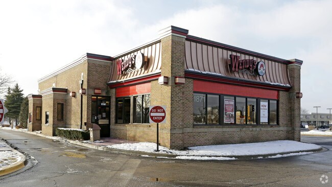
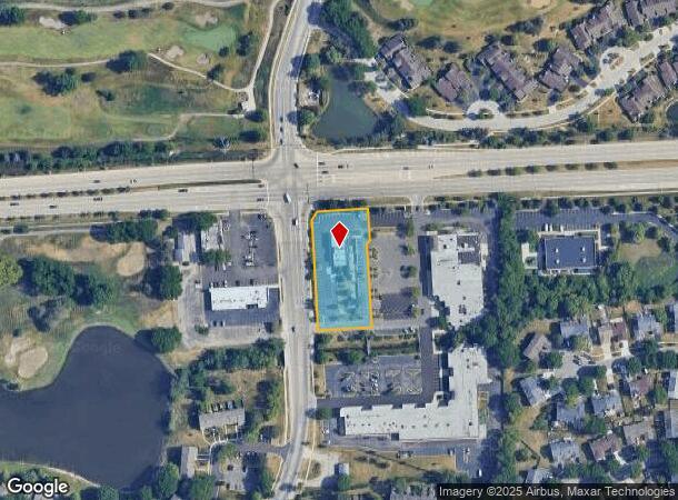
Property Record
1801 W Golf Rd, Schaumburg, IL 60194

NEARBY LISTINGS FOR SALE OR LEASE
Property Detail
1801 W Golf Rd
Commercialbuilding
Cook
X
Illinois
17031C0167J
0.96 AC
2023
Schaumburg Area
2024
Chicago
804716
Chicago-Naperville-Elgin, IL-IN-WI
3,551 SF
07-17-117-002-0000
DEMOGRAPHICS near 1801 W Golf Rd
1 Mile
3 Mile
5 Mile
2024 Total Population
19,997
98,680
234,004
2029 Population
19,455
95,558
226,777
Pop Growth 2024-2029
(2.71%)
(3.16%)
(3.09%)
Average Age
40
40
40
2024 Total Households
7,267
35,499
84,154
HH Growth 2024-2029
(2.89%)
(3.46%)
(3.38%)
Median Household Inc
$76,337
$85,267
$92,308
Avg Household Size
2.60
2.70
2.70
2024 Avg HH Vehicles
2.00
2.00
2.00
Median Home Value
$274,020
$263,893
$290,408
Median Year Built
1978
1975
1977
Nearby Places
Map Layers
Map Styles
 Street
 Aerial
- Restaurants
- Banks
- Shops
- Fitness
- Groceries
PUBLIC TRANSPORTATION
COMMUTER RAIL
Hanover Park Station (Milwaukee District West Line - Northeast Illinois Regional Commuter Railroad (Metra))
DRIVE
WALK
Distance
Hanover Park Station (Milwaukee District West Line - Northeast Illinois Regional Commuter Railroad (Metra))
11 min
5.4 mi
Schaumburg Station (Milwaukee District West Line - Northeast Illinois Regional Commuter Railroad (Metra))
DRIVE
WALK
Distance
Schaumburg Station (Milwaukee District West Line - Northeast Illinois Regional Commuter Railroad (Metra))
13 min
6.1 mi
AIRPORT
Chicago O'Hare International
DRIVE
WALK
Distance
Chicago O'Hare International
44 min
19.7 mi
Chicago Midway International
DRIVE
WALK
Distance
Chicago Midway International
58 min
33.5 mi
Nearby Properties
Address
Land Use
TOTAL SIZE
Lot Size
Zoning
Address
Land Use
TOTAL SIZE
Lot Size
Zoning
1,367,997 SF
Address
Land Use
TOTAL SIZE
Lot Size
Zoning
Address
Land Use
TOTAL SIZE
Lot Size
Zoning
Address
Land Use
TOTAL SIZE
Lot Size
Zoning
934,038 SF
45.88 AC
Address
Land Use
TOTAL SIZE
Lot Size
Zoning
245,525 SF
14.69 AC
Address
Land Use
TOTAL SIZE
Lot Size
Zoning
388,080 SF
12.64 AC
Address
Land Use
TOTAL SIZE
Lot Size
Zoning
527,661 SF
27.39 AC
Address
Land Use
TOTAL SIZE
Lot Size
Zoning
130,923 SF
13.15 AC
Address
Land Use
TOTAL SIZE
Lot Size
Zoning
239,700 SF
Address
Land Use
TOTAL SIZE
Lot Size
Zoning
382,200 SF
45.71 AC
Address
Land Use
TOTAL SIZE
Lot Size
Zoning
302,135 SF
19.28 AC
Address
Land Use
TOTAL SIZE
Lot Size
Zoning
161,514 SF
11.17 AC
Address
Land Use
TOTAL SIZE
Lot Size
Zoning
240,352 SF
9.65 AC
Address
Land Use
TOTAL SIZE
Lot Size
Zoning
133,712 SF
16.65 AC
Address
Land Use
TOTAL SIZE
Lot Size
Zoning
Address
Land Use
TOTAL SIZE
Lot Size
Zoning
179,497 SF
12.33 AC
Address
Land Use
TOTAL SIZE
Lot Size
Zoning
93,333 SF
22.45 AC
Address
Land Use
TOTAL SIZE
Lot Size
Zoning
61,623 SF
3.73 AC
Address
Land Use
TOTAL SIZE
Lot Size
Zoning
Address
Land Use
TOTAL SIZE
Lot Size
Zoning
Address
Land Use
TOTAL SIZE
Lot Size
Zoning
392,258 SF
12.51 AC
Address
Land Use
TOTAL SIZE
Lot Size
Zoning
272,944 SF
4.74 AC
Address
Land Use
TOTAL SIZE
Lot Size
Zoning
224,794 SF
Address
Land Use
TOTAL SIZE
Lot Size
Zoning
161,280 SF
5.50 AC
Address
Land Use
TOTAL SIZE
Lot Size
Zoning
Address
Land Use
TOTAL SIZE
Lot Size
Zoning
175,200 SF
89.08 AC
Address
Land Use
TOTAL SIZE
Lot Size
Zoning
29,250 SF
2.57 AC
Address
Land Use
TOTAL SIZE
Lot Size
Zoning
122,368 SF
10.19 AC
Address
Land Use
TOTAL SIZE
Lot Size
Zoning
Address
Land Use
TOTAL SIZE
Lot Size
Zoning
63,961 SF
8.89 AC
The World's #1 Commercial Real Estate Marketplace
Connect with us
© 2025 CoStar Group
The information above has been obtained from sources believed reliable. While we do not doubt its accuracy we have not verified it and make no guarantee, warranty or representation about it. It is your responsibility to independently confirm its accuracy and completeness. Any projections, opinions, assumptions, or estimates used are for example only and do not represent the current or future performance of the property. The value of this transaction to you depends on tax and other factors which should be evaluated by your tax, financial, and legal advisors. You and your advisors should conduct a careful, independent investigation of the property to determine to your satisfaction the suitability of the property for your needs.