Property Record
1802 N Reading Rd, Stevens, PA 17578
NEARBY LISTINGS FOR SALE OR LEASE
-
-
View all Stevens listings for lease on LoopNet.com
Property Detail
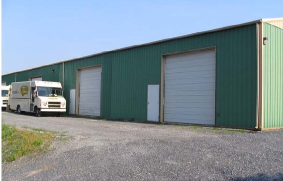
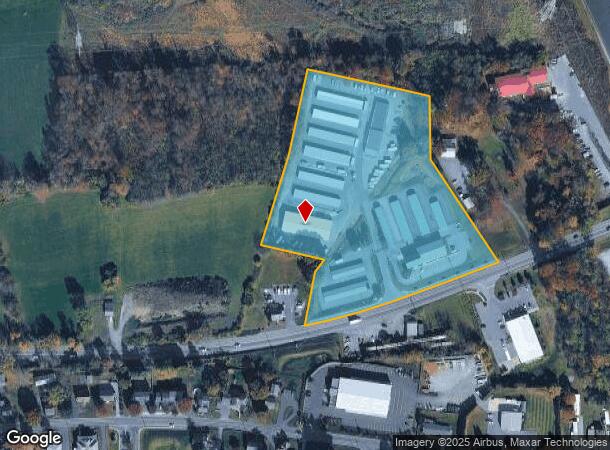
1802 N Reading Rd
Shipyard
Lancaster
X
Pennsylvania
42071C0201F
7.75 AC
2024
Lancaster County
2025
Philadelphia
012502
Lancaster, PA
64,302 SF
080-84978-0-0000
DEMOGRAPHICS near 1802 N Reading Rd
1 Mile
3 Mile
5 Mile
2024 Total Population
2,563
16,851
46,962
2029 Population
2,517
16,813
47,071
Pop Growth 2024-2029
(1.79%)
(0.23%)
+ 0.23%
Average Age
42
40
40
2024 Total Households
1,010
6,203
17,242
HH Growth 2024-2029
(1.98%)
(0.29%)
+ 0.26%
Median Household Inc
$66,542
$85,114
$76,454
Avg Household Size
2.50
2.70
2.70
2024 Avg HH Vehicles
2.00
2.00
2.00
Median Home Value
$194,888
$236,327
$243,825
Median Year Built
1973
1979
1976
Nearby Places
Map Layers
Map Styles
 Street
 Aerial
- Restaurants
- Banks
- Shops
- Fitness
- Groceries
PUBLIC TRANSPORTATION
AIRPORT
Harrisburg International
DRIVE
WALK
Distance
Harrisburg International
56 min
45.9 mi
Freight Ports
Port Newark Container Terminal
DRIVE
WALK
Distance
Port Newark Container Terminal
98 min
57.0 mi
SALE & LEASE HISTORY
LISTING DATE
SALE/LEASE

Aug 05, 2024
For Lease
Nearby Properties
Address
Land Use
TOTAL SIZE
Lot Size
Zoning
Address
Land Use
TOTAL SIZE
Lot Size
Zoning
1,588,498 SF
150.55 AC
I-1
Address
Land Use
TOTAL SIZE
Lot Size
Zoning
273,832 SF
57.10 AC
INS
Address
Land Use
TOTAL SIZE
Lot Size
Zoning
287,197 SF
40.40 AC
INS
Address
Land Use
TOTAL SIZE
Lot Size
Zoning
13,192 SF
9.20 AC
C-1
Address
Land Use
TOTAL SIZE
Lot Size
Zoning
419,345 SF
48.05 AC
I-1
Address
Land Use
TOTAL SIZE
Lot Size
Zoning
561,324 SF
114.10 AC
I-1
Address
Land Use
TOTAL SIZE
Lot Size
Zoning
97,573 SF
33.72 AC
I1
Address
Land Use
TOTAL SIZE
Lot Size
Zoning
513,058 SF
36.40 AC
I-1
Address
Land Use
TOTAL SIZE
Lot Size
Zoning
170,735 SF
18.76 AC
Address
Land Use
TOTAL SIZE
Lot Size
Zoning
95,121 SF
23.68 AC
Address
Land Use
TOTAL SIZE
Lot Size
Zoning
117,000 SF
12.98 AC
I-1
Address
Land Use
TOTAL SIZE
Lot Size
Zoning
213,220 SF
22.80 AC
I-1
Address
Land Use
TOTAL SIZE
Lot Size
Zoning
107,888 SF
28.30 AC
I-2
Address
Land Use
TOTAL SIZE
Lot Size
Zoning
75,227 SF
10.60 AC
R-60
Address
Land Use
TOTAL SIZE
Lot Size
Zoning
91,630 SF
16.56 AC
I-1
Address
Land Use
TOTAL SIZE
Lot Size
Zoning
87,504 SF
59.27 AC
Address
Land Use
TOTAL SIZE
Lot Size
Zoning
73,290 SF
12.83 AC
Address
Land Use
TOTAL SIZE
Lot Size
Zoning
41,012 SF
2.49 AC
C-1
Address
Land Use
TOTAL SIZE
Lot Size
Zoning
270,732 SF
9.50 AC
I-1
Address
Land Use
TOTAL SIZE
Lot Size
Zoning
98,846 SF
32.95 AC
Address
Land Use
TOTAL SIZE
Lot Size
Zoning
96,337 SF
34.60 AC
I
Address
Land Use
TOTAL SIZE
Lot Size
Zoning
35,237 SF
13.70 AC
R-1
Address
Land Use
TOTAL SIZE
Lot Size
Zoning
50,389 SF
10.07 AC
C-1
Address
Land Use
TOTAL SIZE
Lot Size
Zoning
40,793 SF
4 AC
C-1
Address
Land Use
TOTAL SIZE
Lot Size
Zoning
199,506 SF
20.60 AC
I
Address
Land Use
TOTAL SIZE
Lot Size
Zoning
142,935 SF
6.51 AC
I
Address
Land Use
TOTAL SIZE
Lot Size
Zoning
48,150 SF
19.73 AC
I
Address
Land Use
TOTAL SIZE
Lot Size
Zoning
128,000 SF
8.28 AC
I-1
Address
Land Use
TOTAL SIZE
Lot Size
Zoning
91,642 SF
11.30 AC
I-1
Address
Land Use
TOTAL SIZE
Lot Size
Zoning
94,918 SF
10 AC
I-1
The World's #1 Commercial Real Estate Marketplace
Connect with us
© 2026 CoStar Group
The information above has been obtained from sources believed reliable. While we do not doubt its accuracy we have not verified it and make no guarantee, warranty or representation about it. It is your responsibility to independently confirm its accuracy and completeness. Any projections, opinions, assumptions, or estimates used are for example only and do not represent the current or future performance of the property. The value of this transaction to you depends on tax and other factors which should be evaluated by your tax, financial, and legal advisors. You and your advisors should conduct a careful, independent investigation of the property to determine to your satisfaction the suitability of the property for your needs.