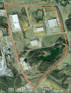
Property Record
1802 Rome Hwy, Rockmart, GA 30153
Property Detail
1802 Rome Hwy
Cedartown, GA
LLS 576 577 18TH DISTRICT THIRD SECTION
059-010J
Polk
Industrialacreage
Georgia
B and X Area of moderate flood hazard, usually the area between the limits of the 100-year and 500-year floods.
41.09 AC
2025
Georgia Northwest
2025
Other Market Areas
010600
NEARBY LISTINGS FOR SALE OR LEASE
DEMOGRAPHICS near 1802 Rome Hwy
1 mile
3 mile
5 mile
2025 Total Population
475
10,619
15,642
2030 Population
480
10,946
16,188
Pop Growth 2025-2030
+ 1.05%
+ 3.08%
+ 3.49%
Average Age
39
40
40
2025 Total Households
186
4,105
5,958
HH Growth 2025-2030
+ 0.54%
+ 3.05%
+ 3.42%
Median Household Inc
$51,896
$54,547
$54,631
Avg Household Size
2.60
2.60
2.60
2025 Avg HH Vehicles
2.00
2.00
2.00
Median Home Value
$214,286
$185,789
$196,723
Median Year Built
1985
1983
1986
Nearby Places
Map Layers
Map Styles
 Street
 Aerial
Layers
 Traffic
 Biking
Places
Listings with unknown addresses are not visible on the map
- Restaurants
- Banks
- Shops
- Fitness
- Groceries
Nearby Properties
Address
Land Use
TOTAL SIZE
Lot Size
Zoning
Address
Land Use
TOTAL SIZE
Lot Size
Zoning
417,231 SF
43.43 AC
Address
Land Use
TOTAL SIZE
Lot Size
Zoning
27,750 SF
60.84 AC
Address
Land Use
TOTAL SIZE
Lot Size
Zoning
306,003 SF
19.69 AC
Address
Land Use
TOTAL SIZE
Lot Size
Zoning
9,153 SF
10.17 AC
Address
Land Use
TOTAL SIZE
Lot Size
Zoning
30,012 SF
91.47 AC
Address
Land Use
TOTAL SIZE
Lot Size
Zoning
22,500 SF
26.86 AC
Address
Land Use
TOTAL SIZE
Lot Size
Zoning
158,416 SF
21.64 AC
Address
Land Use
TOTAL SIZE
Lot Size
Zoning
147,168 SF
9.29 AC
Address
Land Use
TOTAL SIZE
Lot Size
Zoning
217,500 SF
28.19 AC
Address
Land Use
TOTAL SIZE
Lot Size
Zoning
99,378 SF
11.99 AC
Address
Land Use
TOTAL SIZE
Lot Size
Zoning
17,002 SF
7.72 AC
Address
Land Use
TOTAL SIZE
Lot Size
Zoning
Address
Land Use
TOTAL SIZE
Lot Size
Zoning
14,116 SF
8.12 AC
Address
Land Use
TOTAL SIZE
Lot Size
Zoning
55,115 SF
18 AC
Address
Land Use
TOTAL SIZE
Lot Size
Zoning
2,304 SF
85.86 AC
Address
Land Use
TOTAL SIZE
Lot Size
Zoning
1,068 SF
7.41 AC
Address
Land Use
TOTAL SIZE
Lot Size
Zoning
44,653 SF
8.18 AC
Address
Land Use
TOTAL SIZE
Lot Size
Zoning
15.88 AC
Address
Land Use
TOTAL SIZE
Lot Size
Zoning
10,425 SF
16.50 AC
Address
Land Use
TOTAL SIZE
Lot Size
Zoning
2,400 SF
321.10 AC
I-2
Address
Land Use
TOTAL SIZE
Lot Size
Zoning
14,032 SF
5.16 AC
Address
Land Use
TOTAL SIZE
Lot Size
Zoning
19,544 SF
12.56 AC
Address
Land Use
TOTAL SIZE
Lot Size
Zoning
22,300 SF
4.33 AC
Address
Land Use
TOTAL SIZE
Lot Size
Zoning
133,395 SF
9.53 AC
Address
Land Use
TOTAL SIZE
Lot Size
Zoning
1,200 SF
3.43 AC
Address
Land Use
TOTAL SIZE
Lot Size
Zoning
18,116 SF
1 AC
Address
Land Use
TOTAL SIZE
Lot Size
Zoning
13,476 SF
63 AC
Address
Land Use
TOTAL SIZE
Lot Size
Zoning
4,978 SF
1.70 AC
Address
Land Use
TOTAL SIZE
Lot Size
Zoning
40,378 SF
1.34 AC
Address
Land Use
TOTAL SIZE
Lot Size
Zoning
6,043 SF
1.67 AC
The World's #1 Commercial Real Estate Marketplace
Connect with us
© 2026 CoStar Group
The information above has been obtained from sources believed reliable. While we do not doubt its accuracy we have not verified it and make no guarantee, warranty or representation about it. It is your responsibility to independently confirm its accuracy and completeness. Any projections, opinions, assumptions, or estimates used are for example only and do not represent the current or future performance of the property. The value of this transaction to you depends on tax and other factors which should be evaluated by your tax, financial, and legal advisors. You and your advisors should conduct a careful, independent investigation of the property to determine to your satisfaction the suitability of the property for your needs.