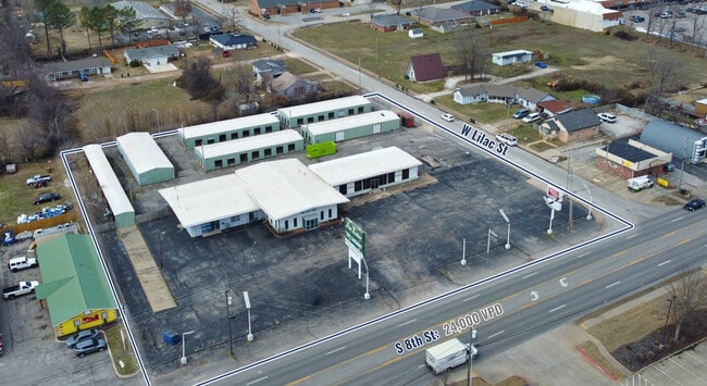
Property Record
1802 S 8Th St, Rogers, AR 72756


NEARBY LISTINGS FOR SALE OR LEASE
Property Detail
1802 S 8Th St
Fayetteville-Springdale-Rogers, AR
Pg Smiths Subdivision
02-06906-000
TRACT 17 IN P.G. SMITHS SUBDIVISION, ROGERS, BENTON COUNTY ARKANSAS, OF THE N 1/2 OF THE SW 1/4 AND N 1/2 OF THE SE 1/4 OF THE SW 1/4, SECTION 13, TOWNSHIP 19 NORTH, RANGE 30 WEST, EXCEPT 325 FEET SQUARELY OFF THE WEST SIDE THEREOF.
Officebuilding
Benton
X
Arkansas
05007C0260K
tct17
2025
2.23 AC
2025
East Rogers
020402
Fayetteville/Springdale/Rogers
20,392 SF
DEMOGRAPHICS near 1802 S 8Th St
1 Mile
3 Mile
5 Mile
2024 Total Population
9,150
53,219
99,560
2029 Population
10,615
62,342
116,834
Pop Growth 2024-2029
+ 16.01%
+ 17.14%
+ 17.35%
Average Age
37
36
37
2024 Total Households
3,086
18,903
36,468
HH Growth 2024-2029
+ 16.04%
+ 17.35%
+ 17.52%
Median Household Inc
$59,486
$62,635
$72,837
Avg Household Size
2.80
2.70
2.60
2024 Avg HH Vehicles
2.00
2.00
2.00
Median Home Value
$158,293
$181,896
$231,592
Median Year Built
1985
1991
1995
Nearby Places
Map Layers
Map Styles
 Street
 Aerial
- Restaurants
- Banks
- Shops
- Fitness
- Groceries
PUBLIC TRANSPORTATION
AIRPORT
Northwest Arkansas Ntl
DRIVE
WALK
Distance
Northwest Arkansas Ntl
31 min
16.1 mi
Freight Ports
Tulsa Port of Inola
DRIVE
WALK
Distance
Tulsa Port of Inola
113 min
95.2 mi
SALE & LEASE HISTORY
LISTING DATE
SALE/LEASE

Mar 13, 2025
For Sale
Nearby Properties
Address
Land Use
TOTAL SIZE
Lot Size
Zoning
Address
Land Use
TOTAL SIZE
Lot Size
Zoning
52,778 SF
1.04 AC
Address
Land Use
TOTAL SIZE
Lot Size
Zoning
441,673 SF
55.19 AC
Address
Land Use
TOTAL SIZE
Lot Size
Zoning
117,522 SF
0.12 AC
Address
Land Use
TOTAL SIZE
Lot Size
Zoning
405,394 SF
10.97 AC
Address
Land Use
TOTAL SIZE
Lot Size
Zoning
412,893 SF
11.51 AC
Address
Land Use
TOTAL SIZE
Lot Size
Zoning
269,397 SF
27.07 AC
Address
Land Use
TOTAL SIZE
Lot Size
Zoning
305,450 SF
12.16 AC
Address
Land Use
TOTAL SIZE
Lot Size
Zoning
542,873 SF
16.52 AC
Address
Land Use
TOTAL SIZE
Lot Size
Zoning
365,674 SF
18.05 AC
Address
Land Use
TOTAL SIZE
Lot Size
Zoning
84,890 SF
5.89 AC
Address
Land Use
TOTAL SIZE
Lot Size
Zoning
166,973 SF
7.58 AC
Address
Land Use
TOTAL SIZE
Lot Size
Zoning
30,456 SF
7.78 AC
Address
Land Use
TOTAL SIZE
Lot Size
Zoning
573,476 SF
57.80 AC
Address
Land Use
TOTAL SIZE
Lot Size
Zoning
401,143 SF
31.17 AC
Address
Land Use
TOTAL SIZE
Lot Size
Zoning
210,971 SF
8.46 AC
Address
Land Use
TOTAL SIZE
Lot Size
Zoning
209,369 SF
21.60 AC
Address
Land Use
TOTAL SIZE
Lot Size
Zoning
214,791 SF
9.13 AC
Address
Land Use
TOTAL SIZE
Lot Size
Zoning
156,100 SF
7.89 AC
Address
Land Use
TOTAL SIZE
Lot Size
Zoning
20,878 SF
24.78 AC
Address
Land Use
TOTAL SIZE
Lot Size
Zoning
152,759 SF
12.01 AC
Address
Land Use
TOTAL SIZE
Lot Size
Zoning
203,254 SF
12.93 AC
Address
Land Use
TOTAL SIZE
Lot Size
Zoning
67,152 SF
6.28 AC
Address
Land Use
TOTAL SIZE
Lot Size
Zoning
39,204 SF
4.03 AC
Address
Land Use
TOTAL SIZE
Lot Size
Zoning
114,250 SF
7.54 AC
Address
Land Use
TOTAL SIZE
Lot Size
Zoning
117,522 SF
13.66 AC
Address
Land Use
TOTAL SIZE
Lot Size
Zoning
231,576 SF
15.18 AC
Address
Land Use
TOTAL SIZE
Lot Size
Zoning
102,477 SF
7.15 AC
Address
Land Use
TOTAL SIZE
Lot Size
Zoning
57,715 SF
7.60 AC
Address
Land Use
TOTAL SIZE
Lot Size
Zoning
75,063 SF
2.50 AC
Address
Land Use
TOTAL SIZE
Lot Size
Zoning
87,465 SF
5 AC
The World's #1 Commercial Real Estate Marketplace
Connect with us
© 2026 CoStar Group
The information above has been obtained from sources believed reliable. While we do not doubt its accuracy we have not verified it and make no guarantee, warranty or representation about it. It is your responsibility to independently confirm its accuracy and completeness. Any projections, opinions, assumptions, or estimates used are for example only and do not represent the current or future performance of the property. The value of this transaction to you depends on tax and other factors which should be evaluated by your tax, financial, and legal advisors. You and your advisors should conduct a careful, independent investigation of the property to determine to your satisfaction the suitability of the property for your needs.