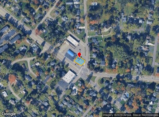
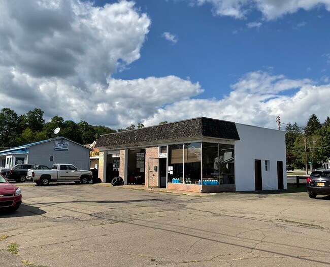
Property Record
1802 W Water St, Elmira, NY 14905

NEARBY LISTINGS FOR SALE OR LEASE
Property Detail
1802 W Water St
Elmira, NY
482 PT LOT 20 BERTHOD PLOT
073089-098-006-0002-010-000-0000
Chemung
Autorepair
New York
2025
10.000
2024
0.17 AC
010900
Ithaca/Elmira
1,350 SF
Other Market Areas
DEMOGRAPHICS near 1802 W Water St
1 Mile
3 Mile
5 Mile
2024 Total Population
3,402
28,848
47,741
2029 Population
3,336
28,496
46,944
Pop Growth 2024-2029
(1.94%)
(1.22%)
(1.67%)
Average Age
45
41
41
2024 Total Households
1,473
12,066
20,117
HH Growth 2024-2029
(2.10%)
(1.32%)
(1.82%)
Median Household Inc
$109,329
$55,642
$53,272
Avg Household Size
2.20
2.20
2.20
2024 Avg HH Vehicles
2.00
2.00
2.00
Median Home Value
$191,023
$127,667
$119,717
Median Year Built
1948
1948
1948
Nearby Places
- Restaurants
- Banks
- Shops
- Fitness
- Groceries
PUBLIC TRANSPORTATION
AIRPORT
Elmira/Corning Regional
DRIVE
WALK
Distance
Elmira/Corning Regional
18 min
10.4 mi
Freight Ports
Albany, NY Port
DRIVE
WALK
Distance
Albany, NY Port
236 min
197.3 mi
SALE & LEASE HISTORY
LISTING DATE
SALE/LEASE

Sep 18, 2025
For Sale
Nearby Properties
Address
Land Use
TOTAL SIZE
Lot Size
Zoning
Address
Land Use
TOTAL SIZE
Lot Size
Zoning
59 AC
UNZONED
Address
Land Use
TOTAL SIZE
Lot Size
Zoning
308,479 SF
28.20 AC
HA
Address
Land Use
TOTAL SIZE
Lot Size
Zoning
290,934 SF
13.50 AC
HED
Address
Land Use
TOTAL SIZE
Lot Size
Zoning
25,388 SF
58.90 AC
RAA
Address
Land Use
TOTAL SIZE
Lot Size
Zoning
52,628 SF
2.40 AC
HED
Address
Land Use
TOTAL SIZE
Lot Size
Zoning
208,197 SF
39.40 AC
R-2
Address
Land Use
TOTAL SIZE
Lot Size
Zoning
Address
Land Use
TOTAL SIZE
Lot Size
Zoning
61,157 SF
1 AC
CBD
Address
Land Use
TOTAL SIZE
Lot Size
Zoning
136,977 SF
2.55 AC
HED
Address
Land Use
TOTAL SIZE
Lot Size
Zoning
194,626 SF
10.20 AC
RAA
Address
Land Use
TOTAL SIZE
Lot Size
Zoning
5,562 SF
22.64 AC
RD
Address
Land Use
TOTAL SIZE
Lot Size
Zoning
157,418 SF
0.72 AC
CBD
Address
Land Use
TOTAL SIZE
Lot Size
Zoning
159,458 SF
3.15 AC
UMU
Address
Land Use
TOTAL SIZE
Lot Size
Zoning
77,451 SF
4.70 AC
AA
Address
Land Use
TOTAL SIZE
Lot Size
Zoning
113,645 SF
3.80 AC
CBD
Address
Land Use
TOTAL SIZE
Lot Size
Zoning
72,994 SF
0.99 AC
CBD
Address
Land Use
TOTAL SIZE
Lot Size
Zoning
136,504 SF
5.50 AC
RB
Address
Land Use
TOTAL SIZE
Lot Size
Zoning
45,990 SF
2.51 AC
HED
Address
Land Use
TOTAL SIZE
Lot Size
Zoning
63,168 SF
4.25 AC
AA
Address
Land Use
TOTAL SIZE
Lot Size
Zoning
51,624 SF
4.01 AC
UMU
Address
Land Use
TOTAL SIZE
Lot Size
Zoning
25,014 SF
1.20 AC
CT
Address
Land Use
TOTAL SIZE
Lot Size
Zoning
86,444 SF
5.94 AC
RB
Address
Land Use
TOTAL SIZE
Lot Size
Zoning
14,716 SF
1.53 AC
UMU
Address
Land Use
TOTAL SIZE
Lot Size
Zoning
112,600 SF
8.20 AC
HED
Address
Land Use
TOTAL SIZE
Lot Size
Zoning
75,777 SF
9.20 AC
CT
Address
Land Use
TOTAL SIZE
Lot Size
Zoning
45,198 SF
1.90 AC
CBD
Address
Land Use
TOTAL SIZE
Lot Size
Zoning
13,485 SF
3.67 AC
R-2
Address
Land Use
TOTAL SIZE
Lot Size
Zoning
Address
Land Use
TOTAL SIZE
Lot Size
Zoning
14,748 SF
1.74 AC
UMU
Address
Land Use
TOTAL SIZE
Lot Size
Zoning
25,339 SF
110 AC
AAA
The World's #1 Commercial Real Estate Marketplace
Connect with us
© 2025 CoStar Group
The information above has been obtained from sources believed reliable. While we do not doubt its accuracy we have not verified it and make no guarantee, warranty or representation about it. It is your responsibility to independently confirm its accuracy and completeness. Any projections, opinions, assumptions, or estimates used are for example only and do not represent the current or future performance of the property. The value of this transaction to you depends on tax and other factors which should be evaluated by your tax, financial, and legal advisors. You and your advisors should conduct a careful, independent investigation of the property to determine to your satisfaction the suitability of the property for your needs.