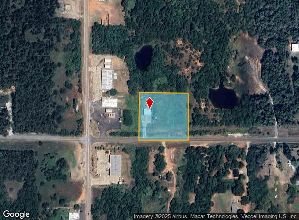
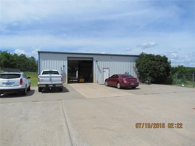
Property Record
18021 Se 149Th St, Newalla, OK 74857

NEARBY LISTINGS FOR SALE OR LEASE
-
-
View all Newalla listings for sale on LoopNet.com
Property Detail
18021 Se 149Th St
R0158755
21-10-1E 2.33 ACS PRT SW/4 BEG 349 S & 333.71 E NW/C SW/4 SW/4 SW/4 E323.06 S311.33 W328.72 N311.34 POB AKA PARCEL B
Lightindustrial
Cleveland
X
Oklahoma
40125C0175H
2.33 AC
2024
Outlying Cleveland County
2024
Oklahoma City
202302
Oklahoma City, OK
2,000 SF
DEMOGRAPHICS near 18021 Se 149Th St
1 Mile
3 Mile
5 Mile
2024 Total Population
684
4,302
12,635
2029 Population
720
4,526
13,275
Pop Growth 2024-2029
+ 5.26%
+ 5.21%
+ 5.07%
Average Age
41
41
42
2024 Total Households
242
1,533
4,576
HH Growth 2024-2029
+ 5.79%
+ 5.41%
+ 5.24%
Median Household Inc
$75,255
$75,578
$81,788
Avg Household Size
2.80
2.70
2.70
2024 Avg HH Vehicles
3.00
3.00
3.00
Median Home Value
$155,681
$161,171
$178,435
Median Year Built
1997
1992
1995
Nearby Places
Map Layers
Map Styles
 Street
 Aerial
- Restaurants
- Banks
- Shops
- Fitness
- Groceries
PUBLIC TRANSPORTATION
AIRPORT
Will Rogers World
DRIVE
WALK
Distance
Will Rogers World
49 min
29.3 mi
Freight Ports
Tulsa Port Of Catoosa
DRIVE
WALK
Distance
Tulsa Port Of Catoosa
139 min
122.6 mi
SALE & LEASE HISTORY
LISTING DATE
SALE/LEASE

Sep 24, 2016
For Sale
May 05, 2018
For Sale
Nearby Properties
Address
Land Use
TOTAL SIZE
Lot Size
Zoning
Address
Land Use
TOTAL SIZE
Lot Size
Zoning
7,560 SF
4.69 AC
A1
Address
Land Use
TOTAL SIZE
Lot Size
Zoning
229.96 AC
Address
Land Use
TOTAL SIZE
Lot Size
Zoning
159.45 AC
Address
Land Use
TOTAL SIZE
Lot Size
Zoning
5.18 AC
A1
Address
Land Use
TOTAL SIZE
Lot Size
Zoning
171.54 AC
Address
Land Use
TOTAL SIZE
Lot Size
Zoning
170 AC
Address
Land Use
TOTAL SIZE
Lot Size
Zoning
80 AC
Address
Land Use
TOTAL SIZE
Lot Size
Zoning
160 AC
Address
Land Use
TOTAL SIZE
Lot Size
Zoning
76.68 AC
Address
Land Use
TOTAL SIZE
Lot Size
Zoning
3,600 SF
4.55 AC
Address
Land Use
TOTAL SIZE
Lot Size
Zoning
9,170 SF
2.70 AC
Address
Land Use
TOTAL SIZE
Lot Size
Zoning
4,788 SF
5.01 AC
Address
Land Use
TOTAL SIZE
Lot Size
Zoning
93.73 AC
Address
Land Use
TOTAL SIZE
Lot Size
Zoning
5.01 AC
Address
Land Use
TOTAL SIZE
Lot Size
Zoning
120 SF
5.74 AC
Address
Land Use
TOTAL SIZE
Lot Size
Zoning
10.01 AC
Address
Land Use
TOTAL SIZE
Lot Size
Zoning
5,000 SF
2.36 AC
Address
Land Use
TOTAL SIZE
Lot Size
Zoning
Address
Land Use
TOTAL SIZE
Lot Size
Zoning
1,064 SF
6.47 AC
Address
Land Use
TOTAL SIZE
Lot Size
Zoning
37.99 AC
Address
Land Use
TOTAL SIZE
Lot Size
Zoning
37.29 AC
Address
Land Use
TOTAL SIZE
Lot Size
Zoning
2,356 SF
49.32 AC
Address
Land Use
TOTAL SIZE
Lot Size
Zoning
1,092 SF
43 AC
Address
Land Use
TOTAL SIZE
Lot Size
Zoning
3,349 SF
5 AC
Address
Land Use
TOTAL SIZE
Lot Size
Zoning
Address
Land Use
TOTAL SIZE
Lot Size
Zoning
27.81 AC
Address
Land Use
TOTAL SIZE
Lot Size
Zoning
Address
Land Use
TOTAL SIZE
Lot Size
Zoning
3,000 SF
5 AC
Address
Land Use
TOTAL SIZE
Lot Size
Zoning
1.12 AC
The World's #1 Commercial Real Estate Marketplace
Connect with us
© 2025 CoStar Group
The information above has been obtained from sources believed reliable. While we do not doubt its accuracy we have not verified it and make no guarantee, warranty or representation about it. It is your responsibility to independently confirm its accuracy and completeness. Any projections, opinions, assumptions, or estimates used are for example only and do not represent the current or future performance of the property. The value of this transaction to you depends on tax and other factors which should be evaluated by your tax, financial, and legal advisors. You and your advisors should conduct a careful, independent investigation of the property to determine to your satisfaction the suitability of the property for your needs.