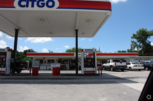
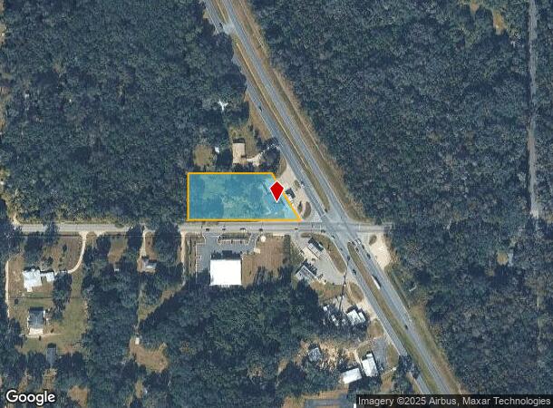
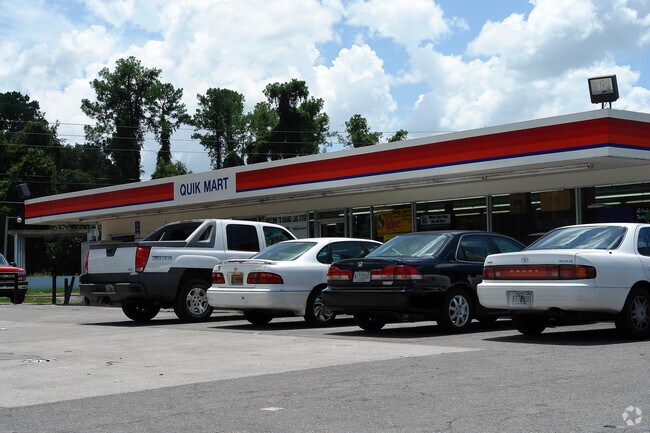
Property Record
18024 N Us Highway 441, Reddick, FL 32686
NEARBY LISTINGS FOR SALE OR LEASE
-
-
View all Reddick listings for sale on LoopNet.com
Property Detail
18024 N Us Highway 441
03112-000-00
SEC 28 TWP 12 RGE 21 COM SW COR OF SE 1/4 N 00-39-11 E 31.62 FT TO N ROW LN HWY C-318 POB N 00-39-11 E 187.84 FT S 89-52-23 E 334.12 FT TO WLY ROW LN HWY 441 S 29-57-21 E ALONG ROW LN 215.74 FT THAT IS WHEN MEASURED AT RIGHT ANGLE 31.62 FT FROM S BND
Storemultistory
Marion
X
Florida
12083C0140D
1.68 AC
2025
Outlying Marion County
2025
Ocala
000203
Ocala, FL
6,102 SF
DEMOGRAPHICS near 18024 N Us Highway 441
1 Mile
3 Mile
5 Mile
2024 Total Population
534
2,174
5,763
2029 Population
570
2,393
6,423
Pop Growth 2024-2029
+ 6.74%
+ 10.07%
+ 11.45%
Average Age
47
46
45
2024 Total Households
237
927
2,367
HH Growth 2024-2029
+ 6.33%
+ 9.71%
+ 11.41%
Median Household Inc
$46,166
$50,169
$53,852
Avg Household Size
2.30
2.30
2.30
2024 Avg HH Vehicles
2.00
2.00
2.00
Median Home Value
$231,632
$247,644
$258,675
Median Year Built
1981
1983
1984
Nearby Places
Map Layers
Map Styles
 Street
 Aerial
- Restaurants
- Banks
- Shops
- Fitness
- Groceries
PUBLIC TRANSPORTATION
AIRPORT
Gainesville Regional
DRIVE
WALK
Distance
Gainesville Regional
40 min
25.0 mi
Freight Ports
Jacksonville Port
DRIVE
WALK
Distance
Jacksonville Port
123 min
94.7 mi
Nearby Properties
Address
Land Use
TOTAL SIZE
Lot Size
Zoning
Address
Land Use
TOTAL SIZE
Lot Size
Zoning
11,331 SF
74.32 AC
PRV
Address
Land Use
TOTAL SIZE
Lot Size
Zoning
32,861 SF
115.49 AC
PRV
Address
Land Use
TOTAL SIZE
Lot Size
Zoning
95,851 SF
34.68 AC
I
Address
Land Use
TOTAL SIZE
Lot Size
Zoning
6,144 SF
140.91 AC
PUD
Address
Land Use
TOTAL SIZE
Lot Size
Zoning
38,715 SF
50 AC
B3
Address
Land Use
TOTAL SIZE
Lot Size
Zoning
2,616 SF
41.47 AC
PUD
Address
Land Use
TOTAL SIZE
Lot Size
Zoning
11,063 SF
417.23 AC
A1
Address
Land Use
TOTAL SIZE
Lot Size
Zoning
73,528 SF
171 AC
A1
Address
Land Use
TOTAL SIZE
Lot Size
Zoning
62,288 SF
49.98 AC
B4
Address
Land Use
TOTAL SIZE
Lot Size
Zoning
22,922 SF
20 AC
R1
Address
Land Use
TOTAL SIZE
Lot Size
Zoning
15,397 SF
7.24 AC
B2
Address
Land Use
TOTAL SIZE
Lot Size
Zoning
11,333 SF
243.73 AC
A1
Address
Land Use
TOTAL SIZE
Lot Size
Zoning
266 AC
A1
Address
Land Use
TOTAL SIZE
Lot Size
Zoning
10,580 SF
1.86 AC
B4
Address
Land Use
TOTAL SIZE
Lot Size
Zoning
5,792 SF
310 AC
A1
Address
Land Use
TOTAL SIZE
Lot Size
Zoning
6,456 SF
80.04 AC
A1
Address
Land Use
TOTAL SIZE
Lot Size
Zoning
9,603 SF
6.30 AC
GU
Address
Land Use
TOTAL SIZE
Lot Size
Zoning
11,280 SF
9.01 AC
B2
Address
Land Use
TOTAL SIZE
Lot Size
Zoning
21,287 SF
10.01 AC
B2
Address
Land Use
TOTAL SIZE
Lot Size
Zoning
83.57 AC
A1
Address
Land Use
TOTAL SIZE
Lot Size
Zoning
9,301 SF
1.32 AC
B
Address
Land Use
TOTAL SIZE
Lot Size
Zoning
6,468 SF
159.54 AC
A1
Address
Land Use
TOTAL SIZE
Lot Size
Zoning
9,230 SF
1.24 AC
B4
Address
Land Use
TOTAL SIZE
Lot Size
Zoning
21,655 SF
33.01 AC
A1
Address
Land Use
TOTAL SIZE
Lot Size
Zoning
5 AC
B2
Address
Land Use
TOTAL SIZE
Lot Size
Zoning
2,805 SF
52.99 AC
B2
Address
Land Use
TOTAL SIZE
Lot Size
Zoning
5,058 SF
159.97 AC
A1
Address
Land Use
TOTAL SIZE
Lot Size
Zoning
4,338 SF
287.47 AC
A1
Address
Land Use
TOTAL SIZE
Lot Size
Zoning
5,318 SF
7.09 AC
A1
Address
Land Use
TOTAL SIZE
Lot Size
Zoning
1,108 SF
29.96 AC
B2
The World's #1 Commercial Real Estate Marketplace
Connect with us
© 2026 CoStar Group
The information above has been obtained from sources believed reliable. While we do not doubt its accuracy we have not verified it and make no guarantee, warranty or representation about it. It is your responsibility to independently confirm its accuracy and completeness. Any projections, opinions, assumptions, or estimates used are for example only and do not represent the current or future performance of the property. The value of this transaction to you depends on tax and other factors which should be evaluated by your tax, financial, and legal advisors. You and your advisors should conduct a careful, independent investigation of the property to determine to your satisfaction the suitability of the property for your needs.