Property Record
18030 Fm 529 Rd, Cypress, TX 77433
NEARBY LISTINGS FOR SALE OR LEASE
Property Detail
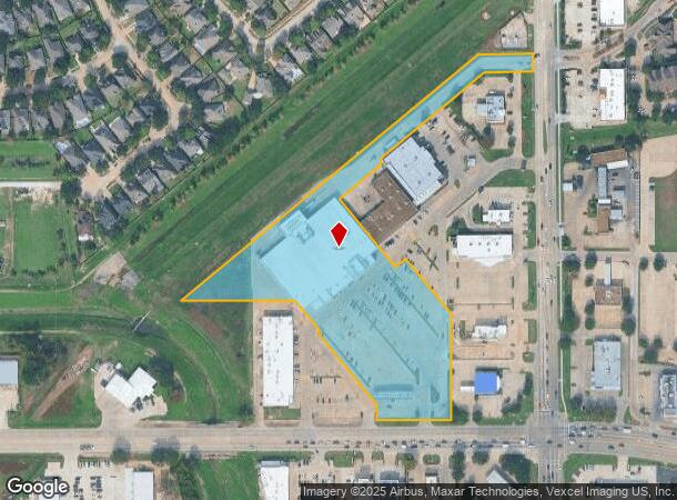
18030 Fm 529 Rd
1199430010002
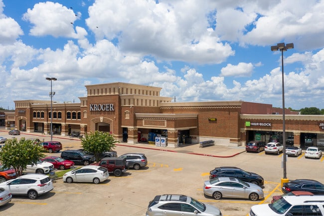
Langham Creek Shopping Center
Supermarket
RES B BLK 1 LANGHAM CREEK SHOPPING CENTER
X
Harris
48201C0420P
Texas
2024
7.02 AC
2025
Bridgeland
543008
Houston
66,891 SF
Houston-The Woodlands-Sugar Land, TX
DEMOGRAPHICS near 18030 Fm 529 Rd
1 Mile
3 Mile
5 Mile
2024 Total Population
19,272
162,006
324,889
2029 Population
19,453
164,116
330,651
Pop Growth 2024-2029
+ 0.94%
+ 1.30%
+ 1.77%
Average Age
35
35
35
2024 Total Households
5,802
50,071
101,263
HH Growth 2024-2029
+ 0.90%
+ 1.26%
+ 1.69%
Median Household Inc
$77,333
$87,820
$85,672
Avg Household Size
3.30
3.20
3.10
2024 Avg HH Vehicles
2.00
2.00
2.00
Median Home Value
$180,947
$221,192
$234,617
Median Year Built
1999
2002
2002
Nearby Places
Map Layers
Map Styles
 Street
 Aerial
- Restaurants
- Banks
- Shops
- Fitness
- Groceries
PUBLIC TRANSPORTATION
AIRPORT
George Bush Intcntl/Houston
DRIVE
WALK
Distance
George Bush Intcntl/Houston
39 min
26.6 mi
William P Hobby
DRIVE
WALK
Distance
William P Hobby
58 min
37.3 mi
Freight Ports
Port of Houston
DRIVE
WALK
Distance
Port of Houston
49 min
32.9 mi
SALE & LEASE HISTORY
LISTING DATE
SALE/LEASE

Sep 25, 2016
For Lease
Nearby Properties
Address
Land Use
TOTAL SIZE
Lot Size
Zoning
Address
Land Use
TOTAL SIZE
Lot Size
Zoning
386,642 SF
14.45 AC
Address
Land Use
TOTAL SIZE
Lot Size
Zoning
355,721 SF
13 AC
Address
Land Use
TOTAL SIZE
Lot Size
Zoning
379,588 SF
12.06 AC
Address
Land Use
TOTAL SIZE
Lot Size
Zoning
323,609 SF
12.71 AC
Address
Land Use
TOTAL SIZE
Lot Size
Zoning
331,263 SF
11.36 AC
Address
Land Use
TOTAL SIZE
Lot Size
Zoning
358,713 SF
19.91 AC
Address
Land Use
TOTAL SIZE
Lot Size
Zoning
320,084 SF
8.01 AC
Address
Land Use
TOTAL SIZE
Lot Size
Zoning
418,572 SF
24.76 AC
Address
Land Use
TOTAL SIZE
Lot Size
Zoning
388,223 SF
14.99 AC
Address
Land Use
TOTAL SIZE
Lot Size
Zoning
262,174 SF
11.64 AC
Address
Land Use
TOTAL SIZE
Lot Size
Zoning
290,927 SF
14.53 AC
Address
Land Use
TOTAL SIZE
Lot Size
Zoning
112,440 SF
8.02 AC
Address
Land Use
TOTAL SIZE
Lot Size
Zoning
292,466 SF
12.18 AC
Address
Land Use
TOTAL SIZE
Lot Size
Zoning
97,084 SF
2.09 AC
Address
Land Use
TOTAL SIZE
Lot Size
Zoning
191,673 SF
7.29 AC
Address
Land Use
TOTAL SIZE
Lot Size
Zoning
186,161 SF
8.65 AC
Address
Land Use
TOTAL SIZE
Lot Size
Zoning
147,900 SF
5.76 AC
Address
Land Use
TOTAL SIZE
Lot Size
Zoning
150,570 SF
18.16 AC
Address
Land Use
TOTAL SIZE
Lot Size
Zoning
116,997 SF
10.82 AC
Address
Land Use
TOTAL SIZE
Lot Size
Zoning
215,153 SF
16.34 AC
Address
Land Use
TOTAL SIZE
Lot Size
Zoning
116,160 SF
13.43 AC
Address
Land Use
TOTAL SIZE
Lot Size
Zoning
187,007 SF
9.76 AC
Address
Land Use
TOTAL SIZE
Lot Size
Zoning
125,907 SF
10.54 AC
Address
Land Use
TOTAL SIZE
Lot Size
Zoning
262,048 SF
7 AC
Address
Land Use
TOTAL SIZE
Lot Size
Zoning
131,152 SF
7.14 AC
Address
Land Use
TOTAL SIZE
Lot Size
Zoning
117,860 SF
12.44 AC
Address
Land Use
TOTAL SIZE
Lot Size
Zoning
166,638 SF
6.54 AC
Address
Land Use
TOTAL SIZE
Lot Size
Zoning
202,014 SF
5.49 AC
Address
Land Use
TOTAL SIZE
Lot Size
Zoning
252,100 SF
9.18 AC
Address
Land Use
TOTAL SIZE
Lot Size
Zoning
204,129 SF
The World's #1 Commercial Real Estate Marketplace
Connect with us
© 2025 CoStar Group
The information above has been obtained from sources believed reliable. While we do not doubt its accuracy we have not verified it and make no guarantee, warranty or representation about it. It is your responsibility to independently confirm its accuracy and completeness. Any projections, opinions, assumptions, or estimates used are for example only and do not represent the current or future performance of the property. The value of this transaction to you depends on tax and other factors which should be evaluated by your tax, financial, and legal advisors. You and your advisors should conduct a careful, independent investigation of the property to determine to your satisfaction the suitability of the property for your needs.