Property Record
18043 E State St, Vandalia, MI 49095
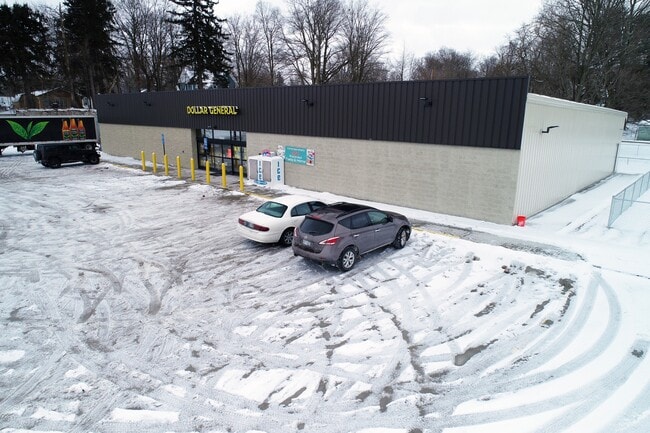

Property Detail
18043 E State St
South Bend-Mishawaka, IN-MI
431-546 V-13-14 THAT PART OF LOTS 14 & 15 DESC AS COM AT NW COR LOT 15, TH S 79 DEG 33' E 97.6 FT, S 77.3 FT, S 89 DEG 28'E 7
14-101-100-015-01
CASS
Commercialnec
Michigan
B and X Area of moderate flood hazard, usually the area between the limits of the 100-year and 500-year floods.
14,23
2024
1.88 AC
2025
Cass County
001600
South Bend/Mishawaka
9,100 SF
NEARBY LISTINGS FOR SALE OR LEASE
-
-
View all Vandalia listings for sale on LoopNet.com
DEMOGRAPHICS near 18043 E State St
1 mile
3 mile
5 mile
2025 Total Population
485
2,169
7,478
2030 Population
505
2,268
7,736
Pop Growth 2025-2030
+ 4.12%
+ 4.56%
+ 3.45%
Average Age
43
45
45
2025 Total Households
200
881
3,017
HH Growth 2025-2030
+ 4.00%
+ 4.54%
+ 3.38%
Median Household Inc
$67,749
$75,947
$75,983
Avg Household Size
2.40
2.40
2.40
2025 Avg HH Vehicles
2.00
2.00
2.00
Median Home Value
$293,999
$283,128
$258,108
Median Year Built
1961
1974
1973
Nearby Places
Map Layers
Map Styles
 Street
 Aerial
Transit
 Traffic
 Biking
Places
Listings with unknown addresses are not visible on the map
- Restaurants
- Banks
- Shops
- Fitness
- Groceries
PUBLIC TRANSPORTATION
AIRPORT
South Bend International
Drive
Walk
Distance
South Bend International
57 min
34.9 mi
Kalamazoo/Battle Creek International
Drive
Walk
Distance
Kalamazoo/Battle Creek International
58 min
41.3 mi
SALE & LEASE HISTORY
LISTING DATE
SALE/LEASE

Mar 10, 2020
For Sale
Jul 01, 2020
For Sale
Feb 09, 2021
For Sale
Nearby Properties
Address
Land Use
TOTAL SIZE
Lot Size
Zoning
Address
Land Use
TOTAL SIZE
Lot Size
Zoning
374,347 SF
64.39 AC
Address
Land Use
TOTAL SIZE
Lot Size
Zoning
157.75 AC
Address
Land Use
TOTAL SIZE
Lot Size
Zoning
Address
Land Use
TOTAL SIZE
Lot Size
Zoning
2,450 SF
Address
Land Use
TOTAL SIZE
Lot Size
Zoning
Address
Land Use
TOTAL SIZE
Lot Size
Zoning
0.55 AC
Address
Land Use
TOTAL SIZE
Lot Size
Zoning
41.03 AC
Address
Land Use
TOTAL SIZE
Lot Size
Zoning
Address
Land Use
TOTAL SIZE
Lot Size
Zoning
140.10 AC
Address
Land Use
TOTAL SIZE
Lot Size
Zoning
149.40 AC
Address
Land Use
TOTAL SIZE
Lot Size
Zoning
139.16 AC
Address
Land Use
TOTAL SIZE
Lot Size
Zoning
1,475 SF
79 AC
Address
Land Use
TOTAL SIZE
Lot Size
Zoning
111.49 AC
Address
Land Use
TOTAL SIZE
Lot Size
Zoning
155.18 AC
Address
Land Use
TOTAL SIZE
Lot Size
Zoning
85.72 AC
Address
Land Use
TOTAL SIZE
Lot Size
Zoning
138.96 AC
Address
Land Use
TOTAL SIZE
Lot Size
Zoning
15 AC
Address
Land Use
TOTAL SIZE
Lot Size
Zoning
85.18 AC
Address
Land Use
TOTAL SIZE
Lot Size
Zoning
Address
Land Use
TOTAL SIZE
Lot Size
Zoning
Address
Land Use
TOTAL SIZE
Lot Size
Zoning
0.47 AC
Address
Land Use
TOTAL SIZE
Lot Size
Zoning
95.83 AC
Address
Land Use
TOTAL SIZE
Lot Size
Zoning
95.92 AC
Address
Land Use
TOTAL SIZE
Lot Size
Zoning
Address
Land Use
TOTAL SIZE
Lot Size
Zoning
87.51 AC
Address
Land Use
TOTAL SIZE
Lot Size
Zoning
2,232 SF
0.11 AC
Address
Land Use
TOTAL SIZE
Lot Size
Zoning
10,000 SF
30 AC
Address
Land Use
TOTAL SIZE
Lot Size
Zoning
Address
Land Use
TOTAL SIZE
Lot Size
Zoning
980 SF
98.43 AC
The World's #1 Commercial Real Estate Marketplace
Connect with us
© 2026 CoStar Group
The information above has been obtained from sources believed reliable. While we do not doubt its accuracy we have not verified it and make no guarantee, warranty or representation about it. It is your responsibility to independently confirm its accuracy and completeness. Any projections, opinions, assumptions, or estimates used are for example only and do not represent the current or future performance of the property. The value of this transaction to you depends on tax and other factors which should be evaluated by your tax, financial, and legal advisors. You and your advisors should conduct a careful, independent investigation of the property to determine to your satisfaction the suitability of the property for your needs.