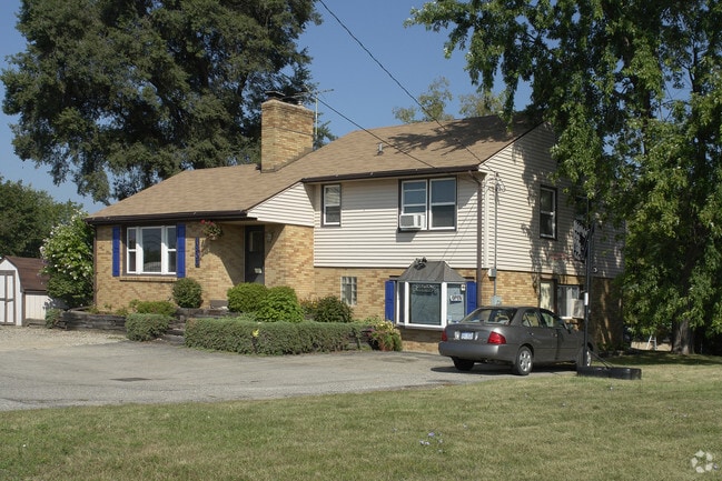
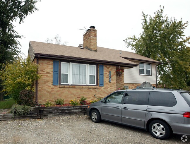
Property Record
1805 44Th St Se, Grand Rapids, MI 49508
NEARBY LISTINGS FOR SALE OR LEASE
Property Detail
1805 44Th St Se
Grand Rapids-Wyoming, MI
Kentwood Hills No 1
41-18-21-376-025
LOT 39* KENTWOOD HILLS NO 1
Officebuilding
Kent
X
Michigan
26081C0438D
39
2024
0.30 AC
2025
S Grand Rapids/Kentwood
004502
West Michigan
2,140 SF
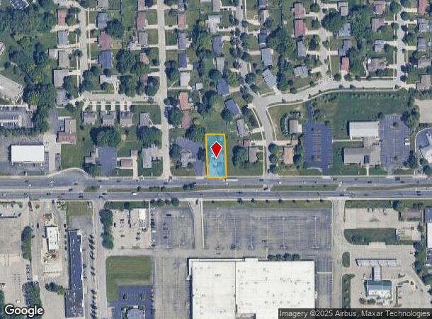
DEMOGRAPHICS near 1805 44Th St Se
1 Mile
3 Mile
5 Mile
2024 Total Population
15,434
89,302
225,687
2029 Population
15,501
90,040
227,242
Pop Growth 2024-2029
+ 0.43%
+ 0.83%
+ 0.69%
Average Age
38
38
37
2024 Total Households
6,001
34,801
83,819
HH Growth 2024-2029
+ 0.43%
+ 0.82%
+ 0.72%
Median Household Inc
$56,298
$62,331
$64,264
Avg Household Size
2.50
2.50
2.60
2024 Avg HH Vehicles
1.00
2.00
2.00
Median Home Value
$217,874
$211,971
$214,115
Median Year Built
1981
1977
1971
Nearby Places
Map Layers
Map Styles
 Street
 Aerial
- Restaurants
- Banks
- Shops
- Fitness
- Groceries
PUBLIC TRANSPORTATION
COMMUTER RAIL
DRIVE
WALK
Distance
13 min
8.5 mi
AIRPORT
Gerald R Ford International
DRIVE
WALK
Distance
Gerald R Ford International
14 min
6.4 mi
Nearby Properties
Address
Land Use
TOTAL SIZE
Lot Size
Zoning
Address
Land Use
TOTAL SIZE
Lot Size
Zoning
563,998 SF
31.75 AC
C3
Address
Land Use
TOTAL SIZE
Lot Size
Zoning
385,631 SF
45.27 AC
R-PUD-1
Address
Land Use
TOTAL SIZE
Lot Size
Zoning
446,986 SF
72.57 AC
R4
Address
Land Use
TOTAL SIZE
Lot Size
Zoning
341,808 SF
27.73 AC
HC-PUD
Address
Land Use
TOTAL SIZE
Lot Size
Zoning
48.43 AC
PUD-PL UNI
Address
Land Use
TOTAL SIZE
Lot Size
Zoning
649,177 SF
55.67 AC
SD-IT
Address
Land Use
TOTAL SIZE
Lot Size
Zoning
223,931 SF
18 AC
R-PUD-1
Address
Land Use
TOTAL SIZE
Lot Size
Zoning
941,968 SF
38.56 AC
SD-IT
Address
Land Use
TOTAL SIZE
Lot Size
Zoning
216,171 SF
32.06 AC
R4
Address
Land Use
TOTAL SIZE
Lot Size
Zoning
27.25 AC
SD-PRD
Address
Land Use
TOTAL SIZE
Lot Size
Zoning
1,426,319 SF
54.81 AC
SD-IT
Address
Land Use
TOTAL SIZE
Lot Size
Zoning
292,825 SF
15.01 AC
R-PUD-1
Address
Land Use
TOTAL SIZE
Lot Size
Zoning
267,336 SF
13.99 AC
R-PUD-1
Address
Land Use
TOTAL SIZE
Lot Size
Zoning
38.98 AC
PUD-PL UNI
Address
Land Use
TOTAL SIZE
Lot Size
Zoning
127,141 SF
17.04 AC
C2
Address
Land Use
TOTAL SIZE
Lot Size
Zoning
264,739 SF
26.56 AC
I2
Address
Land Use
TOTAL SIZE
Lot Size
Zoning
25.05 AC
R3-MED RES
Address
Land Use
TOTAL SIZE
Lot Size
Zoning
13.71 AC
MCN-LDR
Address
Land Use
TOTAL SIZE
Lot Size
Zoning
330,346 SF
49.71 AC
I1
Address
Land Use
TOTAL SIZE
Lot Size
Zoning
304,200 SF
R1
Address
Land Use
TOTAL SIZE
Lot Size
Zoning
146,732 SF
21.16 AC
R4
Address
Land Use
TOTAL SIZE
Lot Size
Zoning
153,571 SF
12.28 AC
SD-PRD
Address
Land Use
TOTAL SIZE
Lot Size
Zoning
258,128 SF
20.41 AC
R4
Address
Land Use
TOTAL SIZE
Lot Size
Zoning
536,296 SF
26.16 AC
SD-IT
Address
Land Use
TOTAL SIZE
Lot Size
Zoning
179,436 SF
24.94 AC
I2
Address
Land Use
TOTAL SIZE
Lot Size
Zoning
295,250 SF
Address
Land Use
TOTAL SIZE
Lot Size
Zoning
225,906 SF
14.40 AC
R4
Address
Land Use
TOTAL SIZE
Lot Size
Zoning
63,000 SF
15.28 AC
C3
Address
Land Use
TOTAL SIZE
Lot Size
Zoning
194,254 SF
13.55 AC
I1
Address
Land Use
TOTAL SIZE
Lot Size
Zoning
136,112 SF
17.63 AC
MON-C
The World's #1 Commercial Real Estate Marketplace
Connect with us
© 2025 CoStar Group
The information above has been obtained from sources believed reliable. While we do not doubt its accuracy we have not verified it and make no guarantee, warranty or representation about it. It is your responsibility to independently confirm its accuracy and completeness. Any projections, opinions, assumptions, or estimates used are for example only and do not represent the current or future performance of the property. The value of this transaction to you depends on tax and other factors which should be evaluated by your tax, financial, and legal advisors. You and your advisors should conduct a careful, independent investigation of the property to determine to your satisfaction the suitability of the property for your needs.