Property Record
1805 Aviation Dr, Georgetown, TX 78628
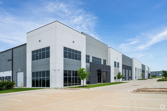
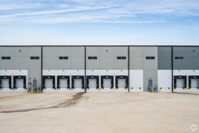
Property Detail
1805 Aviation Dr
Austin-Round Rock-San Marcos, TX
S13105 - TITAN NORTHPARK 35 II PH 2, BLOCK A, LOT 1, ACRES 5.317
R629230
WILLIAMSON
Commercialnec
Texas
2024
1
2025
19.33 AC
020108
Georgetown
326,646 SF
Austin
NEARBY LISTINGS FOR SALE OR LEASE
DEMOGRAPHICS near 1805 Aviation Dr
1 mile
3 mile
5 mile
2025 Total Population
1,306
32,651
81,705
2030 Population
1,472
37,515
94,168
Pop Growth 2025-2030
+ 12.71%
+ 14.90%
+ 15.25%
Average Age
41
42
45
2025 Total Households
474
13,365
34,050
HH Growth 2025-2030
+ 12.87%
+ 15.41%
+ 15.67%
Median Household Inc
$106,827
$94,869
$96,720
Avg Household Size
2.70
2.40
2.30
2025 Avg HH Vehicles
3.00
2.00
2.00
Median Home Value
$357,812
$450,000
$453,836
Median Year Built
1990
2003
2005
Nearby Places
Map Layers
Map Styles
 Street
 Aerial
Transit
 Traffic
 Biking
Places
Listings with unknown addresses are not visible on the map
- Restaurants
- Banks
- Shops
- Fitness
- Groceries
PUBLIC TRANSPORTATION
AIRPORT
Killeen Municipal
Drive
Walk
Distance
Killeen Municipal
49 min
38.3 mi
Robert Gray AAF
Drive
Walk
Distance
Robert Gray AAF
53 min
39.1 mi
Freight Ports
Calhoun Port
Drive
Walk
Distance
Calhoun Port
211 min
186.6 mi
Nearby Properties
Address
Land Use
TOTAL SIZE
Lot Size
Zoning
Address
Land Use
TOTAL SIZE
Lot Size
Zoning
389,888 SF
30 AC
1-MF
Address
Land Use
TOTAL SIZE
Lot Size
Zoning
200,200 SF
34.02 AC
Address
Land Use
TOTAL SIZE
Lot Size
Zoning
453,015 SF
22.62 AC
Address
Land Use
TOTAL SIZE
Lot Size
Zoning
425,144 SF
32.97 AC
Address
Land Use
TOTAL SIZE
Lot Size
Zoning
439,044 SF
32.68 AC
Address
Land Use
TOTAL SIZE
Lot Size
Zoning
233,173 SF
9.89 AC
Address
Land Use
TOTAL SIZE
Lot Size
Zoning
495,945 SF
56.14 AC
Address
Land Use
TOTAL SIZE
Lot Size
Zoning
252,492 SF
15.35 AC
Address
Land Use
TOTAL SIZE
Lot Size
Zoning
316,931 SF
3.02 AC
Address
Land Use
TOTAL SIZE
Lot Size
Zoning
520,121 SF
56.73 AC
Address
Land Use
TOTAL SIZE
Lot Size
Zoning
241,804 SF
17.57 AC
3-C-3
Address
Land Use
TOTAL SIZE
Lot Size
Zoning
120,653 SF
12.83 AC
Address
Land Use
TOTAL SIZE
Lot Size
Zoning
8,727 SF
89.67 AC
Address
Land Use
TOTAL SIZE
Lot Size
Zoning
193,985 SF
38.17 AC
Address
Land Use
TOTAL SIZE
Lot Size
Zoning
186,337 SF
8.39 AC
Address
Land Use
TOTAL SIZE
Lot Size
Zoning
298,302 SF
20.96 AC
Address
Land Use
TOTAL SIZE
Lot Size
Zoning
176,875 SF
14.75 AC
3-C-1
Address
Land Use
TOTAL SIZE
Lot Size
Zoning
241,857 SF
26.60 AC
Address
Land Use
TOTAL SIZE
Lot Size
Zoning
200,746 SF
17.52 AC
Address
Land Use
TOTAL SIZE
Lot Size
Zoning
592 SF
42.32 AC
Address
Land Use
TOTAL SIZE
Lot Size
Zoning
154,603 SF
20.04 AC
Address
Land Use
TOTAL SIZE
Lot Size
Zoning
121,117 SF
12.04 AC
Address
Land Use
TOTAL SIZE
Lot Size
Zoning
172,657 SF
8.84 AC
Address
Land Use
TOTAL SIZE
Lot Size
Zoning
167,139 SF
10.35 AC
Address
Land Use
TOTAL SIZE
Lot Size
Zoning
174,955 SF
9.28 AC
Address
Land Use
TOTAL SIZE
Lot Size
Zoning
162,236 SF
8.99 AC
Address
Land Use
TOTAL SIZE
Lot Size
Zoning
90,821 SF
41.97 AC
Address
Land Use
TOTAL SIZE
Lot Size
Zoning
176,065 SF
19.48 AC
Address
Land Use
TOTAL SIZE
Lot Size
Zoning
118,480 SF
10.23 AC
The World's #1 Commercial Real Estate Marketplace
Connect with us
© 2026 CoStar Group
The information above has been obtained from sources believed reliable. While we do not doubt its accuracy we have not verified it and make no guarantee, warranty or representation about it. It is your responsibility to independently confirm its accuracy and completeness. Any projections, opinions, assumptions, or estimates used are for example only and do not represent the current or future performance of the property. The value of this transaction to you depends on tax and other factors which should be evaluated by your tax, financial, and legal advisors. You and your advisors should conduct a careful, independent investigation of the property to determine to your satisfaction the suitability of the property for your needs.