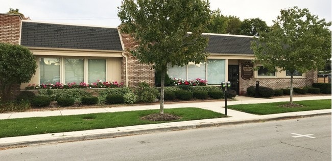
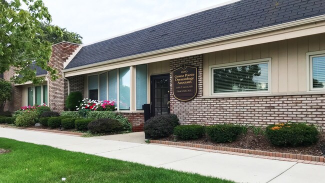
Property Record
18050 Mack Ave, Grosse Pointe, MI 48230

Property Detail
18050 Mack Ave
37-001-02-0566-000
CYB566 567 LOTS 566 AND 567 GROSSE POINTE COLONY SUB OF LOTS 16 17 27 33 ETC PC 299 300 458 L31 P97 WCR K 43.00
Medicalbuilding
Wayne
R-01
Michigan
B and X Area of moderate flood hazard, usually the area between the limits of the 100-year and 500-year floods.
0566
2025
0.08 AC
2025
The Pointes/Harper Woods
550500
Detroit
2,962 SF
Detroit-Warren-Dearborn, MI
NEARBY LISTINGS FOR SALE OR LEASE
DEMOGRAPHICS near 18050 Mack Ave
1 mile
3 mile
5 mile
2025 Total Population
16,785
113,133
237,156
2030 Population
16,548
113,607
240,944
Pop Growth 2025-2030
(1.41%)
+ 0.42%
+ 1.60%
Average Age
41
39
39
2025 Total Households
6,477
42,629
91,825
HH Growth 2025-2030
(1.47%)
+ 0.30%
+ 1.44%
Median Household Inc
$87,060
$64,134
$54,890
Avg Household Size
2.50
2.60
2.50
2025 Avg HH Vehicles
2.00
2.00
1.00
Median Home Value
$313,876
$224,277
$157,976
Median Year Built
1947
1949
1952
Nearby Places
Map Layers
Map Styles
 Street
 Aerial
Layers
 Traffic
 Biking
Places
Listings with unknown addresses are not visible on the map
- Restaurants
- Banks
- Shops
- Fitness
- Groceries
PUBLIC TRANSPORTATION
AIRPORT
Windsor International
Drive
Walk
Distance
Windsor International
44 min
21.7 mi
Detroit Metro Wayne County
Drive
Walk
Distance
Detroit Metro Wayne County
47 min
31.2 mi
Freight Ports
Drive
Walk
Distance
93 min
71.9 mi
SALE & LEASE HISTORY
LISTING DATE
SALE/LEASE

Oct 18, 2018
For Lease
Oct 09, 2019
For Sale
Nov 15, 2017
For Sale
Nearby Properties
Address
Land Use
TOTAL SIZE
Lot Size
Zoning
Address
Land Use
TOTAL SIZE
Lot Size
Zoning
211,065 SF
8.84 AC
C.F
Address
Land Use
TOTAL SIZE
Lot Size
Zoning
575,081 SF
8.53 AC
R6
Address
Land Use
TOTAL SIZE
Lot Size
Zoning
101,733 SF
1.10 AC
C-2
Address
Land Use
TOTAL SIZE
Lot Size
Zoning
49,437 SF
0.47 AC
Address
Land Use
TOTAL SIZE
Lot Size
Zoning
93,296 SF
1.05 AC
C-2
Address
Land Use
TOTAL SIZE
Lot Size
Zoning
62,195 SF
1.50 AC
Address
Land Use
TOTAL SIZE
Lot Size
Zoning
17,558 SF
3.15 AC
Address
Land Use
TOTAL SIZE
Lot Size
Zoning
41,000 SF
C-1
Address
Land Use
TOTAL SIZE
Lot Size
Zoning
41,235 SF
8.81 AC
Address
Land Use
TOTAL SIZE
Lot Size
Zoning
30,919 SF
0.86 AC
C
Address
Land Use
TOTAL SIZE
Lot Size
Zoning
28,055 SF
0.44 AC
Address
Land Use
TOTAL SIZE
Lot Size
Zoning
42,113 SF
0.54 AC
Address
Land Use
TOTAL SIZE
Lot Size
Zoning
102,205 SF
214.30 AC
Address
Land Use
TOTAL SIZE
Lot Size
Zoning
20,625 SF
0.48 AC
C-2
Address
Land Use
TOTAL SIZE
Lot Size
Zoning
47,227 SF
6.29 AC
PD
Address
Land Use
TOTAL SIZE
Lot Size
Zoning
10,704 SF
1.84 AC
Address
Land Use
TOTAL SIZE
Lot Size
Zoning
25,500 SF
0.23 AC
Address
Land Use
TOTAL SIZE
Lot Size
Zoning
101,814 SF
3.74 AC
R-2
Address
Land Use
TOTAL SIZE
Lot Size
Zoning
60,484 SF
4.85 AC
PD
Address
Land Use
TOTAL SIZE
Lot Size
Zoning
38,577 SF
1.91 AC
C
Address
Land Use
TOTAL SIZE
Lot Size
Zoning
43,967 SF
2.80 AC
O-1
Address
Land Use
TOTAL SIZE
Lot Size
Zoning
16.16 AC
PD
Address
Land Use
TOTAL SIZE
Lot Size
Zoning
14,820 SF
0.41 AC
C-1
Address
Land Use
TOTAL SIZE
Lot Size
Zoning
94,391 SF
128.65 AC
R-1A
Address
Land Use
TOTAL SIZE
Lot Size
Zoning
18,113 SF
0.42 AC
C-2
Address
Land Use
TOTAL SIZE
Lot Size
Zoning
6,152 SF
4.30 AC
Address
Land Use
TOTAL SIZE
Lot Size
Zoning
22,680 SF
1.28 AC
C
Address
Land Use
TOTAL SIZE
Lot Size
Zoning
24,120 SF
4.89 AC
B4
Address
Land Use
TOTAL SIZE
Lot Size
Zoning
10,630 SF
0.20 AC
C-2
Address
Land Use
TOTAL SIZE
Lot Size
Zoning
140,160 SF
0.62 AC
The World's #1 Commercial Real Estate Marketplace
Connect with us
© 2026 CoStar Group
The information above has been obtained from sources believed reliable. While we do not doubt its accuracy we have not verified it and make no guarantee, warranty or representation about it. It is your responsibility to independently confirm its accuracy and completeness. Any projections, opinions, assumptions, or estimates used are for example only and do not represent the current or future performance of the property. The value of this transaction to you depends on tax and other factors which should be evaluated by your tax, financial, and legal advisors. You and your advisors should conduct a careful, independent investigation of the property to determine to your satisfaction the suitability of the property for your needs.