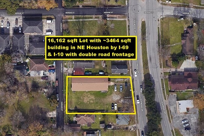
Property Record
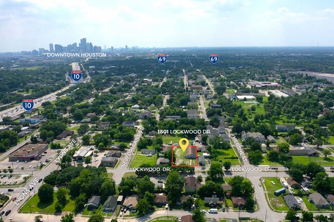
1806 Harlem St, Houston, TX 77020
NEARBY LISTINGS FOR SALE OR LEASE
Property Detail
1806 Harlem St
Houston-Pasadena-The Woodlands, TX
Englewood
0131350000003
LT 3 BLK 29 ENGLEWOOD
Commercialnec
Harris
X
Texas
48201C0690N
3
2024
0.12 AC
2025
I-10 East
211302
Houston
3,600 SF
DEMOGRAPHICS near 1806 Harlem St
1 mile
3 mile
5 mile
2024 Total Population
17,159
111,320
333,330
2029 Population
17,760
115,364
345,636
Pop Growth 2024-2029
+ 3.50%
+ 3.63%
+ 3.69%
Average Age
37
38
37
2024 Total Households
6,099
38,835
129,072
HH Growth 2024-2029
+ 3.61%
+ 4.14%
+ 4.05%
Median Household Inc
$36,223
$38,974
$52,605
Avg Household Size
2.70
2.50
2.40
2024 Avg HH Vehicles
2.00
1.00
2.00
Median Home Value
$119,152
$162,594
$226,206
Median Year Built
1958
1959
1967
Nearby Places
Map Layers
Map Styles
 Street
 Aerial
Transit
 Traffic
 Biking
Places
Listings with unknown addresses are not visible on the map
- Restaurants
- Banks
- Shops
- Fitness
- Groceries
PUBLIC TRANSPORTATION
COMMUTER RAIL
Houston (Sunset Limited - Amtrak)
Drive
Walk
Distance
Houston (Sunset Limited - Amtrak)
7 min
4.1 mi
AIRPORT
William P Hobby
Drive
Walk
Distance
William P Hobby
25 min
12.9 mi
George Bush Intcntl/Houston
Drive
Walk
Distance
George Bush Intcntl/Houston
25 min
17.8 mi
Freight Ports
Port of Houston
Drive
Walk
Distance
Port of Houston
14 min
7.2 mi
SALE & LEASE HISTORY
LISTING DATE
SALE/LEASE

Oct 08, 2019
For Sale
May 25, 2023
For Sale
Jun 01, 2022
For Sale
Aug 08, 2022
For Sale
Nearby Properties
Address
Land Use
TOTAL SIZE
Lot Size
Zoning
Address
Land Use
TOTAL SIZE
Lot Size
Zoning
100.26 AC
Address
Land Use
TOTAL SIZE
Lot Size
Zoning
12,206,592 SF
212.18 AC
Address
Land Use
TOTAL SIZE
Lot Size
Zoning
1,091,726 SF
2.60 AC
Address
Land Use
TOTAL SIZE
Lot Size
Zoning
934,258 SF
1.45 AC
Address
Land Use
TOTAL SIZE
Lot Size
Zoning
1,392,720 SF
83.75 AC
Address
Land Use
TOTAL SIZE
Lot Size
Zoning
396,910 SF
0.44 AC
Address
Land Use
TOTAL SIZE
Lot Size
Zoning
360,043 SF
0.81 AC
Address
Land Use
TOTAL SIZE
Lot Size
Zoning
575,578 SF
1.46 AC
Address
Land Use
TOTAL SIZE
Lot Size
Zoning
644,794 SF
3.38 AC
Address
Land Use
TOTAL SIZE
Lot Size
Zoning
587,515 SF
4.85 AC
Address
Land Use
TOTAL SIZE
Lot Size
Zoning
400,641 SF
1.86 AC
Address
Land Use
TOTAL SIZE
Lot Size
Zoning
406,772 SF
4.30 AC
Address
Land Use
TOTAL SIZE
Lot Size
Zoning
382,965 SF
1.45 AC
Address
Land Use
TOTAL SIZE
Lot Size
Zoning
793,077 SF
49.76 AC
Address
Land Use
TOTAL SIZE
Lot Size
Zoning
199,210 SF
1.44 AC
Address
Land Use
TOTAL SIZE
Lot Size
Zoning
463,768 SF
6.23 AC
Address
Land Use
TOTAL SIZE
Lot Size
Zoning
406,586 SF
4.03 AC
Address
Land Use
TOTAL SIZE
Lot Size
Zoning
186,808 SF
4.73 AC
Address
Land Use
TOTAL SIZE
Lot Size
Zoning
232,083 SF
0.72 AC
Address
Land Use
TOTAL SIZE
Lot Size
Zoning
171,600 SF
0.44 AC
Address
Land Use
TOTAL SIZE
Lot Size
Zoning
186,460 SF
1.45 AC
Address
Land Use
TOTAL SIZE
Lot Size
Zoning
Address
Land Use
TOTAL SIZE
Lot Size
Zoning
498,726 SF
4.97 AC
Address
Land Use
TOTAL SIZE
Lot Size
Zoning
901,984 SF
59.37 AC
Address
Land Use
TOTAL SIZE
Lot Size
Zoning
131,608 SF
1.09 AC
Address
Land Use
TOTAL SIZE
Lot Size
Zoning
923,370 SF
13.72 AC
Address
Land Use
TOTAL SIZE
Lot Size
Zoning
224,741 SF
10.75 AC
Address
Land Use
TOTAL SIZE
Lot Size
Zoning
111,415 SF
0.93 AC
Address
Land Use
TOTAL SIZE
Lot Size
Zoning
240,968 SF
12.45 AC
Address
Land Use
TOTAL SIZE
Lot Size
Zoning
923,370 SF
13.76 AC
The World's #1 Commercial Real Estate Marketplace
Connect with us
© 2026 CoStar Group
The information above has been obtained from sources believed reliable. While we do not doubt its accuracy we have not verified it and make no guarantee, warranty or representation about it. It is your responsibility to independently confirm its accuracy and completeness. Any projections, opinions, assumptions, or estimates used are for example only and do not represent the current or future performance of the property. The value of this transaction to you depends on tax and other factors which should be evaluated by your tax, financial, and legal advisors. You and your advisors should conduct a careful, independent investigation of the property to determine to your satisfaction the suitability of the property for your needs.