Property Record
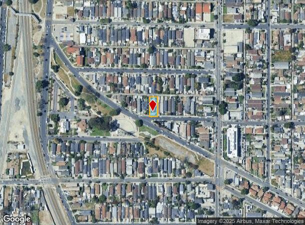
1807 E 107Th St, Los Angeles, CA 90002
This Property Is For Sale
NEARBY LISTINGS FOR SALE OR LEASE
Property Detail
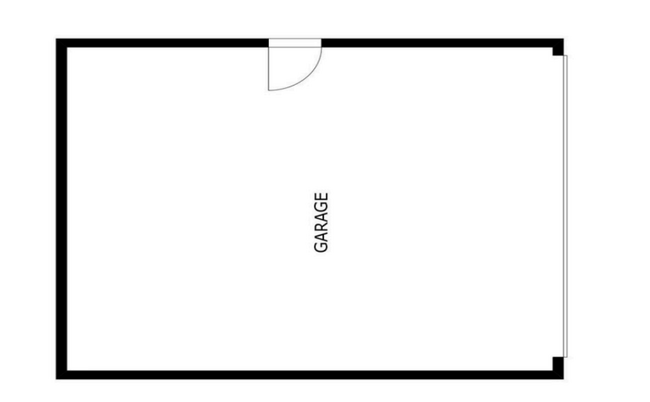
1807 E 107Th St
Los Angeles-Long Beach-Glendale, CA
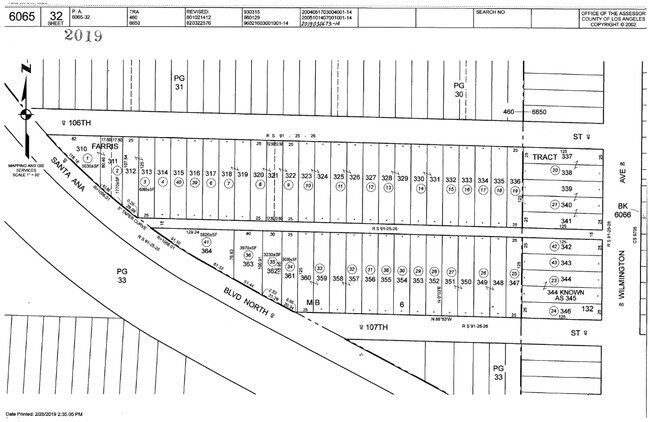
Farris Tract
6065-032-032
Los Angeles
Duplex
California
X
0.14 AC
06037C1805F
Watts
1,664 SF
Los Angeles
DEMOGRAPHICS near 1807 E 107Th St
1 Mile
3 Mile
5 Mile
2024 Total Population
47,893
409,143
950,685
2029 Population
45,715
390,413
909,524
Pop Growth 2024-2029
(4.55%)
(4.58%)
(4.33%)
Average Age
34
36
36
2024 Total Households
11,333
100,908
246,830
HH Growth 2024-2029
(5.14%)
(5.07%)
(4.76%)
Median Household Inc
$51,646
$64,261
$65,018
Avg Household Size
3.90
3.80
3.70
2024 Avg HH Vehicles
2.00
2.00
2.00
Median Home Value
$586,898
$657,569
$670,925
Median Year Built
1957
1953
1954
Nearby Places
Map Layers
Map Styles
 Street
 Aerial
- Restaurants
- Banks
- Shops
- Fitness
- Groceries
PUBLIC TRANSPORTATION
TRANSIT/SUBWAY
103rd Street Station (Blue Line - Los Angeles County Metropolitan Transportation Authority (Metro))
DRIVE
WALK
Distance
103rd Street Station (Blue Line - Los Angeles County Metropolitan Transportation Authority (Metro))
2 min
9 min
0.4 mi
Willowbrook/Rosa Parks Station (Blue Line - Los Angeles County Metropolitan Transportation Authority (Metro), Green Line - Los Angeles County Metropolitan Transportation Authority (Metro))
DRIVE
WALK
Distance
Willowbrook/Rosa Parks Station (Blue Line - Los Angeles County Metropolitan Transportation Authority (Metro), Green Line - Los Angeles County Metropolitan Transportation Authority (Metro))
5 min
17 min
0.9 mi
COMMUTER RAIL
DRIVE
WALK
Distance
19 min
8.8 mi
Union Station (91 Line - Southern California Regional Rail Authority (Metrolink), Antelope Valley Line - Southern California Regional Rail Authority (Metrolink), Orange County Line - Southern California Regional Rail Authority (Metrolink), Riverside Line - Southern California Regional Rail Authority (Metrolink), San Bernardino Line - Southern California Regional Rail Authority (Metrolink), Ventura County Line - Southern California Regional Rail Authority (Metrolink))
DRIVE
WALK
Distance
Union Station (91 Line - Southern California Regional Rail Authority (Metrolink), Antelope Valley Line - Southern California Regional Rail Authority (Metrolink), Orange County Line - Southern California Regional Rail Authority (Metrolink), Riverside Line - Southern California Regional Rail Authority (Metrolink), San Bernardino Line - Southern California Regional Rail Authority (Metrolink), Ventura County Line - Southern California Regional Rail Authority (Metrolink))
21 min
9.2 mi
AIRPORT
Los Angeles International
DRIVE
WALK
Distance
Los Angeles International
19 min
12.0 mi
Long Beach (Daugherty Field)
DRIVE
WALK
Distance
Long Beach (Daugherty Field)
23 min
14.3 mi
Bob Hope
DRIVE
WALK
Distance
Bob Hope
40 min
25.8 mi
Freight Ports
Port of Los Angeles
DRIVE
WALK
Distance
Port of Los Angeles
32 min
15.8 mi
Nearby Properties
Address
Land Use
TOTAL SIZE
Lot Size
Zoning
Address
Land Use
TOTAL SIZE
Lot Size
Zoning
587,291 SF
11.42 AC
LYHMD*
Address
Land Use
TOTAL SIZE
Lot Size
Zoning
248,531 SF
13.30 AC
LCM11/2-B1
Address
Land Use
TOTAL SIZE
Lot Size
Zoning
323,368 SF
15.18 AC
LYM*
Address
Land Use
TOTAL SIZE
Lot Size
Zoning
108,598 SF
15.93 AC
LCC3*
Address
Land Use
TOTAL SIZE
Lot Size
Zoning
248,925 SF
10.91 AC
LYCB1*
Address
Land Use
TOTAL SIZE
Lot Size
Zoning
37,867 SF
8.32 AC
COMH-B*
Address
Land Use
TOTAL SIZE
Lot Size
Zoning
515,047 SF
4.87 AC
COMH*
Address
Land Use
TOTAL SIZE
Lot Size
Zoning
116,728 SF
0.86 AC
HPCP*
Address
Land Use
TOTAL SIZE
Lot Size
Zoning
514,397 SF
24.34 AC
COMH-B*
Address
Land Use
TOTAL SIZE
Lot Size
Zoning
63,922 SF
1.82 AC
LCA16000*
Address
Land Use
TOTAL SIZE
Lot Size
Zoning
200,043 SF
8.68 AC
LYM*
Address
Land Use
TOTAL SIZE
Lot Size
Zoning
472,062 SF
24.39 AC
COMH-B*
Address
Land Use
TOTAL SIZE
Lot Size
Zoning
230,694 SF
9.02 AC
COMH-B*
Address
Land Use
TOTAL SIZE
Lot Size
Zoning
169,426 SF
3.50 AC
LCM11/2-B1
Address
Land Use
TOTAL SIZE
Lot Size
Zoning
498,163 SF
11.53 AC
LYM*
Address
Land Use
TOTAL SIZE
Lot Size
Zoning
127,484 SF
7.33 AC
LAM2
Address
Land Use
TOTAL SIZE
Lot Size
Zoning
104,291 SF
7.35 AC
LAR3
Address
Land Use
TOTAL SIZE
Lot Size
Zoning
134,514 SF
1.94 AC
LCM2*
Address
Land Use
TOTAL SIZE
Lot Size
Zoning
293,886 SF
4.98 AC
SGM3
Address
Land Use
TOTAL SIZE
Lot Size
Zoning
131,235 SF
6.70 AC
COMH*
Address
Land Use
TOTAL SIZE
Lot Size
Zoning
97,204 SF
4.10 AC
COMH*
Address
Land Use
TOTAL SIZE
Lot Size
Zoning
101,562 SF
7.53 AC
LAR3
Address
Land Use
TOTAL SIZE
Lot Size
Zoning
74,882 SF
5.25 AC
LYCB1*
Address
Land Use
TOTAL SIZE
Lot Size
Zoning
52,331 SF
4.17 AC
SG
Address
Land Use
TOTAL SIZE
Lot Size
Zoning
155,946 SF
6.58 AC
LYM*
Address
Land Use
TOTAL SIZE
Lot Size
Zoning
152,151 SF
3.59 AC
LCM2*
Address
Land Use
TOTAL SIZE
Lot Size
Zoning
61,653 SF
3.47 AC
LYCB1*
Address
Land Use
TOTAL SIZE
Lot Size
Zoning
241,095 SF
9.15 AC
COCL*
Address
Land Use
TOTAL SIZE
Lot Size
Zoning
589,061 SF
19.32 AC
SGM3
Address
Land Use
TOTAL SIZE
Lot Size
Zoning
31,436 SF
2.38 AC
LYC2*
The World's #1 Commercial Real Estate Marketplace
Connect with us
© 2026 CoStar Group
The information above has been obtained from sources believed reliable. While we do not doubt its accuracy we have not verified it and make no guarantee, warranty or representation about it. It is your responsibility to independently confirm its accuracy and completeness. Any projections, opinions, assumptions, or estimates used are for example only and do not represent the current or future performance of the property. The value of this transaction to you depends on tax and other factors which should be evaluated by your tax, financial, and legal advisors. You and your advisors should conduct a careful, independent investigation of the property to determine to your satisfaction the suitability of the property for your needs.