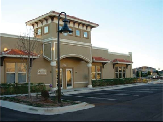
Property Record
1807 Short Branch Dr, New Port Richey, FL 34655
NEARBY LISTINGS FOR SALE OR LEASE
Property Detail
1807 Short Branch Dr
Tampa-St. Petersburg-Clearwater, FL
Fox Wood
31-26-17-0060-00000-00HA
FOXWOOD PHASE FIVE PB 9 PGS 108-117 POR OF TRACT H DESC AS COM AT NE COR OF TRACT H TH ALG NWLY BDY OF TRACT H S60DEG1909W 517.85 FT TO NW COR OF TRACT TH S29DEG4051E 333.94 FT TH DEPARTING SWLY BDY OF TRACT H N60DEG1949E 30.70 FT FOR POB TH N29DEG40
Officebuilding
Pasco
X
Florida
12101C0367F
ha
2024
0.07 AC
2025
Pasco County
031601
Tampa/St Petersburg
3,000 SF
DEMOGRAPHICS near 1807 Short Branch Dr
1 Mile
3 Mile
5 Mile
2024 Total Population
7,928
35,774
86,141
2029 Population
9,550
43,251
102,535
Pop Growth 2024-2029
+ 20.46%
+ 20.90%
+ 19.03%
Average Age
45
42
43
2024 Total Households
3,048
13,852
34,018
HH Growth 2024-2029
+ 20.44%
+ 20.86%
+ 19.03%
Median Household Inc
$98,167
$90,476
$81,366
Avg Household Size
2.60
2.60
2.50
2024 Avg HH Vehicles
2.00
2.00
2.00
Median Home Value
$375,315
$348,218
$329,791
Median Year Built
2006
2004
1996
Nearby Places
Map Layers
Map Styles
 Street
 Aerial
- Restaurants
- Banks
- Shops
- Fitness
- Groceries
PUBLIC TRANSPORTATION
AIRPORT
Tampa International
DRIVE
WALK
Distance
Tampa International
38 min
26.0 mi
St Pete-Clearwater International
DRIVE
WALK
Distance
St Pete-Clearwater International
48 min
27.0 mi
Freight Ports
Port of Tampa Bay
DRIVE
WALK
Distance
Port of Tampa Bay
50 min
31.5 mi
Nearby Properties
Address
Land Use
TOTAL SIZE
Lot Size
Zoning
Address
Land Use
TOTAL SIZE
Lot Size
Zoning
430,820 SF
19.14 AC
MPUD
Address
Land Use
TOTAL SIZE
Lot Size
Zoning
417,700 SF
28.91 AC
MPUD
Address
Land Use
TOTAL SIZE
Lot Size
Zoning
339,446 SF
16.29 AC
MPUD
Address
Land Use
TOTAL SIZE
Lot Size
Zoning
290,535 SF
14.91 AC
MPUD
Address
Land Use
TOTAL SIZE
Lot Size
Zoning
403,054 SF
117.69 AC
MPUD
Address
Land Use
TOTAL SIZE
Lot Size
Zoning
203,571 SF
13.82 AC
C2
Address
Land Use
TOTAL SIZE
Lot Size
Zoning
190,854 SF
14.90 AC
MPUD
Address
Land Use
TOTAL SIZE
Lot Size
Zoning
143,332 SF
17.40 AC
C2
Address
Land Use
TOTAL SIZE
Lot Size
Zoning
152,300 SF
2.82 AC
MF3
Address
Land Use
TOTAL SIZE
Lot Size
Zoning
1,017 AC
AR
Address
Land Use
TOTAL SIZE
Lot Size
Zoning
113,034 SF
15.21 AC
MPUD
Address
Land Use
TOTAL SIZE
Lot Size
Zoning
654.52 AC
AR
Address
Land Use
TOTAL SIZE
Lot Size
Zoning
114,831 SF
7.98 AC
MF2
Address
Land Use
TOTAL SIZE
Lot Size
Zoning
59,874 SF
7.73 AC
MPUD
Address
Land Use
TOTAL SIZE
Lot Size
Zoning
116,607 SF
3.88 AC
MPUD
Address
Land Use
TOTAL SIZE
Lot Size
Zoning
83,958 SF
18.56 AC
MPUD
Address
Land Use
TOTAL SIZE
Lot Size
Zoning
80,957 SF
17.71 AC
MPUD
Address
Land Use
TOTAL SIZE
Lot Size
Zoning
70,248 SF
27.90 AC
R4
Address
Land Use
TOTAL SIZE
Lot Size
Zoning
89,242 SF
14.28 AC
MPUD
Address
Land Use
TOTAL SIZE
Lot Size
Zoning
217,376 SF
22.12 AC
C2
Address
Land Use
TOTAL SIZE
Lot Size
Zoning
53,744 SF
10.64 AC
MPUD
Address
Land Use
TOTAL SIZE
Lot Size
Zoning
61,760 SF
11.47 AC
MPUD
Address
Land Use
TOTAL SIZE
Lot Size
Zoning
245.25 AC
PRM
Address
Land Use
TOTAL SIZE
Lot Size
Zoning
85,547 SF
16.13 AC
MPUD
Address
Land Use
TOTAL SIZE
Lot Size
Zoning
109,894 SF
7.95 AC
C2
Address
Land Use
TOTAL SIZE
Lot Size
Zoning
106,039 SF
3.03 AC
MPUD
Address
Land Use
TOTAL SIZE
Lot Size
Zoning
74,679 SF
5.93 AC
MPUD
Address
Land Use
TOTAL SIZE
Lot Size
Zoning
85,600 SF
13.40 AC
C2
Address
Land Use
TOTAL SIZE
Lot Size
Zoning
89,308 SF
0.58 AC
C2
The World's #1 Commercial Real Estate Marketplace
Connect with us
© 2025 CoStar Group
The information above has been obtained from sources believed reliable. While we do not doubt its accuracy we have not verified it and make no guarantee, warranty or representation about it. It is your responsibility to independently confirm its accuracy and completeness. Any projections, opinions, assumptions, or estimates used are for example only and do not represent the current or future performance of the property. The value of this transaction to you depends on tax and other factors which should be evaluated by your tax, financial, and legal advisors. You and your advisors should conduct a careful, independent investigation of the property to determine to your satisfaction the suitability of the property for your needs.