Property Record
18071 Territorial Rd, Maple Grove, MN 55369

NEARBY LISTINGS FOR SALE OR LEASE
Property Detail
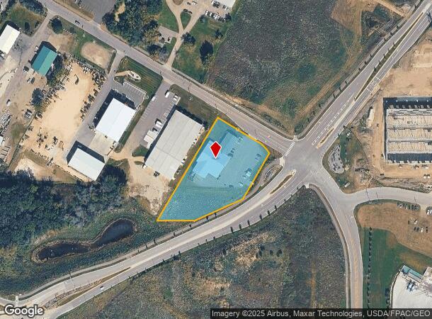
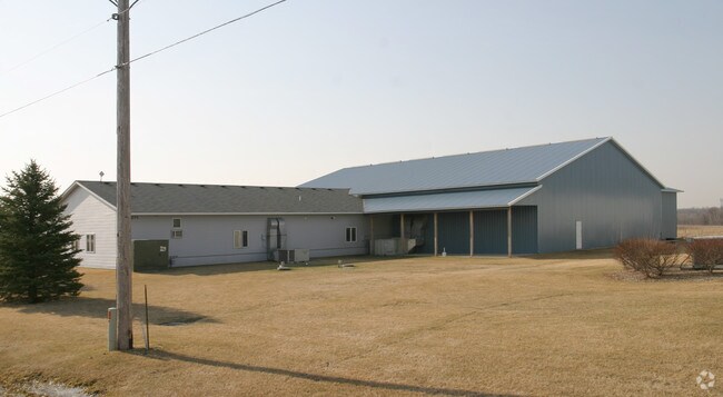
18071 Territorial Rd
Minneapolis-St. Paul-Bloomington, MN-WI
Vf13 Addn
31-120-22-13-0018
LOT 002 BLOCK 001 A VF13 ADDN LOT 2 BLOCK 1 EXCEPT THAT PART LYING SOUTHERLY OF A LINE RUN FROM A POINT ON THE SOUTHERLY LINE OF SAID LOT 2 DISTANT 137.57 FEET WESTERLY OF THE T IRREGULAR
Industrialgeneral
Hennepin
X
Minnesota
27053C0045F
2
2024
2.07 AC
2024
Northwest
026910
Minneapolis/St Paul
DEMOGRAPHICS near 18071 Territorial Rd
1 Mile
3 Mile
5 Mile
2024 Total Population
1,580
15,871
61,028
2029 Population
1,588
15,722
60,546
Pop Growth 2024-2029
+ 0.51%
(0.94%)
(0.79%)
Average Age
37
39
40
2024 Total Households
540
5,849
21,891
HH Growth 2024-2029
+ 0.19%
(1.16%)
(0.99%)
Median Household Inc
$124,544
$120,146
$124,210
Avg Household Size
2.90
2.70
2.70
2024 Avg HH Vehicles
2.00
2.00
2.00
Median Home Value
$455,586
$412,084
$381,357
Median Year Built
2010
1999
1994
Nearby Places
Map Layers
Map Styles
 Street
 Aerial
- Restaurants
- Banks
- Shops
- Fitness
- Groceries
PUBLIC TRANSPORTATION
COMMUTER RAIL
Anoka Station (Northstar Corridor - Northstar Commuter Rail)
DRIVE
WALK
Distance
Anoka Station (Northstar Corridor - Northstar Commuter Rail)
20 min
9.3 mi
AIRPORT
Minneapolis-St Paul International/Wold-Chamberlain
DRIVE
WALK
Distance
Minneapolis-St Paul International/Wold-Chamberlain
45 min
33.9 mi
SALE & LEASE HISTORY
LISTING DATE
SALE/LEASE

Sep 24, 2016
For Sale
Nearby Properties
Address
Land Use
TOTAL SIZE
Lot Size
Zoning
Address
Land Use
TOTAL SIZE
Lot Size
Zoning
4.33 AC
Address
Land Use
TOTAL SIZE
Lot Size
Zoning
42.21 AC
Address
Land Use
TOTAL SIZE
Lot Size
Zoning
25.06 AC
Address
Land Use
TOTAL SIZE
Lot Size
Zoning
36.67 AC
Address
Land Use
TOTAL SIZE
Lot Size
Zoning
21.50 AC
Address
Land Use
TOTAL SIZE
Lot Size
Zoning
30.13 AC
Address
Land Use
TOTAL SIZE
Lot Size
Zoning
Address
Land Use
TOTAL SIZE
Lot Size
Zoning
Address
Land Use
TOTAL SIZE
Lot Size
Zoning
Address
Land Use
TOTAL SIZE
Lot Size
Zoning
22.24 AC
Address
Land Use
TOTAL SIZE
Lot Size
Zoning
228,208 SF
24.92 AC
Address
Land Use
TOTAL SIZE
Lot Size
Zoning
62.34 AC
Address
Land Use
TOTAL SIZE
Lot Size
Zoning
24.34 AC
Address
Land Use
TOTAL SIZE
Lot Size
Zoning
21.02 AC
Address
Land Use
TOTAL SIZE
Lot Size
Zoning
30.91 AC
Address
Land Use
TOTAL SIZE
Lot Size
Zoning
15.20 AC
Address
Land Use
TOTAL SIZE
Lot Size
Zoning
10.44 AC
Address
Land Use
TOTAL SIZE
Lot Size
Zoning
132,200 SF
28.23 AC
Address
Land Use
TOTAL SIZE
Lot Size
Zoning
17.09 AC
Address
Land Use
TOTAL SIZE
Lot Size
Zoning
17.13 AC
Address
Land Use
TOTAL SIZE
Lot Size
Zoning
Address
Land Use
TOTAL SIZE
Lot Size
Zoning
15.15 AC
Address
Land Use
TOTAL SIZE
Lot Size
Zoning
20.09 AC
Address
Land Use
TOTAL SIZE
Lot Size
Zoning
Address
Land Use
TOTAL SIZE
Lot Size
Zoning
218,144 SF
3.71 AC
Address
Land Use
TOTAL SIZE
Lot Size
Zoning
16.57 AC
Address
Land Use
TOTAL SIZE
Lot Size
Zoning
12.98 AC
Address
Land Use
TOTAL SIZE
Lot Size
Zoning
13.21 AC
Address
Land Use
TOTAL SIZE
Lot Size
Zoning
11.61 AC
Address
Land Use
TOTAL SIZE
Lot Size
Zoning
10.26 AC
The World's #1 Commercial Real Estate Marketplace
Connect with us
© 2025 CoStar Group
The information above has been obtained from sources believed reliable. While we do not doubt its accuracy we have not verified it and make no guarantee, warranty or representation about it. It is your responsibility to independently confirm its accuracy and completeness. Any projections, opinions, assumptions, or estimates used are for example only and do not represent the current or future performance of the property. The value of this transaction to you depends on tax and other factors which should be evaluated by your tax, financial, and legal advisors. You and your advisors should conduct a careful, independent investigation of the property to determine to your satisfaction the suitability of the property for your needs.