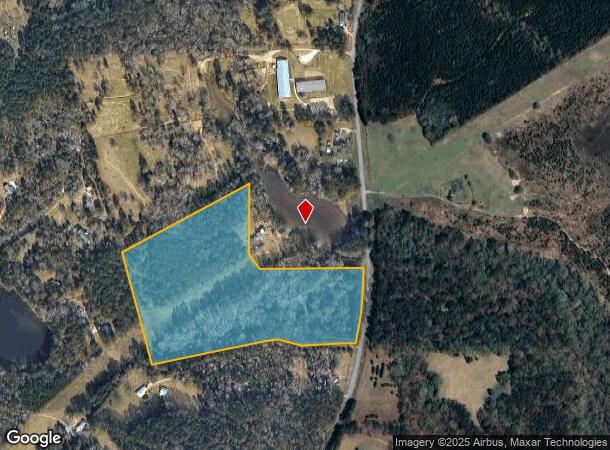
Property Record
1808 Costley Mill Rd Ne, Conyers, GA 30013
NEARBY LISTINGS FOR SALE OR LEASE
Property Detail
1808 Costley Mill Rd Ne
Atlanta-Sandy Springs-Roswell, GA
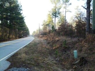
Rural
087-0-01-007B
&LL394 W/SIDE COSTLEY MILL RD
Privatepreserveopenspacevacantlandforestlandconservation
Rockdale
A
Georgia
13247C0110D
383
2024
24.06 AC
2024
I-20 East/Conyers
060104
Atlanta
DEMOGRAPHICS near 1808 Costley Mill Rd Ne
1 Mile
3 Mile
5 Mile
2024 Total Population
505
9,712
36,780
2029 Population
528
10,283
39,185
Pop Growth 2024-2029
+ 4.55%
+ 5.88%
+ 6.54%
Average Age
41
41
40
2024 Total Households
178
3,374
13,156
HH Growth 2024-2029
+ 5.06%
+ 6.05%
+ 6.59%
Median Household Inc
$123,957
$83,987
$67,716
Avg Household Size
2.80
2.80
2.70
2024 Avg HH Vehicles
2.00
2.00
2.00
Median Home Value
$323,636
$261,284
$218,619
Median Year Built
1996
1994
1992
Nearby Places
Map Layers
Map Styles
 Street
 Aerial
- Restaurants
- Banks
- Shops
- Fitness
- Groceries
PUBLIC TRANSPORTATION
AIRPORT
Hartsfield - Jackson Atlanta International
DRIVE
WALK
Distance
Hartsfield - Jackson Atlanta International
50 min
36.2 mi
Freight Ports
Georgia Ports - Savannah
DRIVE
WALK
Distance
Georgia Ports - Savannah
286 min
242.2 mi
Nearby Properties
Address
Land Use
TOTAL SIZE
Lot Size
Zoning
Address
Land Use
TOTAL SIZE
Lot Size
Zoning
362,852 SF
18.42 AC
RM24
Address
Land Use
TOTAL SIZE
Lot Size
Zoning
7,806 SF
32.76 AC
RM
Address
Land Use
TOTAL SIZE
Lot Size
Zoning
5,902 SF
903.52 AC
RES AG
Address
Land Use
TOTAL SIZE
Lot Size
Zoning
180,890 SF
45.15 AC
R1
Address
Land Use
TOTAL SIZE
Lot Size
Zoning
180,000 SF
12.37 AC
ID
Address
Land Use
TOTAL SIZE
Lot Size
Zoning
286.57 AC
RES AG
Address
Land Use
TOTAL SIZE
Lot Size
Zoning
71.95 AC
R1
Address
Land Use
TOTAL SIZE
Lot Size
Zoning
66,181 SF
25.46 AC
R1A
Address
Land Use
TOTAL SIZE
Lot Size
Zoning
7,020 SF
29.06 AC
RES AG
Address
Land Use
TOTAL SIZE
Lot Size
Zoning
6,426 SF
100 AC
R1
Address
Land Use
TOTAL SIZE
Lot Size
Zoning
11,000 SF
56.32 AC
R3/C
Address
Land Use
TOTAL SIZE
Lot Size
Zoning
6,976 SF
4 AC
RES AG
Address
Land Use
TOTAL SIZE
Lot Size
Zoning
13,900 SF
1.19 AC
ID
Address
Land Use
TOTAL SIZE
Lot Size
Zoning
38.50 AC
R3C2C1OI(C
Address
Land Use
TOTAL SIZE
Lot Size
Zoning
8,433 SF
2.18 AC
C1/C
Address
Land Use
TOTAL SIZE
Lot Size
Zoning
8,997 SF
4.03 AC
AR
Address
Land Use
TOTAL SIZE
Lot Size
Zoning
238 AC
AR
Address
Land Use
TOTAL SIZE
Lot Size
Zoning
10,493 SF
11.96 AC
R1/R1A
Address
Land Use
TOTAL SIZE
Lot Size
Zoning
28.24 AC
RES AG
Address
Land Use
TOTAL SIZE
Lot Size
Zoning
170 AC
WP
Address
Land Use
TOTAL SIZE
Lot Size
Zoning
151.99 AC
AR
Address
Land Use
TOTAL SIZE
Lot Size
Zoning
130.99 AC
AR
Address
Land Use
TOTAL SIZE
Lot Size
Zoning
2,040 SF
1.25 AC
WP
Address
Land Use
TOTAL SIZE
Lot Size
Zoning
113.73 AC
WP
Address
Land Use
TOTAL SIZE
Lot Size
Zoning
60.27 AC
AR
Address
Land Use
TOTAL SIZE
Lot Size
Zoning
113 AC
WP
Address
Land Use
TOTAL SIZE
Lot Size
Zoning
120.28 AC
R1/COND
Address
Land Use
TOTAL SIZE
Lot Size
Zoning
152.49 AC
AR
Address
Land Use
TOTAL SIZE
Lot Size
Zoning
8,098 SF
5.33 AC
WP
Address
Land Use
TOTAL SIZE
Lot Size
Zoning
104.98 AC
AR/WP
The World's #1 Commercial Real Estate Marketplace
Connect with us
© 2025 CoStar Group
The information above has been obtained from sources believed reliable. While we do not doubt its accuracy we have not verified it and make no guarantee, warranty or representation about it. It is your responsibility to independently confirm its accuracy and completeness. Any projections, opinions, assumptions, or estimates used are for example only and do not represent the current or future performance of the property. The value of this transaction to you depends on tax and other factors which should be evaluated by your tax, financial, and legal advisors. You and your advisors should conduct a careful, independent investigation of the property to determine to your satisfaction the suitability of the property for your needs.