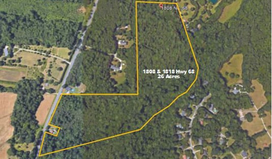
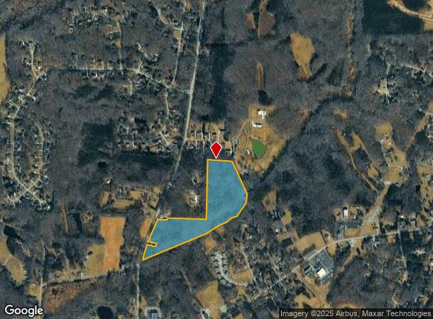
Property Record
1808 Nc Highway 68 N, Oak Ridge, NC 27310
NEARBY LISTINGS FOR SALE OR LEASE
-
-
View all Oak Ridge listings for sale on LoopNet.com
Property Detail
1808 Nc Highway 68 N
Greensboro-High Point, NC
Whitaker
0166094
27 AC WHITAKER R/C 63
Governmentalpublicusegeneral
Guilford
X
North Carolina
3710780800J
27
0
27 AC
2025
NW Guilford County
015902
Greensboro/Winston-Salem
DEMOGRAPHICS near 1808 Nc Highway 68 N
1 Mile
3 Mile
5 Mile
2024 Total Population
1,339
11,868
37,556
2029 Population
1,345
11,937
37,827
Pop Growth 2024-2029
+ 0.45%
+ 0.58%
+ 0.72%
Average Age
40
40
40
2024 Total Households
458
4,111
13,696
HH Growth 2024-2029
+ 0.44%
+ 0.61%
+ 0.75%
Median Household Inc
$136,979
$129,423
$102,236
Avg Household Size
2.90
2.90
2.70
2024 Avg HH Vehicles
3.00
3.00
2.00
Median Home Value
$422,826
$419,593
$325,062
Median Year Built
1997
1998
1995
Nearby Places
Map Layers
Map Styles
 Street
 Aerial
- Restaurants
- Banks
- Shops
- Fitness
- Groceries
PUBLIC TRANSPORTATION
AIRPORT
Piedmont Triad International
DRIVE
WALK
Distance
Piedmont Triad International
21 min
11.8 mi
Freight Ports
Virginia Port Authority - Richmond
DRIVE
WALK
Distance
Virginia Port Authority - Richmond
250 min
215.6 mi
SALE & LEASE HISTORY
LISTING DATE
SALE/LEASE

Nov 04, 2020
For Sale
Feb 19, 2019
For Sale
Nearby Properties
Address
Land Use
TOTAL SIZE
Lot Size
Zoning
Address
Land Use
TOTAL SIZE
Lot Size
Zoning
169,401 SF
30.89 AC
PI
Address
Land Use
TOTAL SIZE
Lot Size
Zoning
254,857 SF
82.98 AC
PI
Address
Land Use
TOTAL SIZE
Lot Size
Zoning
22,757 SF
94.40 AC
PI
Address
Land Use
TOTAL SIZE
Lot Size
Zoning
100,320 SF
13.16 AC
SC
Address
Land Use
TOTAL SIZE
Lot Size
Zoning
25,755 SF
509.95 AC
AG
Address
Land Use
TOTAL SIZE
Lot Size
Zoning
50,853 SF
23.39 AC
CD-HB
Address
Land Use
TOTAL SIZE
Lot Size
Zoning
0.77 AC
CU-SC
Address
Land Use
TOTAL SIZE
Lot Size
Zoning
21,768 SF
3.06 AC
CU-SC
Address
Land Use
TOTAL SIZE
Lot Size
Zoning
20,418 SF
31.84 AC
PI
Address
Land Use
TOTAL SIZE
Lot Size
Zoning
16,445 SF
2.69 AC
CU-GO-M
Address
Land Use
TOTAL SIZE
Lot Size
Zoning
8,336 SF
4.01 AC
CU-LB
Address
Land Use
TOTAL SIZE
Lot Size
Zoning
5,761 SF
39.01 AC
PI
Address
Land Use
TOTAL SIZE
Lot Size
Zoning
10,820 SF
1.95 AC
CU-GB
Address
Land Use
TOTAL SIZE
Lot Size
Zoning
4,692 SF
1.17 AC
CU-SC
Address
Land Use
TOTAL SIZE
Lot Size
Zoning
3,715 SF
1.34 AC
CU-GO-M
Address
Land Use
TOTAL SIZE
Lot Size
Zoning
66.19 AC
PI
Address
Land Use
TOTAL SIZE
Lot Size
Zoning
116.65 AC
AG
Address
Land Use
TOTAL SIZE
Lot Size
Zoning
4,237 SF
10.82 AC
GO-M
Address
Land Use
TOTAL SIZE
Lot Size
Zoning
3,594 SF
1.15 AC
SC
Address
Land Use
TOTAL SIZE
Lot Size
Zoning
115.46 AC
AG
Address
Land Use
TOTAL SIZE
Lot Size
Zoning
13,872 SF
1.96 AC
GO-M
Address
Land Use
TOTAL SIZE
Lot Size
Zoning
9,287 SF
1.66 AC
CU-SC
Address
Land Use
TOTAL SIZE
Lot Size
Zoning
4,398 SF
76.58 AC
AG
Address
Land Use
TOTAL SIZE
Lot Size
Zoning
14,350 SF
1.45 AC
LB
Address
Land Use
TOTAL SIZE
Lot Size
Zoning
3,874 SF
1.74 AC
CU-SC
Address
Land Use
TOTAL SIZE
Lot Size
Zoning
4,950 SF
52.58 AC
AG
Address
Land Use
TOTAL SIZE
Lot Size
Zoning
14,023 SF
6.38 AC
AG
Address
Land Use
TOTAL SIZE
Lot Size
Zoning
6,675 SF
1.20 AC
SC
Address
Land Use
TOTAL SIZE
Lot Size
Zoning
14,922 SF
6 AC
RS-30
Address
Land Use
TOTAL SIZE
Lot Size
Zoning
10,432 SF
1.02 AC
CU-GO-M
The World's #1 Commercial Real Estate Marketplace
Connect with us
© 2026 CoStar Group
The information above has been obtained from sources believed reliable. While we do not doubt its accuracy we have not verified it and make no guarantee, warranty or representation about it. It is your responsibility to independently confirm its accuracy and completeness. Any projections, opinions, assumptions, or estimates used are for example only and do not represent the current or future performance of the property. The value of this transaction to you depends on tax and other factors which should be evaluated by your tax, financial, and legal advisors. You and your advisors should conduct a careful, independent investigation of the property to determine to your satisfaction the suitability of the property for your needs.