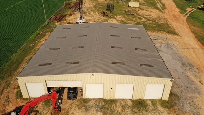
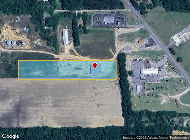
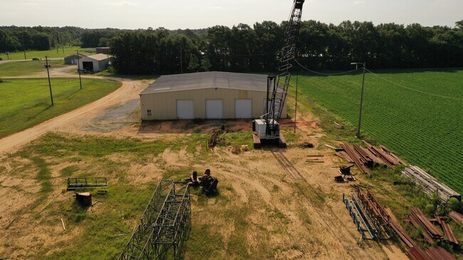
Property Record
Highway 21, Atmore, AL 36502
Current Lease Availabilities
NEARBY LISTINGS FOR SALE OR LEASE
Property Detail
Highway 21
26-09-32-3-003-005.005
BEG 109.01 W & 531.29 S OF INT N LINE OF SW1 4 OF S32- T1N-R6E & W R W US HWY 21; TH S 203.29 ; W 1071.37 ; N 203.89 ; E 1071.37 TO POB. CN TG 5 AC(C)
Servicestation
Escambia
X
Alabama
01053C0605F
5 AC
2025
Alabama South Area
2024
Other Market Areas
970500
Atmore, AL
10,000 SF
DEMOGRAPHICS near Highway 21
1 Mile
3 Mile
5 Mile
2024 Total Population
786
7,732
10,832
2029 Population
778
7,641
10,715
Pop Growth 2024-2029
(1.02%)
(1.18%)
(1.08%)
Average Age
42
40
41
2024 Total Households
319
3,256
4,509
HH Growth 2024-2029
(1.25%)
(1.20%)
(1.09%)
Median Household Inc
$37,500
$31,781
$34,059
Avg Household Size
2.40
2.30
2.30
2024 Avg HH Vehicles
2.00
1.00
2.00
Median Home Value
$149,137
$123,131
$122,474
Median Year Built
1977
1982
1983
Nearby Places
Map Layers
Map Styles
 Street
 Aerial
- Restaurants
- Banks
- Shops
- Fitness
- Groceries
Nearby Properties
Address
Land Use
TOTAL SIZE
Lot Size
Zoning
Address
Land Use
TOTAL SIZE
Lot Size
Zoning
75,361 SF
55 AC
Address
Land Use
TOTAL SIZE
Lot Size
Zoning
100,422 SF
17.73 AC
AGR
Address
Land Use
TOTAL SIZE
Lot Size
Zoning
10,037 SF
40 AC
AGR
Address
Land Use
TOTAL SIZE
Lot Size
Zoning
86,400 SF
4 AC
Address
Land Use
TOTAL SIZE
Lot Size
Zoning
157,440 SF
5 AC
Address
Land Use
TOTAL SIZE
Lot Size
Zoning
44,142 SF
15.75 AC
RMU
Address
Land Use
TOTAL SIZE
Lot Size
Zoning
68,788 SF
14 AC
Address
Land Use
TOTAL SIZE
Lot Size
Zoning
13,652 SF
6 AC
Address
Land Use
TOTAL SIZE
Lot Size
Zoning
102,000 SF
15 AC
Address
Land Use
TOTAL SIZE
Lot Size
Zoning
13,555 SF
4.90 AC
RMU
Address
Land Use
TOTAL SIZE
Lot Size
Zoning
3,920 SF
59.90 AC
AGR
Address
Land Use
TOTAL SIZE
Lot Size
Zoning
63,750 SF
25 AC
Address
Land Use
TOTAL SIZE
Lot Size
Zoning
10,560 SF
5.81 AC
AGR
Address
Land Use
TOTAL SIZE
Lot Size
Zoning
31,267 SF
6.17 AC
Address
Land Use
TOTAL SIZE
Lot Size
Zoning
12,696 SF
2.56 AC
Address
Land Use
TOTAL SIZE
Lot Size
Zoning
110,046 SF
4 AC
Address
Land Use
TOTAL SIZE
Lot Size
Zoning
11,086 SF
5 AC
AGR,RMU
Address
Land Use
TOTAL SIZE
Lot Size
Zoning
84,000 SF
2 AC
Address
Land Use
TOTAL SIZE
Lot Size
Zoning
4,719 SF
120 AC
AGR
Address
Land Use
TOTAL SIZE
Lot Size
Zoning
93,780 SF
10 AC
Address
Land Use
TOTAL SIZE
Lot Size
Zoning
3,513 SF
45 AC
Address
Land Use
TOTAL SIZE
Lot Size
Zoning
4,642 SF
19.97 AC
AGR
Address
Land Use
TOTAL SIZE
Lot Size
Zoning
8,826 SF
7.61 AC
Address
Land Use
TOTAL SIZE
Lot Size
Zoning
17,230 SF
38 AC
Address
Land Use
TOTAL SIZE
Lot Size
Zoning
36,788 SF
15 AC
Address
Land Use
TOTAL SIZE
Lot Size
Zoning
22,260 SF
5 AC
Address
Land Use
TOTAL SIZE
Lot Size
Zoning
2,560 SF
50 AC
AGR
Address
Land Use
TOTAL SIZE
Lot Size
Zoning
27,378 SF
3.64 AC
Address
Land Use
TOTAL SIZE
Lot Size
Zoning
13,846 SF
0.52 AC
Address
Land Use
TOTAL SIZE
Lot Size
Zoning
85,443 SF
15 AC
The World's #1 Commercial Real Estate Marketplace
Connect with us
© 2026 CoStar Group
The information above has been obtained from sources believed reliable. While we do not doubt its accuracy we have not verified it and make no guarantee, warranty or representation about it. It is your responsibility to independently confirm its accuracy and completeness. Any projections, opinions, assumptions, or estimates used are for example only and do not represent the current or future performance of the property. The value of this transaction to you depends on tax and other factors which should be evaluated by your tax, financial, and legal advisors. You and your advisors should conduct a careful, independent investigation of the property to determine to your satisfaction the suitability of the property for your needs.