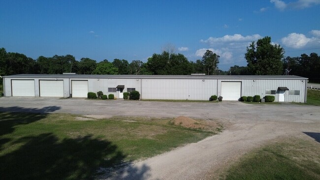
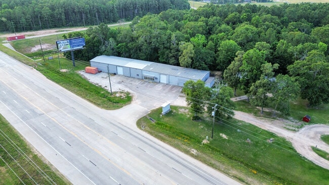
Property Record
18083 Fm 1314 Rd, Conroe, TX 77302


NEARBY LISTINGS FOR SALE OR LEASE
Property Detail
18083 Fm 1314 Rd
0333-00-00224
Lamonthe S V
Commercialnec
A0333 - LAMONTHE S V, TRACT 2B1-A, ACRES 1.5038
X
Montgomery
48339C0575G
Texas
2024
1.50 AC
2025
The Woodlands/Conroe
692202
Houston
7,800 SF
Houston-Pasadena-The Woodlands, TX
DEMOGRAPHICS near 18083 Fm 1314 Rd
1 mile
3 mile
5 mile
2024 Total Population
423
10,501
42,119
2029 Population
520
13,003
51,954
Pop Growth 2024-2029
+ 22.93%
+ 23.83%
+ 23.35%
Average Age
36
36
35
2024 Total Households
124
3,265
13,165
HH Growth 2024-2029
+ 23.39%
+ 23.92%
+ 23.52%
Median Household Inc
$92,105
$82,885
$91,504
Avg Household Size
3.20
3.10
3.10
2024 Avg HH Vehicles
3.00
2.00
2.00
Median Home Value
$312,264
$195,108
$243,014
Median Year Built
1992
2000
2006
Nearby Places
Map Layers
Map Styles
 Street
 Aerial
Transit
 Traffic
 Biking
Places
Listings with unknown addresses are not visible on the map
- Restaurants
- Banks
- Shops
- Fitness
- Groceries
PUBLIC TRANSPORTATION
AIRPORT
George Bush Intcntl/Houston
Drive
Walk
Distance
George Bush Intcntl/Houston
36 min
28.1 mi
SALE & LEASE HISTORY
LISTING DATE
SALE/LEASE

Nov 14, 2019
For Lease
Jan 25, 2019
For Lease
Apr 12, 2025
For Lease
Nearby Properties
Address
Land Use
TOTAL SIZE
Lot Size
Zoning
Address
Land Use
TOTAL SIZE
Lot Size
Zoning
95,185 SF
10.48 AC
1
Address
Land Use
TOTAL SIZE
Lot Size
Zoning
96,946 SF
12 AC
1
Address
Land Use
TOTAL SIZE
Lot Size
Zoning
86,584 SF
5.58 AC
Address
Land Use
TOTAL SIZE
Lot Size
Zoning
10,395 SF
3.20 AC
1
Address
Land Use
TOTAL SIZE
Lot Size
Zoning
22,776 SF
49.77 AC
Address
Land Use
TOTAL SIZE
Lot Size
Zoning
32,730 SF
4.41 AC
Address
Land Use
TOTAL SIZE
Lot Size
Zoning
8,320 SF
5.46 AC
1
Address
Land Use
TOTAL SIZE
Lot Size
Zoning
26,558 SF
12 AC
1
Address
Land Use
TOTAL SIZE
Lot Size
Zoning
11,200 SF
1.29 AC
Address
Land Use
TOTAL SIZE
Lot Size
Zoning
6,304 SF
4.82 AC
5
Address
Land Use
TOTAL SIZE
Lot Size
Zoning
29,314 SF
1.34 AC
1
Address
Land Use
TOTAL SIZE
Lot Size
Zoning
7,728 SF
2.56 AC
5
Address
Land Use
TOTAL SIZE
Lot Size
Zoning
9,146 SF
1.64 AC
1
Address
Land Use
TOTAL SIZE
Lot Size
Zoning
5,820 SF
2.39 AC
1
Address
Land Use
TOTAL SIZE
Lot Size
Zoning
1,440 SF
12.81 AC
1
Address
Land Use
TOTAL SIZE
Lot Size
Zoning
6,505 SF
16.82 AC
1
Address
Land Use
TOTAL SIZE
Lot Size
Zoning
12,880 SF
5.86 AC
1
Address
Land Use
TOTAL SIZE
Lot Size
Zoning
31.63 AC
Address
Land Use
TOTAL SIZE
Lot Size
Zoning
9,482 SF
5.51 AC
5
Address
Land Use
TOTAL SIZE
Lot Size
Zoning
20,808 SF
14.80 AC
1
Address
Land Use
TOTAL SIZE
Lot Size
Zoning
5,438 SF
9.16 AC
1
Address
Land Use
TOTAL SIZE
Lot Size
Zoning
8,926 SF
4.96 AC
Address
Land Use
TOTAL SIZE
Lot Size
Zoning
1,890 SF
11.56 AC
1
Address
Land Use
TOTAL SIZE
Lot Size
Zoning
12,096 SF
1.27 AC
5
Address
Land Use
TOTAL SIZE
Lot Size
Zoning
6,857 SF
10.07 AC
1
Address
Land Use
TOTAL SIZE
Lot Size
Zoning
1,510 SF
6.49 AC
1
Address
Land Use
TOTAL SIZE
Lot Size
Zoning
8,432 SF
13.67 AC
Address
Land Use
TOTAL SIZE
Lot Size
Zoning
5,189 SF
4.99 AC
1
Address
Land Use
TOTAL SIZE
Lot Size
Zoning
12,750 SF
4.63 AC
The World's #1 Commercial Real Estate Marketplace
Connect with us
© 2026 CoStar Group
The information above has been obtained from sources believed reliable. While we do not doubt its accuracy we have not verified it and make no guarantee, warranty or representation about it. It is your responsibility to independently confirm its accuracy and completeness. Any projections, opinions, assumptions, or estimates used are for example only and do not represent the current or future performance of the property. The value of this transaction to you depends on tax and other factors which should be evaluated by your tax, financial, and legal advisors. You and your advisors should conduct a careful, independent investigation of the property to determine to your satisfaction the suitability of the property for your needs.