Property Record
1809 Highway 78 Nw, Monroe, GA 30655

Property Detail
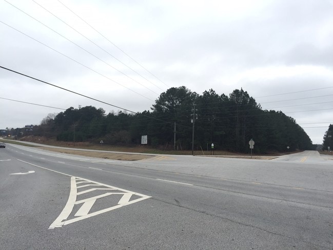
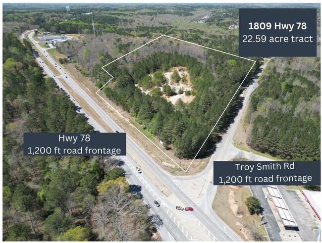
1809 Highway 78 Nw
Atlanta-Sandy Springs-Roswell, GA
22.59AC
C075000000130000
WALTON
Commercialacreage
Georgia
B2
25
B and X Area of moderate flood hazard, usually the area between the limits of the 100-year and 500-year floods.
22.59 AC
2025
Walton County
2025
Atlanta
110503
NEARBY LISTINGS FOR SALE OR LEASE
DEMOGRAPHICS near 1809 Highway 78 Nw
1 mile
3 mile
5 mile
2025 Total Population
1,563
11,839
42,231
2030 Population
1,751
13,219
47,118
Pop Growth 2025-2030
+ 12.03%
+ 11.66%
+ 11.57%
Average Age
41
41
40
2025 Total Households
538
4,150
15,217
HH Growth 2025-2030
+ 12.27%
+ 11.76%
+ 11.67%
Median Household Inc
$97,688
$90,801
$69,264
Avg Household Size
2.90
2.80
2.70
2025 Avg HH Vehicles
2.00
2.00
2.00
Median Home Value
$339,606
$353,012
$344,909
Median Year Built
2004
2001
1995
Nearby Places
Map Layers
Map Styles
 Street
 Aerial
Layers
 Traffic
 Biking
Places
Listings with unknown addresses are not visible on the map
- Restaurants
- Banks
- Shops
- Fitness
- Groceries
SALE & LEASE HISTORY
LISTING DATE
SALE/LEASE

Sep 24, 2016
For Sale
Jan 29, 2024
For Sale
Dec 30, 2021
For Sale
Aug 15, 2017
For Sale
Nearby Properties
Address
Land Use
TOTAL SIZE
Lot Size
Zoning
Address
Land Use
TOTAL SIZE
Lot Size
Zoning
117,471 SF
65.68 AC
B3
Address
Land Use
TOTAL SIZE
Lot Size
Zoning
113,162 SF
26.22 AC
PCD
Address
Land Use
TOTAL SIZE
Lot Size
Zoning
35,900 SF
44.30 AC
B3
Address
Land Use
TOTAL SIZE
Lot Size
Zoning
188,663 SF
25.40 AC
B3
Address
Land Use
TOTAL SIZE
Lot Size
Zoning
235.08 AC
B3 R1
Address
Land Use
TOTAL SIZE
Lot Size
Zoning
96,107 SF
58.49 AC
R1
Address
Land Use
TOTAL SIZE
Lot Size
Zoning
72,434 SF
14.12 AC
B3
Address
Land Use
TOTAL SIZE
Lot Size
Zoning
29,161 SF
42.44 AC
B2 R1 R2
Address
Land Use
TOTAL SIZE
Lot Size
Zoning
96,129 SF
32.74 AC
A1
Address
Land Use
TOTAL SIZE
Lot Size
Zoning
78,644 SF
9.90 AC
B3
Address
Land Use
TOTAL SIZE
Lot Size
Zoning
39,385 SF
38.48 AC
B3
Address
Land Use
TOTAL SIZE
Lot Size
Zoning
104,716 SF
11.70 AC
B3
Address
Land Use
TOTAL SIZE
Lot Size
Zoning
45,428 SF
8.11 AC
B3
Address
Land Use
TOTAL SIZE
Lot Size
Zoning
3,321 SF
9.58 AC
M1
Address
Land Use
TOTAL SIZE
Lot Size
Zoning
12,240 SF
7.16 AC
B3
Address
Land Use
TOTAL SIZE
Lot Size
Zoning
15,522 SF
2.05 AC
B3
Address
Land Use
TOTAL SIZE
Lot Size
Zoning
6.60 AC
PCD
Address
Land Use
TOTAL SIZE
Lot Size
Zoning
199.96 AC
R1
Address
Land Use
TOTAL SIZE
Lot Size
Zoning
105.57 AC
B3 PCD
Address
Land Use
TOTAL SIZE
Lot Size
Zoning
31,618 SF
4.22 AC
B3
Address
Land Use
TOTAL SIZE
Lot Size
Zoning
3.83 AC
PCD
Address
Land Use
TOTAL SIZE
Lot Size
Zoning
10,145 SF
8.41 AC
B3
Address
Land Use
TOTAL SIZE
Lot Size
Zoning
18,200 SF
4.55 AC
B3
Address
Land Use
TOTAL SIZE
Lot Size
Zoning
8,640 SF
53 AC
A1
Address
Land Use
TOTAL SIZE
Lot Size
Zoning
50,968 SF
5.57 AC
B3
Address
Land Use
TOTAL SIZE
Lot Size
Zoning
11.59 AC
PCD
Address
Land Use
TOTAL SIZE
Lot Size
Zoning
10,651 SF
11.74 AC
M1
Address
Land Use
TOTAL SIZE
Lot Size
Zoning
25,340 SF
7.59 AC
B1
Address
Land Use
TOTAL SIZE
Lot Size
Zoning
12,000 SF
3 AC
B2
Address
Land Use
TOTAL SIZE
Lot Size
Zoning
21,600 SF
7.24 AC
B3
The World's #1 Commercial Real Estate Marketplace
Connect with us
© 2026 CoStar Group
The information above has been obtained from sources believed reliable. While we do not doubt its accuracy we have not verified it and make no guarantee, warranty or representation about it. It is your responsibility to independently confirm its accuracy and completeness. Any projections, opinions, assumptions, or estimates used are for example only and do not represent the current or future performance of the property. The value of this transaction to you depends on tax and other factors which should be evaluated by your tax, financial, and legal advisors. You and your advisors should conduct a careful, independent investigation of the property to determine to your satisfaction the suitability of the property for your needs.