Property Record
1809 Las Posas Rd, Camarillo, CA 93010
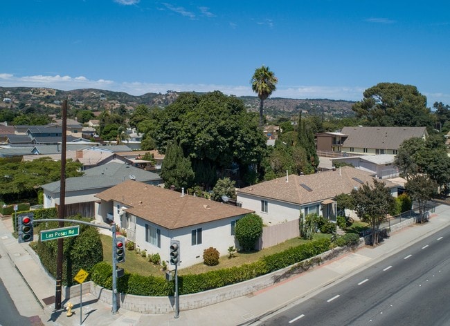

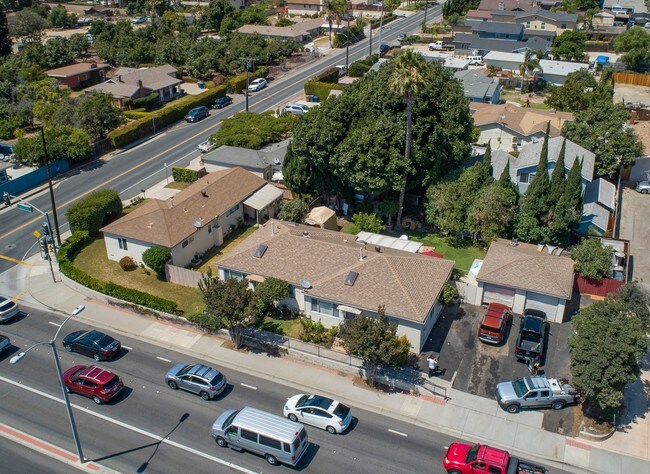
Property Detail
1809 Las Posas Rd
150-0-060-425
PR APN 1500060195
Multifamilydwelling
Ventura
R1-1
California
B and X Area of moderate flood hazard, usually the area between the limits of the 100-year and 500-year floods.
0.26 AC
2024
Camarillo
2025
Los Angeles
005203
Oxnard-Thousand Oaks-Ventura, CA
2,592 SF
NEARBY LISTINGS FOR SALE OR LEASE
DEMOGRAPHICS near 1809 Las Posas Rd
1 mile
3 mile
5 mile
2025 Total Population
16,993
65,305
83,006
2030 Population
16,749
64,992
82,613
Pop Growth 2025-2030
(1.44%)
(0.48%)
(0.47%)
Average Age
43
42
43
2025 Total Households
5,969
23,654
30,383
HH Growth 2025-2030
(1.63%)
(0.65%)
(0.58%)
Median Household Inc
$120,552
$117,233
$116,206
Avg Household Size
2.80
2.70
2.60
2025 Avg HH Vehicles
2.00
2.00
2.00
Median Home Value
$797,928
$827,279
$821,897
Median Year Built
1970
1979
1980
Nearby Places
Map Layers
Map Styles
 Street
 Aerial
Layers
 Traffic
 Biking
Places
Listings with unknown addresses are not visible on the map
- Restaurants
- Banks
- Shops
- Fitness
- Groceries
PUBLIC TRANSPORTATION
COMMUTER RAIL
Camarillo (Ventura County Line - Southern California Regional Rail Authority (Metrolink))
Drive
Walk
Distance
Camarillo (Ventura County Line - Southern California Regional Rail Authority (Metrolink))
5 min
2.5 mi
Freight Ports
The Port of Hueneme
Drive
Walk
Distance
The Port of Hueneme
21 min
12.2 mi
SALE & LEASE HISTORY
LISTING DATE
SALE/LEASE

Aug 28, 2019
For Sale
Nearby Properties
Address
Land Use
TOTAL SIZE
Lot Size
Zoning
Address
Land Use
TOTAL SIZE
Lot Size
Zoning
15.13 AC
Address
Land Use
TOTAL SIZE
Lot Size
Zoning
9.66 AC
PO
Address
Land Use
TOTAL SIZE
Lot Size
Zoning
19,288 SF
24.55 AC
CPD
Address
Land Use
TOTAL SIZE
Lot Size
Zoning
10.59 AC
Address
Land Use
TOTAL SIZE
Lot Size
Zoning
72,165 SF
24.05 AC
L-M
Address
Land Use
TOTAL SIZE
Lot Size
Zoning
33,261 SF
36.25 AC
Address
Land Use
TOTAL SIZE
Lot Size
Zoning
67,766 SF
19.31 AC
M2
Address
Land Use
TOTAL SIZE
Lot Size
Zoning
Address
Land Use
TOTAL SIZE
Lot Size
Zoning
45,587 SF
18.30 AC
Address
Land Use
TOTAL SIZE
Lot Size
Zoning
150,320 SF
6.22 AC
Address
Land Use
TOTAL SIZE
Lot Size
Zoning
123,752 SF
5.98 AC
RPD
Address
Land Use
TOTAL SIZE
Lot Size
Zoning
3.31 AC
Address
Land Use
TOTAL SIZE
Lot Size
Zoning
191,193 SF
31.89 AC
M1
Address
Land Use
TOTAL SIZE
Lot Size
Zoning
98,344 SF
7.40 AC
RPD3
Address
Land Use
TOTAL SIZE
Lot Size
Zoning
3.12 AC
Address
Land Use
TOTAL SIZE
Lot Size
Zoning
13.99 AC
Address
Land Use
TOTAL SIZE
Lot Size
Zoning
9.76 AC
Address
Land Use
TOTAL SIZE
Lot Size
Zoning
39,607 SF
10.81 AC
LM
Address
Land Use
TOTAL SIZE
Lot Size
Zoning
19.69 AC
Address
Land Use
TOTAL SIZE
Lot Size
Zoning
84,518 SF
4.71 AC
RPD
Address
Land Use
TOTAL SIZE
Lot Size
Zoning
48,546 SF
4.01 AC
M1
Address
Land Use
TOTAL SIZE
Lot Size
Zoning
77,837 SF
6.46 AC
Address
Land Use
TOTAL SIZE
Lot Size
Zoning
60,511 SF
2.95 AC
RPD30
Address
Land Use
TOTAL SIZE
Lot Size
Zoning
2.66 AC
Address
Land Use
TOTAL SIZE
Lot Size
Zoning
66,715 SF
4.07 AC
Address
Land Use
TOTAL SIZE
Lot Size
Zoning
120,688 SF
6.44 AC
Address
Land Use
TOTAL SIZE
Lot Size
Zoning
3.08 AC
Address
Land Use
TOTAL SIZE
Lot Size
Zoning
66,716 SF
1.79 AC
Address
Land Use
TOTAL SIZE
Lot Size
Zoning
117,342 SF
7.20 AC
Address
Land Use
TOTAL SIZE
Lot Size
Zoning
1,568 SF
9.87 AC
CPD
The World's #1 Commercial Real Estate Marketplace
Connect with us
© 2026 CoStar Group
The information above has been obtained from sources believed reliable. While we do not doubt its accuracy we have not verified it and make no guarantee, warranty or representation about it. It is your responsibility to independently confirm its accuracy and completeness. Any projections, opinions, assumptions, or estimates used are for example only and do not represent the current or future performance of the property. The value of this transaction to you depends on tax and other factors which should be evaluated by your tax, financial, and legal advisors. You and your advisors should conduct a careful, independent investigation of the property to determine to your satisfaction the suitability of the property for your needs.