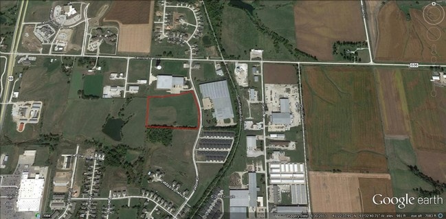
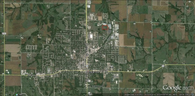
Property Record
1809 N 9Th St, Indianola, IA 50125

NEARBY LISTINGS FOR SALE OR LEASE
Property Detail
1809 N 9Th St
Des Moines-West Des Moines, IA
Hillcrest Industrial Park
48335001005
19-76-23 REPLAT HILLCREST INDUSTRIAL PARK PLAT 1 PCL B OL X
Lightindustrial
Warren
X
Iowa
19181C0168F
x
2024
4.13 AC
2025
Warren County
020702
Des Moines
97,250 SF
DEMOGRAPHICS near 1809 N 9Th St
1 Mile
3 Mile
5 Mile
2024 Total Population
4,292
17,493
19,467
2029 Population
4,668
19,150
21,301
Pop Growth 2024-2029
+ 8.76%
+ 9.47%
+ 9.42%
Average Age
38
39
40
2024 Total Households
1,636
6,517
7,279
HH Growth 2024-2029
+ 9.05%
+ 9.84%
+ 9.78%
Median Household Inc
$86,341
$71,208
$74,202
Avg Household Size
2.50
2.40
2.50
2024 Avg HH Vehicles
2.00
2.00
2.00
Median Home Value
$197,929
$191,091
$201,022
Median Year Built
1994
1978
1979
Nearby Places
Map Layers
Map Styles
 Street
 Aerial
- Restaurants
- Banks
- Shops
- Fitness
- Groceries
PUBLIC TRANSPORTATION
AIRPORT
Des Moines International
DRIVE
WALK
Distance
Des Moines International
29 min
16.5 mi
Freight Ports
Port Milwaukee
DRIVE
WALK
Distance
Port Milwaukee
434 min
387.7 mi
SALE & LEASE HISTORY
LISTING DATE
SALE/LEASE

Sep 24, 2016
For Sale
Nearby Properties
Address
Land Use
TOTAL SIZE
Lot Size
Zoning
Address
Land Use
TOTAL SIZE
Lot Size
Zoning
89,830 SF
2.24 AC
Address
Land Use
TOTAL SIZE
Lot Size
Zoning
272,571 SF
12.21 AC
Address
Land Use
TOTAL SIZE
Lot Size
Zoning
182,075 SF
25.22 AC
Address
Land Use
TOTAL SIZE
Lot Size
Zoning
250,839 SF
31.06 AC
Address
Land Use
TOTAL SIZE
Lot Size
Zoning
61,917 SF
6.63 AC
Address
Land Use
TOTAL SIZE
Lot Size
Zoning
194,432 SF
22.83 AC
Address
Land Use
TOTAL SIZE
Lot Size
Zoning
121,506 SF
6.50 AC
Address
Land Use
TOTAL SIZE
Lot Size
Zoning
63,973 SF
41.13 AC
Address
Land Use
TOTAL SIZE
Lot Size
Zoning
130,684 SF
8.92 AC
Address
Land Use
TOTAL SIZE
Lot Size
Zoning
79,067 SF
19.49 AC
Address
Land Use
TOTAL SIZE
Lot Size
Zoning
79,964 SF
14.52 AC
Address
Land Use
TOTAL SIZE
Lot Size
Zoning
268,856 SF
13 AC
Address
Land Use
TOTAL SIZE
Lot Size
Zoning
79,692 SF
1.65 AC
Address
Land Use
TOTAL SIZE
Lot Size
Zoning
67,834 SF
6 AC
Address
Land Use
TOTAL SIZE
Lot Size
Zoning
60,561 SF
6.98 AC
Address
Land Use
TOTAL SIZE
Lot Size
Zoning
98,180 SF
11.28 AC
Address
Land Use
TOTAL SIZE
Lot Size
Zoning
59,993 SF
5.84 AC
Address
Land Use
TOTAL SIZE
Lot Size
Zoning
70,460 SF
10.59 AC
Address
Land Use
TOTAL SIZE
Lot Size
Zoning
22,455 SF
3.26 AC
Address
Land Use
TOTAL SIZE
Lot Size
Zoning
60,068 SF
6.50 AC
Address
Land Use
TOTAL SIZE
Lot Size
Zoning
74,844 SF
4.17 AC
Address
Land Use
TOTAL SIZE
Lot Size
Zoning
45,724 SF
2.38 AC
Address
Land Use
TOTAL SIZE
Lot Size
Zoning
39,767 SF
2.24 AC
Address
Land Use
TOTAL SIZE
Lot Size
Zoning
18,214 SF
40.13 AC
Address
Land Use
TOTAL SIZE
Lot Size
Zoning
14,976 SF
2.38 AC
Address
Land Use
TOTAL SIZE
Lot Size
Zoning
203,120 SF
19.08 AC
Address
Land Use
TOTAL SIZE
Lot Size
Zoning
17,924 SF
1.40 AC
Address
Land Use
TOTAL SIZE
Lot Size
Zoning
112,754 SF
11.70 AC
Address
Land Use
TOTAL SIZE
Lot Size
Zoning
61,997 SF
8.42 AC
The World's #1 Commercial Real Estate Marketplace
Connect with us
© 2026 CoStar Group
The information above has been obtained from sources believed reliable. While we do not doubt its accuracy we have not verified it and make no guarantee, warranty or representation about it. It is your responsibility to independently confirm its accuracy and completeness. Any projections, opinions, assumptions, or estimates used are for example only and do not represent the current or future performance of the property. The value of this transaction to you depends on tax and other factors which should be evaluated by your tax, financial, and legal advisors. You and your advisors should conduct a careful, independent investigation of the property to determine to your satisfaction the suitability of the property for your needs.