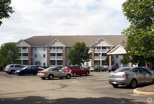
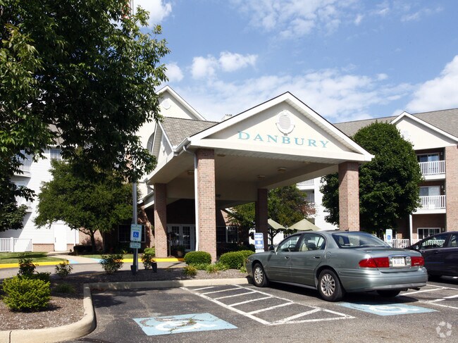
Property Record
181 Applegrove St Ne, North Canton, OH 44720

NEARBY LISTINGS FOR SALE OR LEASE
-
-
View all North Canton listings for sale on LoopNet.com
Property Detail
181 Applegrove St Ne
Canton-Massillon, OH
OL 432 - 3.84A
10016601
Stark
Apartment
Ohio
0
3.84 AC
2025
North Canton
712114
Cleveland
105,550 SF
DEMOGRAPHICS near 181 Applegrove St Ne
1 Mile
3 Mile
5 Mile
2024 Total Population
8,964
39,841
102,088
2029 Population
8,935
39,514
101,188
Pop Growth 2024-2029
(0.32%)
(0.82%)
(0.88%)
Average Age
43
43
43
2024 Total Households
4,239
16,807
43,522
HH Growth 2024-2029
(0.40%)
(0.84%)
(0.87%)
Median Household Inc
$66,285
$74,233
$73,125
Avg Household Size
2.10
2.30
2.30
2024 Avg HH Vehicles
2.00
2.00
2.00
Median Home Value
$212,958
$213,516
$204,650
Median Year Built
1982
1977
1974
Nearby Places
Map Layers
Map Styles
 Street
 Aerial
- Restaurants
- Banks
- Shops
- Fitness
- Groceries
PUBLIC TRANSPORTATION
AIRPORT
Akron-Canton Regional
DRIVE
WALK
Distance
Akron-Canton Regional
8 min
3.1 mi
Freight Ports
Port of Toledo
DRIVE
WALK
Distance
Port of Toledo
180 min
151.1 mi
Nearby Properties
Address
Land Use
TOTAL SIZE
Lot Size
Zoning
Address
Land Use
TOTAL SIZE
Lot Size
Zoning
730,347 SF
55.42 AC
Address
Land Use
TOTAL SIZE
Lot Size
Zoning
223,734 SF
1,140.33 AC
Address
Land Use
TOTAL SIZE
Lot Size
Zoning
234,168 SF
22.77 AC
Address
Land Use
TOTAL SIZE
Lot Size
Zoning
475,122 SF
81.74 AC
Address
Land Use
TOTAL SIZE
Lot Size
Zoning
494,965 SF
15.48 AC
Address
Land Use
TOTAL SIZE
Lot Size
Zoning
390,841 SF
19 AC
Address
Land Use
TOTAL SIZE
Lot Size
Zoning
103,786 SF
8.77 AC
Address
Land Use
TOTAL SIZE
Lot Size
Zoning
367,640 SF
35.46 AC
Address
Land Use
TOTAL SIZE
Lot Size
Zoning
296,562 SF
36.07 AC
Address
Land Use
TOTAL SIZE
Lot Size
Zoning
356,083 SF
32.10 AC
Address
Land Use
TOTAL SIZE
Lot Size
Zoning
234,168 SF
22.17 AC
Address
Land Use
TOTAL SIZE
Lot Size
Zoning
415,636 SF
91.33 AC
Address
Land Use
TOTAL SIZE
Lot Size
Zoning
1,247.97 AC
Address
Land Use
TOTAL SIZE
Lot Size
Zoning
150,620 SF
18.25 AC
Address
Land Use
TOTAL SIZE
Lot Size
Zoning
140,060 SF
27.57 AC
Address
Land Use
TOTAL SIZE
Lot Size
Zoning
106,867 SF
13.43 AC
Address
Land Use
TOTAL SIZE
Lot Size
Zoning
294,409 SF
18.85 AC
Address
Land Use
TOTAL SIZE
Lot Size
Zoning
103,786 SF
8.51 AC
Address
Land Use
TOTAL SIZE
Lot Size
Zoning
171,663 SF
16.77 AC
Address
Land Use
TOTAL SIZE
Lot Size
Zoning
Address
Land Use
TOTAL SIZE
Lot Size
Zoning
218,864 SF
11.84 AC
Address
Land Use
TOTAL SIZE
Lot Size
Zoning
151,342 SF
14.49 AC
Address
Land Use
TOTAL SIZE
Lot Size
Zoning
160,650 SF
17.26 AC
Address
Land Use
TOTAL SIZE
Lot Size
Zoning
155,328 SF
22.08 AC
Address
Land Use
TOTAL SIZE
Lot Size
Zoning
255,406 SF
25.19 AC
Address
Land Use
TOTAL SIZE
Lot Size
Zoning
80,416 SF
81.53 AC
Address
Land Use
TOTAL SIZE
Lot Size
Zoning
50,062 SF
8.51 AC
Address
Land Use
TOTAL SIZE
Lot Size
Zoning
106,416 SF
18.99 AC
Address
Land Use
TOTAL SIZE
Lot Size
Zoning
93,932 SF
11.31 AC
Address
Land Use
TOTAL SIZE
Lot Size
Zoning
53,687 SF
14.94 AC
The World's #1 Commercial Real Estate Marketplace
Connect with us
© 2025 CoStar Group
The information above has been obtained from sources believed reliable. While we do not doubt its accuracy we have not verified it and make no guarantee, warranty or representation about it. It is your responsibility to independently confirm its accuracy and completeness. Any projections, opinions, assumptions, or estimates used are for example only and do not represent the current or future performance of the property. The value of this transaction to you depends on tax and other factors which should be evaluated by your tax, financial, and legal advisors. You and your advisors should conduct a careful, independent investigation of the property to determine to your satisfaction the suitability of the property for your needs.