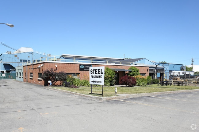
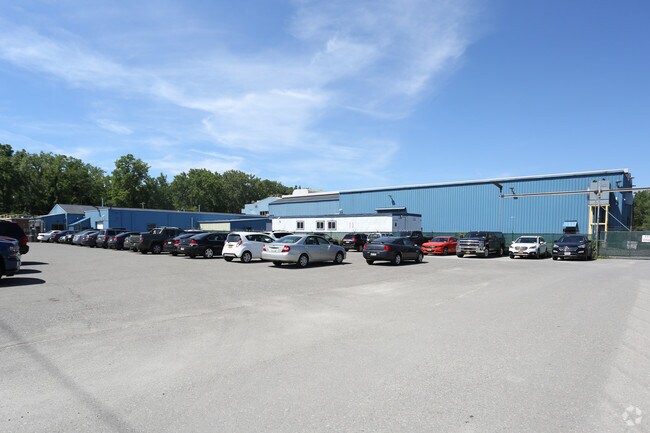
Property Record
181 Mckee Rd, Rochester, NY 14611
NEARBY LISTINGS FOR SALE OR LEASE
Property Detail
181 Mckee Rd
261400-119-360-0001-003-000-0000
0087.02 502 24 00065 4315291777915800
Manufacturinglight
Monroe
X
New York
36055C0193G
4.000
2025
5.69 AC
2024
Greater Rochester
006300
Rochester
22,761 SF
Rochester, NY
DEMOGRAPHICS near 181 Mckee Rd
1 Mile
3 Mile
5 Mile
2024 Total Population
6,392
97,447
266,849
2029 Population
6,265
95,717
262,692
Pop Growth 2024-2029
(1.99%)
(1.78%)
(1.56%)
Average Age
40
38
38
2024 Total Households
2,696
39,683
114,382
HH Growth 2024-2029
(2.11%)
(1.82%)
(1.60%)
Median Household Inc
$43,142
$45,024
$49,836
Avg Household Size
2.30
2.30
2.20
2024 Avg HH Vehicles
1.00
1.00
1.00
Median Home Value
$86,073
$108,946
$134,386
Median Year Built
1949
1948
1954
Nearby Places
- Restaurants
- Banks
- Shops
- Fitness
- Groceries
PUBLIC TRANSPORTATION
COMMUTER RAIL
Rochester (Empire Service - VIA Rail, Lake Shore Limited - VIA Rail, Maple Leaf - VIA Rail, Toronto - New York - VIA Rail)
DRIVE
WALK
Distance
Rochester (Empire Service - VIA Rail, Lake Shore Limited - VIA Rail, Maple Leaf - VIA Rail, Toronto - New York - VIA Rail)
8 min
4.1 mi
AIRPORT
Frederick Douglass/Greater Rochester International
DRIVE
WALK
Distance
Frederick Douglass/Greater Rochester International
10 min
4.9 mi
Freight Ports
Albany, NY Port
DRIVE
WALK
Distance
Albany, NY Port
273 min
229.9 mi
Nearby Properties
Address
Land Use
TOTAL SIZE
Lot Size
Zoning
Address
Land Use
TOTAL SIZE
Lot Size
Zoning
0.47 AC
Address
Land Use
TOTAL SIZE
Lot Size
Zoning
173,649 SF
85.98 AC
Address
Land Use
TOTAL SIZE
Lot Size
Zoning
628,572 SF
134.14 AC
06 - INDUS
Address
Land Use
TOTAL SIZE
Lot Size
Zoning
200,000 SF
764.91 AC
Address
Land Use
TOTAL SIZE
Lot Size
Zoning
181,500 SF
57.85 AC
Address
Land Use
TOTAL SIZE
Lot Size
Zoning
64,041 SF
42.66 AC
Address
Land Use
TOTAL SIZE
Lot Size
Zoning
41,376 SF
59.90 AC
06 - INDUS
Address
Land Use
TOTAL SIZE
Lot Size
Zoning
11,408 SF
98.28 AC
02 - SINGL
Address
Land Use
TOTAL SIZE
Lot Size
Zoning
13.10 AC
Address
Land Use
TOTAL SIZE
Lot Size
Zoning
373,200 SF
5.42 AC
Address
Land Use
TOTAL SIZE
Lot Size
Zoning
178,321 SF
3.10 AC
Address
Land Use
TOTAL SIZE
Lot Size
Zoning
0.01 AC
Address
Land Use
TOTAL SIZE
Lot Size
Zoning
7,200 SF
12.35 AC
Address
Land Use
TOTAL SIZE
Lot Size
Zoning
0.01 AC
Address
Land Use
TOTAL SIZE
Lot Size
Zoning
0.65 AC
Address
Land Use
TOTAL SIZE
Lot Size
Zoning
261,960 SF
3.73 AC
Address
Land Use
TOTAL SIZE
Lot Size
Zoning
1.06 AC
Address
Land Use
TOTAL SIZE
Lot Size
Zoning
14,219 SF
2.34 AC
Address
Land Use
TOTAL SIZE
Lot Size
Zoning
540,000 SF
39.70 AC
06 - INDUS
Address
Land Use
TOTAL SIZE
Lot Size
Zoning
2.63 AC
Address
Land Use
TOTAL SIZE
Lot Size
Zoning
0.01 AC
Address
Land Use
TOTAL SIZE
Lot Size
Zoning
274,700 SF
24.79 AC
Address
Land Use
TOTAL SIZE
Lot Size
Zoning
33,902 SF
5.57 AC
Address
Land Use
TOTAL SIZE
Lot Size
Zoning
1,440 SF
5.40 AC
02 - SINGL
Address
Land Use
TOTAL SIZE
Lot Size
Zoning
195,775 SF
3.90 AC
Address
Land Use
TOTAL SIZE
Lot Size
Zoning
3,281 SF
17.99 AC
Address
Land Use
TOTAL SIZE
Lot Size
Zoning
201,774 SF
17.17 AC
05 - COMME
Address
Land Use
TOTAL SIZE
Lot Size
Zoning
119,777 SF
14.38 AC
06 - INDUS
Address
Land Use
TOTAL SIZE
Lot Size
Zoning
391,478 SF
29.27 AC
Address
Land Use
TOTAL SIZE
Lot Size
Zoning
118,580 SF
6.01 AC
The World's #1 Commercial Real Estate Marketplace
Connect with us
© 2025 CoStar Group
The information above has been obtained from sources believed reliable. While we do not doubt its accuracy we have not verified it and make no guarantee, warranty or representation about it. It is your responsibility to independently confirm its accuracy and completeness. Any projections, opinions, assumptions, or estimates used are for example only and do not represent the current or future performance of the property. The value of this transaction to you depends on tax and other factors which should be evaluated by your tax, financial, and legal advisors. You and your advisors should conduct a careful, independent investigation of the property to determine to your satisfaction the suitability of the property for your needs.