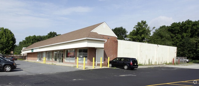
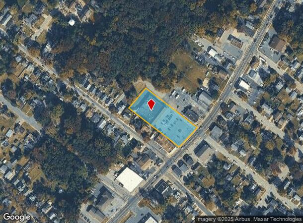
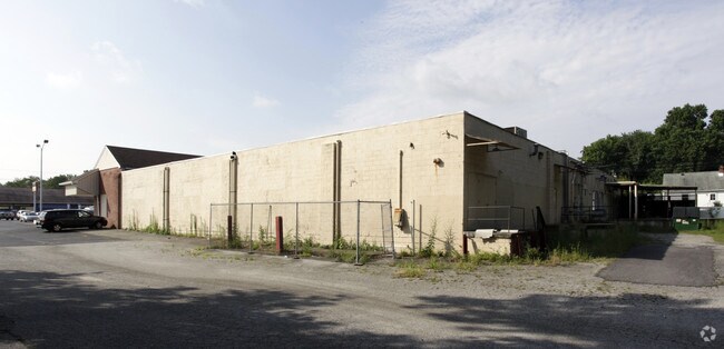
Property Record
181 N Broadway Way, Pennsville, NJ 08070
NEARBY LISTINGS FOR SALE OR LEASE
Property Detail
181 N Broadway Way
09-01605-0000-00012
Central Park
Medicalbuilding
Salem
AE
New Jersey
34033C0042C
12
2024
1.49 AC
2025
Salem County
021700
Philadelphia
19,564 SF
Philadelphia-Camden-Wilmington, PA-NJ-DE-MD
DEMOGRAPHICS near 181 N Broadway Way
1 Mile
3 Mile
5 Mile
2024 Total Population
4,051
17,227
55,886
2029 Population
4,049
17,419
56,647
Pop Growth 2024-2029
(0.05%)
+ 1.11%
+ 1.36%
Average Age
43
43
41
2024 Total Households
1,686
7,009
21,546
HH Growth 2024-2029
(0.06%)
+ 1.06%
+ 1.29%
Median Household Inc
$77,750
$70,775
$63,531
Avg Household Size
2.40
2.40
2.50
2024 Avg HH Vehicles
2.00
2.00
2.00
Median Home Value
$156,535
$172,207
$175,588
Median Year Built
1952
1959
1959
Nearby Places
Map Layers
Map Styles
 Street
 Aerial
- Restaurants
- Banks
- Shops
- Fitness
- Groceries
PUBLIC TRANSPORTATION
COMMUTER RAIL
Wilmington (R2 - Southeastern Pennsylvania Transportation Authority Regional Rail (SEPTA Regional Rail))
DRIVE
WALK
Distance
Wilmington (R2 - Southeastern Pennsylvania Transportation Authority Regional Rail (SEPTA Regional Rail))
16 min
8.3 mi
AIRPORT
Philadelphia International
DRIVE
WALK
Distance
Philadelphia International
39 min
26.5 mi
Freight Ports
Port of Wilmington, RI
DRIVE
WALK
Distance
Port of Wilmington, RI
16 min
8.2 mi
Nearby Properties
Address
Land Use
TOTAL SIZE
Lot Size
Zoning
Address
Land Use
TOTAL SIZE
Lot Size
Zoning
412.70 AC
06
Address
Land Use
TOTAL SIZE
Lot Size
Zoning
26.64 AC
GI
Address
Land Use
TOTAL SIZE
Lot Size
Zoning
29,344 SF
32.65 AC
02/0
Address
Land Use
TOTAL SIZE
Lot Size
Zoning
192 SF
113.56 AC
05
Address
Land Use
TOTAL SIZE
Lot Size
Zoning
1,133.55 AC
GI
Address
Land Use
TOTAL SIZE
Lot Size
Zoning
2,016 SF
1.44 AC
02
Address
Land Use
TOTAL SIZE
Lot Size
Zoning
Address
Land Use
TOTAL SIZE
Lot Size
Zoning
31.77 AC
GC
Address
Land Use
TOTAL SIZE
Lot Size
Zoning
100,128 SF
30.05 AC
04/0
Address
Land Use
TOTAL SIZE
Lot Size
Zoning
450 SF
225 AC
06
Address
Land Use
TOTAL SIZE
Lot Size
Zoning
14.20 AC
04/0
Address
Land Use
TOTAL SIZE
Lot Size
Zoning
61,928 SF
128.88 AC
HI
Address
Land Use
TOTAL SIZE
Lot Size
Zoning
421,754 SF
47.58 AC
21I
Address
Land Use
TOTAL SIZE
Lot Size
Zoning
17.79 AC
04
Address
Land Use
TOTAL SIZE
Lot Size
Zoning
213,565 SF
11.73 AC
21I
Address
Land Use
TOTAL SIZE
Lot Size
Zoning
12,404 SF
5.58 AC
04
Address
Land Use
TOTAL SIZE
Lot Size
Zoning
115,880 SF
20.85 AC
21IOP
Address
Land Use
TOTAL SIZE
Lot Size
Zoning
1,260 SF
3.39 AC
02
Address
Land Use
TOTAL SIZE
Lot Size
Zoning
9,636 SF
10.97 AC
GC
Address
Land Use
TOTAL SIZE
Lot Size
Zoning
79,778 SF
8.83 AC
NC6.5
Address
Land Use
TOTAL SIZE
Lot Size
Zoning
8.82 AC
04
Address
Land Use
TOTAL SIZE
Lot Size
Zoning
40,294 SF
10.36 AC
02
Address
Land Use
TOTAL SIZE
Lot Size
Zoning
234,000 SF
15.52 AC
21I
Address
Land Use
TOTAL SIZE
Lot Size
Zoning
225,128 SF
9.47 AC
21I
Address
Land Use
TOTAL SIZE
Lot Size
Zoning
76,331 SF
52.52 AC
HI
Address
Land Use
TOTAL SIZE
Lot Size
Zoning
139.82 AC
LI
Address
Land Use
TOTAL SIZE
Lot Size
Zoning
2,052 SF
16.59 AC
04
Address
Land Use
TOTAL SIZE
Lot Size
Zoning
48,944 SF
8.64 AC
21I
Address
Land Use
TOTAL SIZE
Lot Size
Zoning
177,048 SF
13.88 AC
21IOP
Address
Land Use
TOTAL SIZE
Lot Size
Zoning
61,336 SF
8.85 AC
HI
The World's #1 Commercial Real Estate Marketplace
Connect with us
© 2025 CoStar Group
The information above has been obtained from sources believed reliable. While we do not doubt its accuracy we have not verified it and make no guarantee, warranty or representation about it. It is your responsibility to independently confirm its accuracy and completeness. Any projections, opinions, assumptions, or estimates used are for example only and do not represent the current or future performance of the property. The value of this transaction to you depends on tax and other factors which should be evaluated by your tax, financial, and legal advisors. You and your advisors should conduct a careful, independent investigation of the property to determine to your satisfaction the suitability of the property for your needs.