Property Record
181 S Franklin St, Holbrook, MA 02343
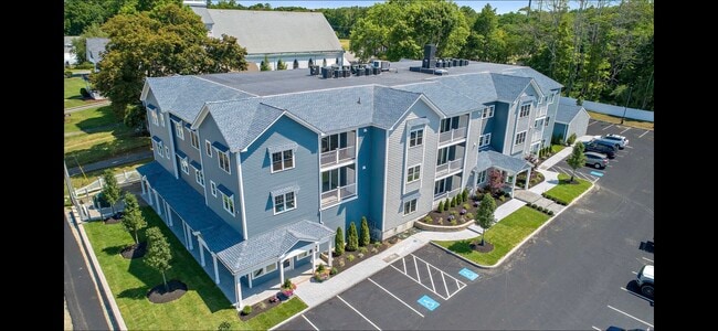

This Property Is For Sale
NEARBY LISTINGS FOR SALE OR LEASE
Property Detail
181 S Franklin St
27-037-207
Norfolk
Condominium
Massachusetts
X
Route 24
25021C0219F
Boston
1,208 SF
Boston-Cambridge-Newton, MA-NH
DEMOGRAPHICS near 181 S Franklin St
1 Mile
3 Mile
5 Mile
2024 Total Population
7,202
58,697
198,951
2029 Population
7,137
58,381
197,382
Pop Growth 2024-2029
(0.90%)
(0.54%)
(0.79%)
Average Age
41
42
41
2024 Total Households
2,700
21,384
73,830
HH Growth 2024-2029
(0.93%)
(0.58%)
(0.84%)
Median Household Inc
$91,675
$102,392
$90,952
Avg Household Size
2.60
2.70
2.60
2024 Avg HH Vehicles
2.00
2.00
2.00
Median Home Value
$368,763
$440,454
$444,840
Median Year Built
1954
1961
1963
Nearby Places
- Restaurants
- Banks
- Shops
- Fitness
- Groceries
PUBLIC TRANSPORTATION
COMMUTER RAIL
Holbrook/Randolph (Middleborough/Lakeville Line - Massachusetts Bay Transportation Authority Commuter Rail (Purple Line))
DRIVE
WALK
Distance
Holbrook/Randolph (Middleborough/Lakeville Line - Massachusetts Bay Transportation Authority Commuter Rail (Purple Line))
3 min
1.5 mi
South Weymouth (Kingston/Plymouth Line - Massachusetts Bay Transportation Authority Commuter Rail (Purple Line))
DRIVE
WALK
Distance
South Weymouth (Kingston/Plymouth Line - Massachusetts Bay Transportation Authority Commuter Rail (Purple Line))
9 min
4.8 mi
AIRPORT
General Edward Lawrence Logan International
DRIVE
WALK
Distance
General Edward Lawrence Logan International
32 min
19.1 mi
Freight Ports
Port of Boston
DRIVE
WALK
Distance
Port of Boston
29 min
16.9 mi
Nearby Properties
Address
Land Use
TOTAL SIZE
Lot Size
Zoning
Address
Land Use
TOTAL SIZE
Lot Size
Zoning
40,396 SF
5.56 AC
100
Address
Land Use
TOTAL SIZE
Lot Size
Zoning
235,150 SF
36.67 AC
R1
Address
Land Use
TOTAL SIZE
Lot Size
Zoning
13.08 AC
HB
Address
Land Use
TOTAL SIZE
Lot Size
Zoning
168,801 SF
2.75 AC
100
Address
Land Use
TOTAL SIZE
Lot Size
Zoning
170,035 SF
1.64 AC
100
Address
Land Use
TOTAL SIZE
Lot Size
Zoning
167,076 SF
16 AC
A
Address
Land Use
TOTAL SIZE
Lot Size
Zoning
10.10 AC
CSBD
Address
Land Use
TOTAL SIZE
Lot Size
Zoning
80,226 SF
6.60 AC
RES
Address
Land Use
TOTAL SIZE
Lot Size
Zoning
86,564 SF
8.45 AC
GBHD
Address
Land Use
TOTAL SIZE
Lot Size
Zoning
379,908 SF
15.14 AC
Address
Land Use
TOTAL SIZE
Lot Size
Zoning
199,072 SF
10.07 AC
HB
Address
Land Use
TOTAL SIZE
Lot Size
Zoning
76,223 SF
19.83 AC
B
Address
Land Use
TOTAL SIZE
Lot Size
Zoning
114,176 SF
11.69 AC
RH
Address
Land Use
TOTAL SIZE
Lot Size
Zoning
34.28 AC
85
Address
Land Use
TOTAL SIZE
Lot Size
Zoning
34.45 AC
HB
Address
Land Use
TOTAL SIZE
Lot Size
Zoning
121,424 SF
11.11 AC
HB
Address
Land Use
TOTAL SIZE
Lot Size
Zoning
10.83 AC
Address
Land Use
TOTAL SIZE
Lot Size
Zoning
190,000 SF
11.42 AC
Address
Land Use
TOTAL SIZE
Lot Size
Zoning
1.95 AC
A
Address
Land Use
TOTAL SIZE
Lot Size
Zoning
3.82 AC
A
Address
Land Use
TOTAL SIZE
Lot Size
Zoning
1,452 SF
28.90 AC
R1C
Address
Land Use
TOTAL SIZE
Lot Size
Zoning
119,130 SF
14.29 AC
HB
Address
Land Use
TOTAL SIZE
Lot Size
Zoning
89,764 SF
6.77 AC
Address
Land Use
TOTAL SIZE
Lot Size
Zoning
137,765 SF
12.40 AC
Address
Land Use
TOTAL SIZE
Lot Size
Zoning
99,432 SF
10 AC
HBD
Address
Land Use
TOTAL SIZE
Lot Size
Zoning
12.17 AC
R4
Address
Land Use
TOTAL SIZE
Lot Size
Zoning
272,764 SF
13.98 AC
HBD
Address
Land Use
TOTAL SIZE
Lot Size
Zoning
8.15 AC
HB
Address
Land Use
TOTAL SIZE
Lot Size
Zoning
100,000 SF
8.60 AC
Address
Land Use
TOTAL SIZE
Lot Size
Zoning
150,995 SF
10.13 AC
The World's #1 Commercial Real Estate Marketplace
Connect with us
© 2025 CoStar Group
The information above has been obtained from sources believed reliable. While we do not doubt its accuracy we have not verified it and make no guarantee, warranty or representation about it. It is your responsibility to independently confirm its accuracy and completeness. Any projections, opinions, assumptions, or estimates used are for example only and do not represent the current or future performance of the property. The value of this transaction to you depends on tax and other factors which should be evaluated by your tax, financial, and legal advisors. You and your advisors should conduct a careful, independent investigation of the property to determine to your satisfaction the suitability of the property for your needs.