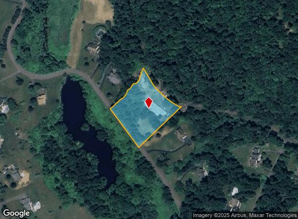
Property Record
181 State Route 37, New Fairfield, CT 06812
Current Lease Availabilities
NEARBY LISTINGS FOR SALE OR LEASE
-
-
View all New Fairfield listings for lease on LoopNet.com
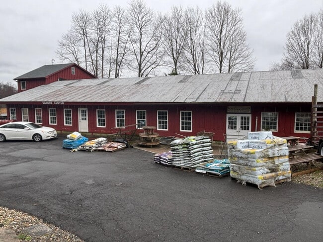
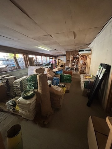
Property Detail
181 State Route 37
NFAI-000012-000001-000074
Fairfield
Commercialbuilding
Connecticut
X
74
09001C0107F
2.10 AC
2025
Danbury
2025
Westchester/So Connecticut
220100
Bridgeport-Stamford-Norwalk, CT
3,552 SF
DEMOGRAPHICS near 181 State Route 37
1 Mile
3 Mile
5 Mile
2024 Total Population
1,274
13,777
36,996
2029 Population
1,278
13,826
37,279
Pop Growth 2024-2029
+ 0.31%
+ 0.36%
+ 0.76%
Average Age
42
42
43
2024 Total Households
461
4,569
13,023
HH Growth 2024-2029
+ 0.22%
+ 0.28%
+ 0.81%
Median Household Inc
$142,187
$121,836
$119,806
Avg Household Size
2.70
2.70
2.60
2024 Avg HH Vehicles
3.00
2.00
2.00
Median Home Value
$422,400
$374,978
$399,135
Median Year Built
1974
1968
1970
Nearby Places
- Restaurants
- Banks
- Shops
- Fitness
- Groceries
PUBLIC TRANSPORTATION
COMMUTER RAIL
Patterson Station (Harlem Line - Metro-North Commuter Railroad Company (Metro-North))
DRIVE
WALK
Distance
Patterson Station (Harlem Line - Metro-North Commuter Railroad Company (Metro-North))
11 min
6.3 mi
Pawling Station (Harlem Line - Metro-North Commuter Railroad Company (Metro-North))
DRIVE
WALK
Distance
Pawling Station (Harlem Line - Metro-North Commuter Railroad Company (Metro-North))
17 min
9.5 mi
AIRPORT
New York Stewart International
DRIVE
WALK
Distance
New York Stewart International
55 min
38.4 mi
Freight Ports
Port of New Haven
DRIVE
WALK
Distance
Port of New Haven
66 min
43.6 mi
Nearby Properties
Address
Land Use
TOTAL SIZE
Lot Size
Zoning
Address
Land Use
TOTAL SIZE
Lot Size
Zoning
1,498,293 SF
361.91 AC
R4
Address
Land Use
TOTAL SIZE
Lot Size
Zoning
305,658 SF
83.46 AC
2
Address
Land Use
TOTAL SIZE
Lot Size
Zoning
79,869 SF
13.81 AC
G-12
Address
Land Use
TOTAL SIZE
Lot Size
Zoning
12,064 SF
12.10 AC
C1
Address
Land Use
TOTAL SIZE
Lot Size
Zoning
38.23 AC
2
Address
Land Use
TOTAL SIZE
Lot Size
Zoning
136,711 SF
14.20 AC
2
Address
Land Use
TOTAL SIZE
Lot Size
Zoning
178,472 SF
2.74 AC
R4
Address
Land Use
TOTAL SIZE
Lot Size
Zoning
59,640 SF
7.82 AC
C
Address
Land Use
TOTAL SIZE
Lot Size
Zoning
2,295.68 AC
Address
Land Use
TOTAL SIZE
Lot Size
Zoning
12,871 SF
277.38 AC
R4
Address
Land Use
TOTAL SIZE
Lot Size
Zoning
Address
Land Use
TOTAL SIZE
Lot Size
Zoning
Address
Land Use
TOTAL SIZE
Lot Size
Zoning
26,800 SF
5 AC
C
Address
Land Use
TOTAL SIZE
Lot Size
Zoning
Address
Land Use
TOTAL SIZE
Lot Size
Zoning
6,840 SF
127.82 AC
RPL10
Address
Land Use
TOTAL SIZE
Lot Size
Zoning
25,074 SF
5.37 AC
2
Address
Land Use
TOTAL SIZE
Lot Size
Zoning
9,992 SF
75 AC
R2
Address
Land Use
TOTAL SIZE
Lot Size
Zoning
2.41 AC
C
Address
Land Use
TOTAL SIZE
Lot Size
Zoning
Address
Land Use
TOTAL SIZE
Lot Size
Zoning
2.50 AC
C1
Address
Land Use
TOTAL SIZE
Lot Size
Zoning
604.69 AC
R4
Address
Land Use
TOTAL SIZE
Lot Size
Zoning
11,298 SF
2.29 AC
C
Address
Land Use
TOTAL SIZE
Lot Size
Zoning
19,929 SF
1.65 AC
C
Address
Land Use
TOTAL SIZE
Lot Size
Zoning
Address
Land Use
TOTAL SIZE
Lot Size
Zoning
221.76 AC
2
Address
Land Use
TOTAL SIZE
Lot Size
Zoning
2,414 SF
53.85 AC
R2
Address
Land Use
TOTAL SIZE
Lot Size
Zoning
13,961 SF
2 AC
GB
Address
Land Use
TOTAL SIZE
Lot Size
Zoning
261.39 AC
R4
Address
Land Use
TOTAL SIZE
Lot Size
Zoning
237.25 AC
R4
Address
Land Use
TOTAL SIZE
Lot Size
Zoning
12,000 SF
1.56 AC
C
The World's #1 Commercial Real Estate Marketplace
Connect with us
© 2025 CoStar Group
The information above has been obtained from sources believed reliable. While we do not doubt its accuracy we have not verified it and make no guarantee, warranty or representation about it. It is your responsibility to independently confirm its accuracy and completeness. Any projections, opinions, assumptions, or estimates used are for example only and do not represent the current or future performance of the property. The value of this transaction to you depends on tax and other factors which should be evaluated by your tax, financial, and legal advisors. You and your advisors should conduct a careful, independent investigation of the property to determine to your satisfaction the suitability of the property for your needs.