Property Record
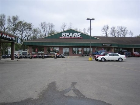
1810 6Th St, Brookings, SD 57006

Property Detail
1810 6Th St
400690010000000
BRICKWOOD PLAZA ADDITION LOT 1 134,764 SF
Commercialnec
BROOKINGS
B2
South Dakota
B and X Area of moderate flood hazard, usually the area between the limits of the 100-year and 500-year floods.
3.09 AC
2025
South Dakota Area
2026
Other Market Areas
958900
Brookings, SD
NEARBY LISTINGS FOR SALE OR LEASE
DEMOGRAPHICS near 1810 6Th St
1 mile
3 mile
5 mile
2025 Total Population
9,367
26,067
28,271
2030 Population
9,811
27,694
30,029
Pop Growth 2025-2030
+ 4.74%
+ 6.24%
+ 6.22%
Average Age
33
34
34
2025 Total Households
3,551
10,027
10,828
HH Growth 2025-2030
+ 5.32%
+ 6.87%
+ 6.84%
Median Household Inc
$54,339
$65,088
$66,690
Avg Household Size
2.10
2.20
2.30
2025 Avg HH Vehicles
2.00
2.00
2.00
Median Home Value
$247,070
$268,299
$269,586
Median Year Built
1970
1985
1986
Nearby Places
Map Layers
Map Styles
 Street
 Aerial
Layers
 Traffic
 Biking
Places
Listings with unknown addresses are not visible on the map
- Restaurants
- Banks
- Shops
- Fitness
- Groceries
Nearby Properties
Address
Land Use
TOTAL SIZE
Lot Size
Zoning
Address
Land Use
TOTAL SIZE
Lot Size
Zoning
113.12 AC
I1
Address
Land Use
TOTAL SIZE
Lot Size
Zoning
Address
Land Use
TOTAL SIZE
Lot Size
Zoning
16.79 AC
I1R
Address
Land Use
TOTAL SIZE
Lot Size
Zoning
Address
Land Use
TOTAL SIZE
Lot Size
Zoning
2,265 SF
10.30 AC
Address
Land Use
TOTAL SIZE
Lot Size
Zoning
6.60 AC
PDD
Address
Land Use
TOTAL SIZE
Lot Size
Zoning
20.65 AC
I1R
Address
Land Use
TOTAL SIZE
Lot Size
Zoning
19.83 AC
B4
Address
Land Use
TOTAL SIZE
Lot Size
Zoning
35.30 AC
I1R
Address
Land Use
TOTAL SIZE
Lot Size
Zoning
5.03 AC
Address
Land Use
TOTAL SIZE
Lot Size
Zoning
11.42 AC
B4
Address
Land Use
TOTAL SIZE
Lot Size
Zoning
1.70 AC
Address
Land Use
TOTAL SIZE
Lot Size
Zoning
14.70 AC
I1
Address
Land Use
TOTAL SIZE
Lot Size
Zoning
4.17 AC
Address
Land Use
TOTAL SIZE
Lot Size
Zoning
Address
Land Use
TOTAL SIZE
Lot Size
Zoning
16.12 AC
Address
Land Use
TOTAL SIZE
Lot Size
Zoning
39.78 AC
I2
Address
Land Use
TOTAL SIZE
Lot Size
Zoning
7.20 AC
Address
Land Use
TOTAL SIZE
Lot Size
Zoning
22.18 AC
I1R
Address
Land Use
TOTAL SIZE
Lot Size
Zoning
1.61 AC
B2
Address
Land Use
TOTAL SIZE
Lot Size
Zoning
1,208 SF
1.58 AC
R2
Address
Land Use
TOTAL SIZE
Lot Size
Zoning
2.47 AC
B3
Address
Land Use
TOTAL SIZE
Lot Size
Zoning
12.66 AC
B2
Address
Land Use
TOTAL SIZE
Lot Size
Zoning
9.14 AC
Address
Land Use
TOTAL SIZE
Lot Size
Zoning
4.78 AC
Address
Land Use
TOTAL SIZE
Lot Size
Zoning
2.33 AC
Address
Land Use
TOTAL SIZE
Lot Size
Zoning
3.28 AC
Address
Land Use
TOTAL SIZE
Lot Size
Zoning
3.10 AC
Address
Land Use
TOTAL SIZE
Lot Size
Zoning
13.65 AC
B2
Address
Land Use
TOTAL SIZE
Lot Size
Zoning
The World's #1 Commercial Real Estate Marketplace
Connect with us
© 2026 CoStar Group
The information above has been obtained from sources believed reliable. While we do not doubt its accuracy we have not verified it and make no guarantee, warranty or representation about it. It is your responsibility to independently confirm its accuracy and completeness. Any projections, opinions, assumptions, or estimates used are for example only and do not represent the current or future performance of the property. The value of this transaction to you depends on tax and other factors which should be evaluated by your tax, financial, and legal advisors. You and your advisors should conduct a careful, independent investigation of the property to determine to your satisfaction the suitability of the property for your needs.