Property Record
1810 Highway 14 E, Landrum, SC 29356

NEARBY LISTINGS FOR SALE OR LEASE
-
-
View all Landrum listings for sale on LoopNet.com
Property Detail
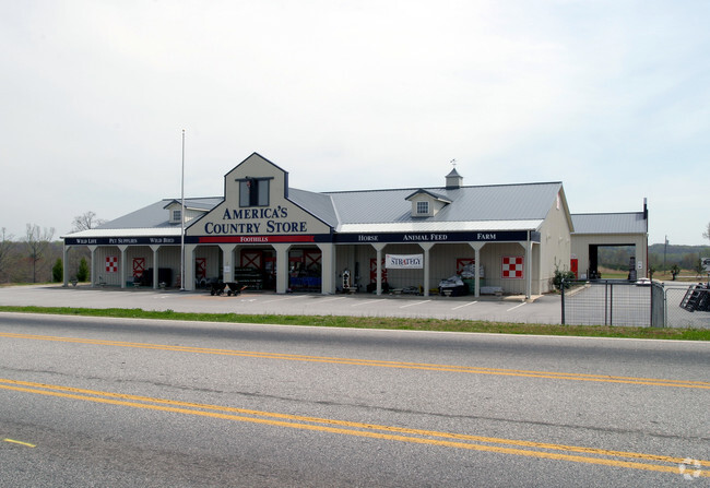
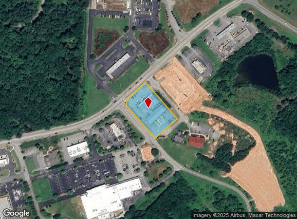
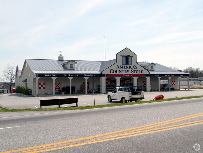
1810 Highway 14 E
1-08-00-036.03
Thomas L Simpson
Commercialnec
S SIDE SC 14 & W OF I-26 PB 151-791 PB 163-946 DB 93C-996 HWY R/W TAKEN 42.2001.9 TR 108 PB 180-984
X
Spartanburg
45083C0016D
South Carolina
2024
1.40 AC
2025
Upper Spartanburg Cty
022600
Greenville/Spartanburg
16,106 SF
Spartanburg, SC
DEMOGRAPHICS near 1810 Highway 14 E
1 mile
3 mile
5 mile
2024 Total Population
869
5,555
15,120
2029 Population
981
6,259
16,903
Pop Growth 2024-2029
+ 12.89%
+ 12.67%
+ 11.79%
Average Age
45
45
47
2024 Total Households
390
2,399
6,511
HH Growth 2024-2029
+ 13.08%
+ 12.84%
+ 11.84%
Median Household Inc
$41,704
$51,283
$54,826
Avg Household Size
2.20
2.30
2.30
2024 Avg HH Vehicles
2.00
2.00
2.00
Median Home Value
$197,320
$237,381
$264,711
Median Year Built
1971
1977
1983
Nearby Places
Map Layers
Map Styles
 Street
 Aerial
Transit
 Traffic
 Biking
Places
Listings with unknown addresses are not visible on the map
- Restaurants
- Banks
- Shops
- Fitness
- Groceries
PUBLIC TRANSPORTATION
AIRPORT
Greenville Spartanburg International
Drive
Walk
Distance
Greenville Spartanburg International
40 min
32.2 mi
Asheville Regional
Drive
Walk
Distance
Asheville Regional
40 min
32.4 mi
Nearby Properties
Address
Land Use
TOTAL SIZE
Lot Size
Zoning
Address
Land Use
TOTAL SIZE
Lot Size
Zoning
166.74 AC
RE5
Address
Land Use
TOTAL SIZE
Lot Size
Zoning
7,703 SF
190.87 AC
RE5
Address
Land Use
TOTAL SIZE
Lot Size
Zoning
332.64 AC
Address
Land Use
TOTAL SIZE
Lot Size
Zoning
9,745 SF
10.01 AC
Address
Land Use
TOTAL SIZE
Lot Size
Zoning
4,976 SF
28.42 AC
AR5
Address
Land Use
TOTAL SIZE
Lot Size
Zoning
1,978 SF
50.60 AC
AR5
Address
Land Use
TOTAL SIZE
Lot Size
Zoning
2,749 SF
48.38 AC
MX
Address
Land Use
TOTAL SIZE
Lot Size
Zoning
6,560 SF
22.83 AC
AR5
Address
Land Use
TOTAL SIZE
Lot Size
Zoning
2,290 SF
23.19 AC
RE5
Address
Land Use
TOTAL SIZE
Lot Size
Zoning
728 SF
55.77 AC
RE5
Address
Land Use
TOTAL SIZE
Lot Size
Zoning
3,102 SF
21.74 AC
RE5
Address
Land Use
TOTAL SIZE
Lot Size
Zoning
3,030 SF
14.53 AC
RE5
Address
Land Use
TOTAL SIZE
Lot Size
Zoning
686 SF
44.91 AC
RE5
Address
Land Use
TOTAL SIZE
Lot Size
Zoning
2,564 SF
285.70 AC
RE5
Address
Land Use
TOTAL SIZE
Lot Size
Zoning
3,684 SF
36.77 AC
MX
Address
Land Use
TOTAL SIZE
Lot Size
Zoning
2,143 SF
53.88 AC
AR5
Address
Land Use
TOTAL SIZE
Lot Size
Zoning
3,585 SF
7.02 AC
RE5
Address
Land Use
TOTAL SIZE
Lot Size
Zoning
2,512 SF
34.04 AC
RE5
Address
Land Use
TOTAL SIZE
Lot Size
Zoning
4,738 SF
21.48 AC
MX
Address
Land Use
TOTAL SIZE
Lot Size
Zoning
1,798 SF
26.75 AC
MX
Address
Land Use
TOTAL SIZE
Lot Size
Zoning
3,149 SF
40.74 AC
RE5
Address
Land Use
TOTAL SIZE
Lot Size
Zoning
5,606 SF
18.94 AC
AR5
Address
Land Use
TOTAL SIZE
Lot Size
Zoning
1,309 SF
18.19 AC
MX
Address
Land Use
TOTAL SIZE
Lot Size
Zoning
3,823 SF
13.47 AC
MX
Address
Land Use
TOTAL SIZE
Lot Size
Zoning
780 SF
23.37 AC
MX
Address
Land Use
TOTAL SIZE
Lot Size
Zoning
14.59 AC
RE5
Address
Land Use
TOTAL SIZE
Lot Size
Zoning
24.28 AC
RE5
Address
Land Use
TOTAL SIZE
Lot Size
Zoning
3,545 SF
23.09 AC
AR5
Address
Land Use
TOTAL SIZE
Lot Size
Zoning
41.93 AC
RE5
Address
Land Use
TOTAL SIZE
Lot Size
Zoning
3,123 SF
2.73 AC
MX
The World's #1 Commercial Real Estate Marketplace
Connect with us
© 2026 CoStar Group
The information above has been obtained from sources believed reliable. While we do not doubt its accuracy we have not verified it and make no guarantee, warranty or representation about it. It is your responsibility to independently confirm its accuracy and completeness. Any projections, opinions, assumptions, or estimates used are for example only and do not represent the current or future performance of the property. The value of this transaction to you depends on tax and other factors which should be evaluated by your tax, financial, and legal advisors. You and your advisors should conduct a careful, independent investigation of the property to determine to your satisfaction the suitability of the property for your needs.