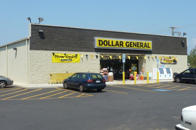
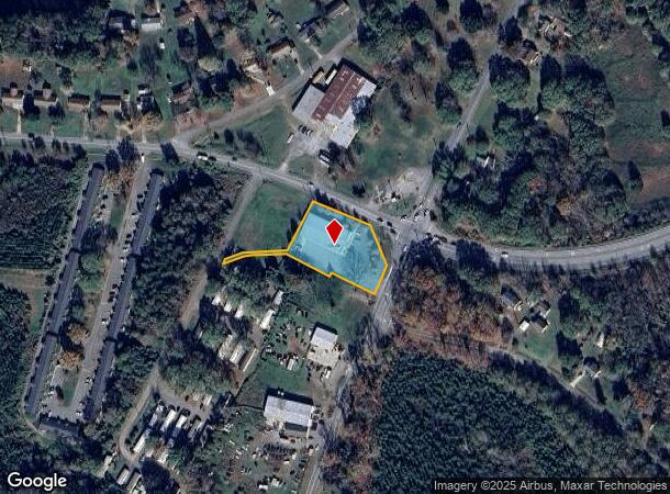
Property Record
1810 S Lafayette St, Shelby, NC 28152
NEARBY LISTINGS FOR SALE OR LEASE
Property Detail
1810 S Lafayette St
61709
#1 PB36-165 HWY 18S & HWY
Commercialnec
Cleveland
X
North Carolina
3710253500J
34
2025
1.10 AC
2025
Cleveland County
951200
Charlotte
8,968 SF
Shelby, NC
DEMOGRAPHICS near 1810 S Lafayette St
1 Mile
3 Mile
5 Mile
2024 Total Population
2,223
17,562
36,310
2029 Population
2,319
18,411
37,978
Pop Growth 2024-2029
+ 4.32%
+ 4.83%
+ 4.59%
Average Age
40
40
41
2024 Total Households
915
7,119
14,900
HH Growth 2024-2029
+ 4.26%
+ 4.80%
+ 4.60%
Median Household Inc
$44,803
$38,333
$43,652
Avg Household Size
2.30
2.30
2.30
2024 Avg HH Vehicles
2.00
2.00
2.00
Median Home Value
$125,926
$123,911
$137,445
Median Year Built
1976
1974
1975
Nearby Places
Map Layers
Map Styles
 Street
 Aerial
- Restaurants
- Banks
- Shops
- Fitness
- Groceries
SALE & LEASE HISTORY
LISTING DATE
SALE/LEASE

Nov 29, 2017
For Sale
Nearby Properties
Address
Land Use
TOTAL SIZE
Lot Size
Zoning
Address
Land Use
TOTAL SIZE
Lot Size
Zoning
5,036 SF
29.46 AC
CPD
Address
Land Use
TOTAL SIZE
Lot Size
Zoning
139,067 SF
25 AC
R20
Address
Land Use
TOTAL SIZE
Lot Size
Zoning
224,162 SF
15 AC
GBCU
Address
Land Use
TOTAL SIZE
Lot Size
Zoning
59,708 SF
10 AC
R10
Address
Land Use
TOTAL SIZE
Lot Size
Zoning
8,880 SF
8.28 AC
CPD
Address
Land Use
TOTAL SIZE
Lot Size
Zoning
27,337 SF
19.10 AC
LI
Address
Land Use
TOTAL SIZE
Lot Size
Zoning
40,956 SF
30.63 AC
LI
Address
Land Use
TOTAL SIZE
Lot Size
Zoning
24,652 SF
3.72 AC
R10
Address
Land Use
TOTAL SIZE
Lot Size
Zoning
52.33 AC
R8
Address
Land Use
TOTAL SIZE
Lot Size
Zoning
82.20 AC
R15
Address
Land Use
TOTAL SIZE
Lot Size
Zoning
78,165 SF
8.02 AC
GB
Address
Land Use
TOTAL SIZE
Lot Size
Zoning
134,978 SF
14.50 AC
GB2CU
Address
Land Use
TOTAL SIZE
Lot Size
Zoning
37,580 SF
2 AC
GB
Address
Land Use
TOTAL SIZE
Lot Size
Zoning
43,540 SF
2.96 AC
GI
Address
Land Use
TOTAL SIZE
Lot Size
Zoning
93.55 AC
R10
Address
Land Use
TOTAL SIZE
Lot Size
Zoning
63,281 SF
11.80 AC
NB
Address
Land Use
TOTAL SIZE
Lot Size
Zoning
36,758 SF
6.37 AC
R20CU
Address
Land Use
TOTAL SIZE
Lot Size
Zoning
130 SF
6.14 AC
CB
Address
Land Use
TOTAL SIZE
Lot Size
Zoning
35,829 SF
4 AC
GB
Address
Land Use
TOTAL SIZE
Lot Size
Zoning
3,200 SF
220.98 AC
LI
Address
Land Use
TOTAL SIZE
Lot Size
Zoning
1,104 SF
7.92 AC
R6
Address
Land Use
TOTAL SIZE
Lot Size
Zoning
8,000 SF
7.90 AC
R10
Address
Land Use
TOTAL SIZE
Lot Size
Zoning
49,947 SF
1 AC
GB
Address
Land Use
TOTAL SIZE
Lot Size
Zoning
1,416 SF
10.74 AC
R6
Address
Land Use
TOTAL SIZE
Lot Size
Zoning
45,310 SF
18.25 AC
GICU
Address
Land Use
TOTAL SIZE
Lot Size
Zoning
2,585 SF
5.62 AC
RO
Address
Land Use
TOTAL SIZE
Lot Size
Zoning
32,363 SF
11.95 AC
Address
Land Use
TOTAL SIZE
Lot Size
Zoning
19,878 SF
19.83 AC
R15
Address
Land Use
TOTAL SIZE
Lot Size
Zoning
946 SF
8.49 AC
R6
Address
Land Use
TOTAL SIZE
Lot Size
Zoning
21,208 SF
5.65 AC
GB
The World's #1 Commercial Real Estate Marketplace
Connect with us
© 2025 CoStar Group
The information above has been obtained from sources believed reliable. While we do not doubt its accuracy we have not verified it and make no guarantee, warranty or representation about it. It is your responsibility to independently confirm its accuracy and completeness. Any projections, opinions, assumptions, or estimates used are for example only and do not represent the current or future performance of the property. The value of this transaction to you depends on tax and other factors which should be evaluated by your tax, financial, and legal advisors. You and your advisors should conduct a careful, independent investigation of the property to determine to your satisfaction the suitability of the property for your needs.