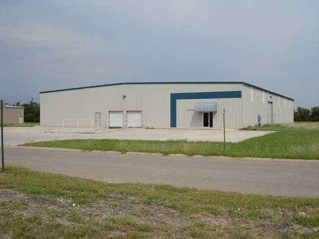
Property Record
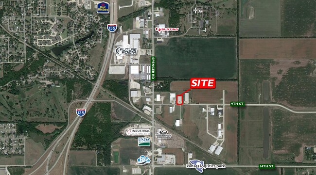
1810 Se 9Th St, Newton, KS 67114

NEARBY LISTINGS FOR SALE OR LEASE
Property Detail
1810 Se 9Th St
Wichita, KS
Newton Area Industrial Park
095-22-0-30-02-006.00-0
NEWTON AREA INDUSTRIAL PARK, S22, T23, R01E, BLOCK 1, LOT 4, ACRES 2.1
Warehouse
Harvey
X
Kansas
20079C0212E
4
2024
2.10 AC
2025
Newton/Hesston
030400
Wichita
18,000 SF
DEMOGRAPHICS near 1810 Se 9Th St
1 Mile
3 Mile
5 Mile
2024 Total Population
576
16,598
21,532
2029 Population
570
16,512
21,404
Pop Growth 2024-2029
(1.04%)
(0.52%)
(0.59%)
Average Age
43
40
41
2024 Total Households
237
6,674
8,596
HH Growth 2024-2029
(1.27%)
(0.58%)
(0.65%)
Median Household Inc
$68,709
$59,565
$61,250
Avg Household Size
2.30
2.40
2.40
2024 Avg HH Vehicles
2.00
2.00
2.00
Median Home Value
$103,788
$121,346
$131,113
Median Year Built
1967
1960
1963
Nearby Places
- Restaurants
- Banks
- Shops
- Fitness
- Groceries
PUBLIC TRANSPORTATION
COMMUTER RAIL
DRIVE
WALK
Distance
6 min
2.9 mi
AIRPORT
Wichita Dwight D Eisenhower Ntl
DRIVE
WALK
Distance
Wichita Dwight D Eisenhower Ntl
42 min
32.2 mi
SALE & LEASE HISTORY
LISTING DATE
SALE/LEASE

Mar 29, 2017
For Sale
Mar 17, 2017
For Sale
Mar 08, 2017
For Sale
Mar 03, 2017
For Sale
Jun 11, 2021
For Lease
Jun 11, 2021
For Sale
Jan 05, 2024
For Lease
Aug 04, 2017
For Sale
Apr 17, 2017
For Sale
Apr 04, 2017
For Sale
Nearby Properties
Address
Land Use
TOTAL SIZE
Lot Size
Zoning
Address
Land Use
TOTAL SIZE
Lot Size
Zoning
3,400 SF
46.30 AC
Address
Land Use
TOTAL SIZE
Lot Size
Zoning
33,598 SF
4 AC
Address
Land Use
TOTAL SIZE
Lot Size
Zoning
145,392 SF
33 AC
R3
Address
Land Use
TOTAL SIZE
Lot Size
Zoning
81,340 SF
12.31 AC
Address
Land Use
TOTAL SIZE
Lot Size
Zoning
53,443 SF
11.52 AC
Address
Land Use
TOTAL SIZE
Lot Size
Zoning
16,998 SF
306.10 AC
Address
Land Use
TOTAL SIZE
Lot Size
Zoning
61,740 SF
2.39 AC
Address
Land Use
TOTAL SIZE
Lot Size
Zoning
19,697 SF
0.15 AC
Address
Land Use
TOTAL SIZE
Lot Size
Zoning
51,225 SF
5.70 AC
R1
Address
Land Use
TOTAL SIZE
Lot Size
Zoning
49,910 SF
17.05 AC
R1
Address
Land Use
TOTAL SIZE
Lot Size
Zoning
52,180 SF
6.20 AC
R1
Address
Land Use
TOTAL SIZE
Lot Size
Zoning
49,644 SF
10.60 AC
R1
Address
Land Use
TOTAL SIZE
Lot Size
Zoning
36,685 SF
6.10 AC
Address
Land Use
TOTAL SIZE
Lot Size
Zoning
17,253 SF
2.30 AC
PO
Address
Land Use
TOTAL SIZE
Lot Size
Zoning
64,131 SF
1.60 AC
PO
Address
Land Use
TOTAL SIZE
Lot Size
Zoning
32,973 SF
1.40 AC
Address
Land Use
TOTAL SIZE
Lot Size
Zoning
8,670 SF
37.26 AC
Address
Land Use
TOTAL SIZE
Lot Size
Zoning
21,337 SF
1 AC
R1
Address
Land Use
TOTAL SIZE
Lot Size
Zoning
17,926 SF
0.14 AC
Address
Land Use
TOTAL SIZE
Lot Size
Zoning
29,115 SF
0.60 AC
Address
Land Use
TOTAL SIZE
Lot Size
Zoning
2,558 SF
2.82 AC
Address
Land Use
TOTAL SIZE
Lot Size
Zoning
13,246 SF
1.20 AC
Address
Land Use
TOTAL SIZE
Lot Size
Zoning
93,229 SF
18.28 AC
Address
Land Use
TOTAL SIZE
Lot Size
Zoning
15,116 SF
2.50 AC
Address
Land Use
TOTAL SIZE
Lot Size
Zoning
18,431 SF
1.10 AC
Address
Land Use
TOTAL SIZE
Lot Size
Zoning
19,915 SF
0.15 AC
Address
Land Use
TOTAL SIZE
Lot Size
Zoning
10,625 SF
215.65 AC
Address
Land Use
TOTAL SIZE
Lot Size
Zoning
13,838 SF
2.40 AC
R2
Address
Land Use
TOTAL SIZE
Lot Size
Zoning
17,356 SF
1.55 AC
Address
Land Use
TOTAL SIZE
Lot Size
Zoning
12,600 SF
3.70 AC
The World's #1 Commercial Real Estate Marketplace
Connect with us
© 2025 CoStar Group
The information above has been obtained from sources believed reliable. While we do not doubt its accuracy we have not verified it and make no guarantee, warranty or representation about it. It is your responsibility to independently confirm its accuracy and completeness. Any projections, opinions, assumptions, or estimates used are for example only and do not represent the current or future performance of the property. The value of this transaction to you depends on tax and other factors which should be evaluated by your tax, financial, and legal advisors. You and your advisors should conduct a careful, independent investigation of the property to determine to your satisfaction the suitability of the property for your needs.