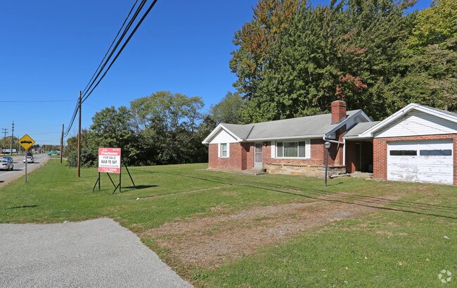
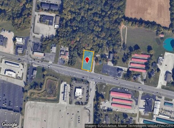
Property Record
1810 State Route 125, Amelia, OH 45102
NEARBY LISTINGS FOR SALE OR LEASE
Property Detail
1810 State Route 125
Cincinnati, OH-KY-IN
Greens Military Survey #4919
03-20-19C-145
Clermont
Residentialnec
Ohio
X
0.46 AC
39025C0240G
Eastgate/Anderson Twp
1,072 SF
Cincinnati/Dayton
DEMOGRAPHICS near 1810 State Route 125
1 Mile
3 Mile
5 Mile
2024 Total Population
3,847
24,695
51,420
2029 Population
3,988
25,534
53,127
Pop Growth 2024-2029
+ 3.67%
+ 3.40%
+ 3.32%
Average Age
37
39
40
2024 Total Households
1,506
9,374
19,867
HH Growth 2024-2029
+ 3.65%
+ 3.42%
+ 3.36%
Median Household Inc
$51,988
$65,601
$67,649
Avg Household Size
2.50
2.60
2.50
2024 Avg HH Vehicles
2.00
2.00
2.00
Median Home Value
$178,110
$201,267
$222,447
Median Year Built
1991
1992
1990
Nearby Places
Map Layers
Map Styles
 Street
 Aerial
- Restaurants
- Banks
- Shops
- Fitness
- Groceries
PUBLIC TRANSPORTATION
AIRPORT
Cincinnati/Northern Kentucky International
DRIVE
WALK
Distance
Cincinnati/Northern Kentucky International
37 min
29.5 mi
Freight Ports
Virginia Port Authority - Richmond
DRIVE
WALK
Distance
Virginia Port Authority - Richmond
1 min
383.1 mi
SALE & LEASE HISTORY
LISTING DATE
SALE/LEASE

Oct 24, 2018
For Sale
May 11, 2017
For Sale
Jun 05, 2018
For Sale
Aug 30, 2017
For Sale
Nearby Properties
Address
Land Use
TOTAL SIZE
Lot Size
Zoning
Address
Land Use
TOTAL SIZE
Lot Size
Zoning
16.02 AC
Address
Land Use
TOTAL SIZE
Lot Size
Zoning
1,380 SF
8.78 AC
Address
Land Use
TOTAL SIZE
Lot Size
Zoning
65,720 SF
7.49 AC
Address
Land Use
TOTAL SIZE
Lot Size
Zoning
216,760 SF
26.34 AC
Address
Land Use
TOTAL SIZE
Lot Size
Zoning
7,822 SF
8.47 AC
Address
Land Use
TOTAL SIZE
Lot Size
Zoning
67,894 SF
6.02 AC
Address
Land Use
TOTAL SIZE
Lot Size
Zoning
65,720 SF
7.49 AC
Address
Land Use
TOTAL SIZE
Lot Size
Zoning
19,654 SF
11.57 AC
Address
Land Use
TOTAL SIZE
Lot Size
Zoning
44.65 AC
Address
Land Use
TOTAL SIZE
Lot Size
Zoning
6,362 SF
12.60 AC
Address
Land Use
TOTAL SIZE
Lot Size
Zoning
7,200 SF
58.94 AC
Address
Land Use
TOTAL SIZE
Lot Size
Zoning
10,728 SF
13.40 AC
Address
Land Use
TOTAL SIZE
Lot Size
Zoning
2,050 SF
14.01 AC
Address
Land Use
TOTAL SIZE
Lot Size
Zoning
1,032 SF
8.41 AC
Address
Land Use
TOTAL SIZE
Lot Size
Zoning
23,674 SF
3.95 AC
Address
Land Use
TOTAL SIZE
Lot Size
Zoning
10,731 SF
6.92 AC
Address
Land Use
TOTAL SIZE
Lot Size
Zoning
24,168 SF
6.90 AC
Address
Land Use
TOTAL SIZE
Lot Size
Zoning
16.85 AC
Address
Land Use
TOTAL SIZE
Lot Size
Zoning
23.04 AC
Address
Land Use
TOTAL SIZE
Lot Size
Zoning
16,100 SF
2.80 AC
Address
Land Use
TOTAL SIZE
Lot Size
Zoning
22,536 SF
2.98 AC
Address
Land Use
TOTAL SIZE
Lot Size
Zoning
15,400 SF
5.03 AC
Address
Land Use
TOTAL SIZE
Lot Size
Zoning
3,764 SF
1 AC
Address
Land Use
TOTAL SIZE
Lot Size
Zoning
45,684 SF
6.07 AC
Address
Land Use
TOTAL SIZE
Lot Size
Zoning
10,640 SF
1.27 AC
Address
Land Use
TOTAL SIZE
Lot Size
Zoning
13,318 SF
5 AC
Address
Land Use
TOTAL SIZE
Lot Size
Zoning
2,540 SF
33.14 AC
Address
Land Use
TOTAL SIZE
Lot Size
Zoning
14,476 SF
2.60 AC
Address
Land Use
TOTAL SIZE
Lot Size
Zoning
14,386 SF
1.65 AC
Address
Land Use
TOTAL SIZE
Lot Size
Zoning
1,600 SF
5.87 AC
The World's #1 Commercial Real Estate Marketplace
Connect with us
© 2025 CoStar Group
The information above has been obtained from sources believed reliable. While we do not doubt its accuracy we have not verified it and make no guarantee, warranty or representation about it. It is your responsibility to independently confirm its accuracy and completeness. Any projections, opinions, assumptions, or estimates used are for example only and do not represent the current or future performance of the property. The value of this transaction to you depends on tax and other factors which should be evaluated by your tax, financial, and legal advisors. You and your advisors should conduct a careful, independent investigation of the property to determine to your satisfaction the suitability of the property for your needs.