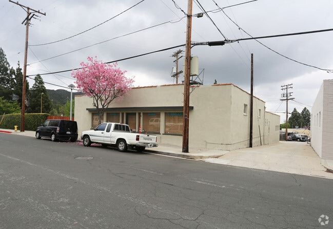
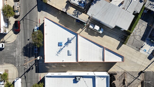
Property Record
1810 Sunview Dr, Glendale, CA 91208


Current Lease Availabilities
Property Detail
1810 Sunview Dr
5615-009-018
SPARR HEIGHTS LOT 29 BLK 28
Storemultistory
LOS ANGELES
GLC3*
California
B and X Area of moderate flood hazard, usually the area between the limits of the 100-year and 500-year floods.
29
2024
0.06 AC
2025
Glendale
300701
Los Angeles
2,796 SF
Los Angeles-Long Beach-Glendale, CA
NEARBY LISTINGS FOR SALE OR LEASE
DEMOGRAPHICS near 1810 Sunview Dr
1 mile
3 mile
5 mile
2025 Total Population
15,444
80,261
306,627
2030 Population
15,211
79,188
302,345
Pop Growth 2025-2030
(1.51%)
(1.34%)
(1.40%)
Average Age
43
44
43
2025 Total Households
5,929
28,327
114,847
HH Growth 2025-2030
(1.79%)
(1.63%)
(1.64%)
Median Household Inc
$109,460
$144,892
$96,594
Avg Household Size
2.60
2.80
2.60
2025 Avg HH Vehicles
2.00
2.00
2.00
Median Home Value
$1,081,837
$1,107,927
$1,056,097
Median Year Built
1960
1957
1961
Nearby Places
Map Layers
Map Styles
 Street
 Aerial
Layers
 Traffic
 Biking
Places
Listings with unknown addresses are not visible on the map
- Restaurants
- Banks
- Shops
- Fitness
- Groceries
PUBLIC TRANSPORTATION
COMMUTER RAIL
Downtown Burbank (Antelope Valley Line - Southern California Regional Rail Authority (Metrolink), Ventura County Line - Southern California Regional Rail Authority (Metrolink))
Drive
Walk
Distance
Downtown Burbank (Antelope Valley Line - Southern California Regional Rail Authority (Metrolink), Ventura County Line - Southern California Regional Rail Authority (Metrolink))
16 min
8.7 mi
Glendale (Antelope Valley Line - Southern California Regional Rail Authority (Metrolink), Ventura County Line - Southern California Regional Rail Authority (Metrolink))
Drive
Walk
Distance
Glendale (Antelope Valley Line - Southern California Regional Rail Authority (Metrolink), Ventura County Line - Southern California Regional Rail Authority (Metrolink))
13 min
8.8 mi
AIRPORT
Bob Hope
Drive
Walk
Distance
Bob Hope
20 min
12.1 mi
Los Angeles International
Drive
Walk
Distance
Los Angeles International
41 min
26.9 mi
Long Beach (Daugherty Field)
Drive
Walk
Distance
Long Beach (Daugherty Field)
46 min
33.3 mi
Freight Ports
Port of Long Beach
Drive
Walk
Distance
Port of Long Beach
48 min
36.2 mi
Nearby Properties
Address
Land Use
TOTAL SIZE
Lot Size
Zoning
Address
Land Use
TOTAL SIZE
Lot Size
Zoning
386,909 SF
9.29 AC
GLC3*
Address
Land Use
TOTAL SIZE
Lot Size
Zoning
86,008 SF
3.75 AC
GLR3YY
Address
Land Use
TOTAL SIZE
Lot Size
Zoning
86,163 SF
4.20 AC
GLR3*
Address
Land Use
TOTAL SIZE
Lot Size
Zoning
175,037 SF
4.77 AC
LFC2*
Address
Land Use
TOTAL SIZE
Lot Size
Zoning
80,150 SF
1.47 AC
LCC1-R2*
Address
Land Use
TOTAL SIZE
Lot Size
Zoning
86,141 SF
8.79 AC
LFR1
Address
Land Use
TOTAL SIZE
Lot Size
Zoning
85,146 SF
2.29 AC
GLC3*
Address
Land Use
TOTAL SIZE
Lot Size
Zoning
52,278 SF
1.96 AC
GLR4*
Address
Land Use
TOTAL SIZE
Lot Size
Zoning
48,664 SF
3.42 AC
GLC3*
Address
Land Use
TOTAL SIZE
Lot Size
Zoning
46,812 SF
2.77 AC
GLC3*
Address
Land Use
TOTAL SIZE
Lot Size
Zoning
41,987 SF
2.09 AC
LFCPD*
Address
Land Use
TOTAL SIZE
Lot Size
Zoning
45,927 SF
2.16 AC
Address
Land Use
TOTAL SIZE
Lot Size
Zoning
28,636 SF
1.09 AC
GLR3*
Address
Land Use
TOTAL SIZE
Lot Size
Zoning
41,448 SF
2.96 AC
GLR4-R1*
Address
Land Use
TOTAL SIZE
Lot Size
Zoning
64,235 SF
1.44 AC
GLC2*
Address
Land Use
TOTAL SIZE
Lot Size
Zoning
55,366 SF
102.25 AC
GLSR*
Address
Land Use
TOTAL SIZE
Lot Size
Zoning
61,346 SF
1.32 AC
GLC3*
Address
Land Use
TOTAL SIZE
Lot Size
Zoning
32,754 SF
3.82 AC
LFR3-R1200
Address
Land Use
TOTAL SIZE
Lot Size
Zoning
59,744 SF
0.93 AC
GLC3-R1*
Address
Land Use
TOTAL SIZE
Lot Size
Zoning
28,904 SF
0.89 AC
GLR3*
Address
Land Use
TOTAL SIZE
Lot Size
Zoning
35,745 SF
1.11 AC
GLR3R*
Address
Land Use
TOTAL SIZE
Lot Size
Zoning
125,000 SF
3.32 AC
LFR110000-
Address
Land Use
TOTAL SIZE
Lot Size
Zoning
66,163 SF
0.62 AC
GLC3*
Address
Land Use
TOTAL SIZE
Lot Size
Zoning
29,794 SF
0.37 AC
GLM1A*
Address
Land Use
TOTAL SIZE
Lot Size
Zoning
92,489 SF
2.03 AC
GLC3*
Address
Land Use
TOTAL SIZE
Lot Size
Zoning
74,944 SF
2.10 AC
Address
Land Use
TOTAL SIZE
Lot Size
Zoning
88,624 SF
5 AC
LCR330U*
Address
Land Use
TOTAL SIZE
Lot Size
Zoning
Address
Land Use
TOTAL SIZE
Lot Size
Zoning
52,252 SF
5.22 AC
LFR17500*
Address
Land Use
TOTAL SIZE
Lot Size
Zoning
17,754 SF
1.70 AC
The World's #1 Commercial Real Estate Marketplace
Connect with us
© 2026 CoStar Group
The information above has been obtained from sources believed reliable. While we do not doubt its accuracy we have not verified it and make no guarantee, warranty or representation about it. It is your responsibility to independently confirm its accuracy and completeness. Any projections, opinions, assumptions, or estimates used are for example only and do not represent the current or future performance of the property. The value of this transaction to you depends on tax and other factors which should be evaluated by your tax, financial, and legal advisors. You and your advisors should conduct a careful, independent investigation of the property to determine to your satisfaction the suitability of the property for your needs.