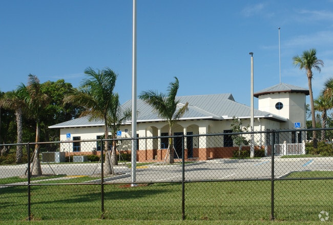
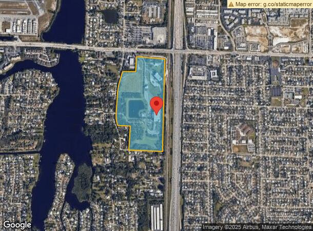
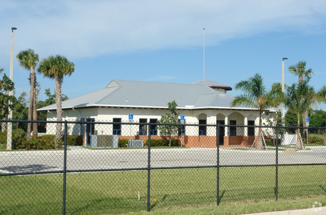
Property Record
1810 W Lantana Rd, Lantana, FL 33462
NEARBY LISTINGS FOR SALE OR LEASE
Property Detail
1810 W Lantana Rd
South Florida
Acreage & Unrec
West Palm Beach-Boca Raton-Delray Beach, FL
4-45-43~ PT OF GOV LT 4 LYG BET HIGH RIDGE RD~ CSX RY & S OF & ADJ TO I-95 ACCESS R/WS (LESS PB106P31) & PT OF NW 1/4 LYG BET HIGH RIDGE RD~ CSX RY & N
40-43-45-04-00-004-0030
Palm Beach
Municipalproperty
Florida
0
4
2025
63.40 AC
005807
Boynton/Lantana
122,613 SF
DEMOGRAPHICS near 1810 W Lantana Rd
1 Mile
3 Mile
5 Mile
2024 Total Population
11,886
126,518
296,943
2029 Population
12,316
131,648
308,534
Pop Growth 2024-2029
+ 3.62%
+ 4.05%
+ 3.90%
Average Age
39
40
41
2024 Total Households
4,321
48,235
113,690
HH Growth 2024-2029
+ 2.89%
+ 4.28%
+ 4.09%
Median Household Inc
$58,852
$60,835
$62,078
Avg Household Size
2.50
2.40
2.50
2024 Avg HH Vehicles
2.00
2.00
2.00
Median Home Value
$283,920
$284,327
$285,354
Median Year Built
1979
1982
1982
Nearby Places
Map Layers
Map Styles
 Street
 Aerial
- Restaurants
- Banks
- Shops
- Fitness
- Groceries
PUBLIC TRANSPORTATION
COMMUTER RAIL
Boynton Beach (Tri-County Commuter - South Florida Regional Transportation Authority (Tri-Rail))
DRIVE
WALK
Distance
Boynton Beach (Tri-County Commuter - South Florida Regional Transportation Authority (Tri-Rail))
6 min
2.9 mi
Lake Worth (Tri-County Commuter - South Florida Regional Transportation Authority (Tri-Rail))
DRIVE
WALK
Distance
Lake Worth (Tri-County Commuter - South Florida Regional Transportation Authority (Tri-Rail))
9 min
3.1 mi
AIRPORT
Palm Beach International
DRIVE
WALK
Distance
Palm Beach International
17 min
9.8 mi
Freight Ports
Port of Palm Beach
DRIVE
WALK
Distance
Port of Palm Beach
27 min
15.1 mi
Nearby Properties
Address
Land Use
TOTAL SIZE
Lot Size
Zoning
Address
Land Use
TOTAL SIZE
Lot Size
Zoning
337,437 SF
8.01 AC
C3
Address
Land Use
TOTAL SIZE
Lot Size
Zoning
1,346,412 SF
23.09 AC
HD PUD
Address
Land Use
TOTAL SIZE
Lot Size
Zoning
902,798 SF
112.99 AC
PO
Address
Land Use
TOTAL SIZE
Lot Size
Zoning
1,028,686 SF
63.78 AC
PID
Address
Land Use
TOTAL SIZE
Lot Size
Zoning
81,194 SF
675.47 AC
PO
Address
Land Use
TOTAL SIZE
Lot Size
Zoning
508,032 SF
18 AC
MXD
Address
Land Use
TOTAL SIZE
Lot Size
Zoning
436,808 SF
15.03 AC
MUPD
Address
Land Use
TOTAL SIZE
Lot Size
Zoning
357,168 SF
16.13 AC
MXD
Address
Land Use
TOTAL SIZE
Lot Size
Zoning
441,081 SF
20.08 AC
PUD
Address
Land Use
TOTAL SIZE
Lot Size
Zoning
327,864 SF
9.21 AC
MW
Address
Land Use
TOTAL SIZE
Lot Size
Zoning
311,983 SF
7.15 AC
C1
Address
Land Use
TOTAL SIZE
Lot Size
Zoning
340,811 SF
49.49 AC
PID
Address
Land Use
TOTAL SIZE
Lot Size
Zoning
443,576 SF
92.86 AC
PO
Address
Land Use
TOTAL SIZE
Lot Size
Zoning
211,774 SF
304.50 AC
PO
Address
Land Use
TOTAL SIZE
Lot Size
Zoning
353,007 SF
33.60 AC
RS
Address
Land Use
TOTAL SIZE
Lot Size
Zoning
437,380 SF
18.05 AC
PID
Address
Land Use
TOTAL SIZE
Lot Size
Zoning
303,078 SF
19.62 AC
PUD
Address
Land Use
TOTAL SIZE
Lot Size
Zoning
381,807 SF
3.98 AC
SMU
Address
Land Use
TOTAL SIZE
Lot Size
Zoning
296,278 SF
13.05 AC
PUD
Address
Land Use
TOTAL SIZE
Lot Size
Zoning
334,014 SF
3.35 AC
SMU
Address
Land Use
TOTAL SIZE
Lot Size
Zoning
214,095 SF
7.67 AC
PUD
Address
Land Use
TOTAL SIZE
Lot Size
Zoning
240,786 SF
10.63 AC
R3
Address
Land Use
TOTAL SIZE
Lot Size
Zoning
476,774 SF
38.76 AC
RM
Address
Land Use
TOTAL SIZE
Lot Size
Zoning
296,033 SF
2.04 AC
TOD-E
Address
Land Use
TOTAL SIZE
Lot Size
Zoning
291,589 SF
11.63 AC
PID
Address
Land Use
TOTAL SIZE
Lot Size
Zoning
178,602 SF
7.61 AC
MU-W
Address
Land Use
TOTAL SIZE
Lot Size
Zoning
251,292 SF
18.59 AC
I-POC
Address
Land Use
TOTAL SIZE
Lot Size
Zoning
215,310 SF
21.35 AC
PUD
Address
Land Use
TOTAL SIZE
Lot Size
Zoning
344,466 SF
24.37 AC
P
Address
Land Use
TOTAL SIZE
Lot Size
Zoning
263,799 SF
8.36 AC
PUD
The World's #1 Commercial Real Estate Marketplace
Connect with us
© 2026 CoStar Group
The information above has been obtained from sources believed reliable. While we do not doubt its accuracy we have not verified it and make no guarantee, warranty or representation about it. It is your responsibility to independently confirm its accuracy and completeness. Any projections, opinions, assumptions, or estimates used are for example only and do not represent the current or future performance of the property. The value of this transaction to you depends on tax and other factors which should be evaluated by your tax, financial, and legal advisors. You and your advisors should conduct a careful, independent investigation of the property to determine to your satisfaction the suitability of the property for your needs.